Discover how is land value calculated using comparative sales, residual methods, and ground rents, plus the critical differences between leases and use rights.
October 1, 2026
How Is Land Value Calculated for Public Policy
Discover how is land value calculated using comparative sales, residual methods, and ground rents, plus the critical differences between leases and use rights.

The most popular advice about land valuation is also the least reliable for public policy: take the property price and subtract the building cost. That shortcut can produce a workable private appraisal, but it doesn't answer the municipal question, how is land value calculated when the objective is to measure the value of a location apart from private improvements?
A public valuation system needs to identify the value created by nature, location, planning, infrastructure, and community growth, then distinguish it from the value created by labor and capital. The result is an administrative estimate, not a perfectly observed price. That distinction matters for taxation, land-value capture, housing policy, and decisions about whether a charge falls on passive landholding or productive activity.
Table of Contents
- Rethinking Unimproved Site Valuation
- Core Methods for Estimating Land Value
- Income Capitalization and Ground Rent Approaches
- Land Leases Versus True Land-Use Rights
- Separating Public Value from Private Improvements
- Implementation Notes for Public Valuation Systems
Rethinking Unimproved Site Valuation
The sale price of a completed property is not a land value. It is the combined result of the site, buildings, infrastructure, planning conditions, labor, finance, and management. Tri-factor economics provides a disciplined way to separate the site contribution from improvements and services, rather than assigning the entire transaction price to the landowner.
That distinction matters for public valuation. The relevant question is what the parcel would command without private improvements, while retaining its legally permitted and economically realistic use. Access to employment, public infrastructure, planning decisions, population growth, and nearby investment can raise the value of a location. Those advantages may accrue to the owner even when public institutions, surrounding residents, or earlier investment created them.
A municipality therefore needs a repeatable estimate of unimproved site value. A residual calculation can support that estimate, but it is not automatically reliable. It depends on assumptions about construction costs, depreciation, finance, developer profit, timing, and the site's future use. Weak assumptions turn the residual into a container for valuation error.
The leftover model has a narrow use
The familiar formula is:
Land value = total property value − value of improvements
The formula is simple. Its inputs are not. A building's market value may differ from its construction cost because age, condition, design, obsolescence, and permitted use influence buyer behavior. The existing structure may also understate the site's economically realistic potential. A low-rise building on a transit-accessible parcel, for example, may occupy land suited to a more valuable use. Deducting the building's apparent value without testing that potential can produce a misleading site estimate.
The Wales feasibility study on land valuation methods describes a more explicit sequence. Analysts estimate a representative property price, derive land-to-building ratios from land and property transactions, then combine the predicted property price with those ratios to estimate land value. This can help where vacant-land transactions are limited, although the result remains sensitive to the quality of the ratios, the transaction evidence, and the assumptions used to standardize properties.
Tax treatment creates a separate analytical issue. The ATO capital gains tax vacant land guidance provides context for Australian property questions, but tax liability should not be treated as a measure of unimproved site value. The two subjects may inform public policy in different ways, yet they answer different questions.
What public bodies are actually measuring
Public assessors are building a consistent estimate across many parcels, including sites that have not sold recently. The system needs a clear definition of the subject interest, consistent treatment of planning and access conditions, transparent assumptions, and a method for recording uncertainty. Scale makes consistency as important as theoretical precision.
The land value overview from Unitism helps distinguish the site from private improvements and explains why land-based policy focuses on location value. Applied in a public system, that distinction requires assessors to identify which advantages arise from the parcel, which arise from structures, and which reflect public or community-created conditions.
A true land-use right must also be kept separate from an ordinary fixed-term lease. A lease grants contractual possession for a defined period and may include rent, renewal terms, restrictions, or obligations that affect its market value. It does not automatically represent permanent or equivalent rights to the underlying land. Public calculations should specify whether they value the fee-simple site, a defined land-use right, or a leasehold interest, then adjust for duration and conditions rather than treating every occupancy arrangement as land ownership.
Practical rule: Treat unimproved land value as a modeled public measurement with an evidence trail, not as an obvious number hidden inside a sale price.
The fiscal purpose follows from that definition. A government seeking to shift taxation away from work, construction, or productive investment first needs a defensible estimate of location value that those activities did not create. The valuation method sets the foundation for the policy instrument.
Core Methods for Estimating Land Value
A vacant-lot sale is not automatically the best evidence of unimproved site value. Public assessors often face too few transactions, inconsistent planning permissions, and parcels affected by access, environmental, or infrastructure constraints. The workable answer is a calibrated combination of methods, applied consistently across comparable sites and adjusted to the interest being valued.
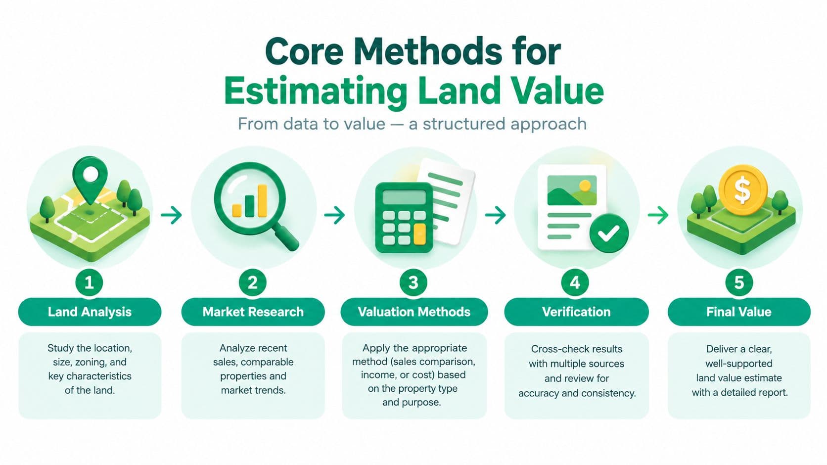
A workable comparison and allocation sequence
A public valuation team can organise the analysis in five stages:
-
Define the subject interest and permitted use. Record the parcel, ownership interest, planning status, access, easements, environmental restrictions, and realistic highest-value use. A true land-use right must be identified separately from a standard fixed-term lease, whose duration and contractual conditions can materially affect value.
-
Estimate a representative improved property price. Use comparable transactions, hedonic analysis, or another market model to estimate what a typical completed property would command in the relevant area.
-
Separate land from improvements. Apply allocation, extraction, or residual analysis using available land and property evidence. The purpose is to establish a defensible relationship between the site and the structures, rather than treating the whole sale price as land value.
-
Apply the relationship to the subject parcel. Combine the predicted property price with the selected land-to-building ratio or extracted land component, while adjusting for the parcel's permissions and physical constraints.
-
Test the result against other evidence. Compare the modelled estimate with vacant-site transactions, ground rents, development feasibility, and local planning conditions where those sources exist.
The mass appraisal methods guide from Unitism offers relevant context for applying this logic across large property datasets. A method that appears reasonable for one parcel still requires calibration, validation, and periodic review before a government applies it across a district.
Where the evidence becomes thin
Land-only transactions may be too scarce to support direct observation across every location. Many public estimates therefore rely on inferred relationships between improved property prices, building costs, planning permissions, and site characteristics. Sparse evidence can make a model look precise while leaving substantial uncertainty around the result.
Historical ratios create further risk. A relationship derived from past transactions may miss an announced transit project, a rezoning decision, or a new environmental designation. Static models can also fail to capture speculative price movements, political effects embedded in official rates, or infrastructure that changes a site's future earning capacity.
Development feasibility analysis provides a useful check when the site's potential drives value. It tests construction costs, funding, holding periods, project risk, and the amount a developer could reasonably pay. Municipal teams interpreting a proposed acquisition price should understand commercial developer finance, because financing conditions affect private bidding capacity without automatically defining the public estimate of unimproved site value.
The strongest practice is triangulation. Use comparable sales where they exist, allocation or extraction where improved transactions dominate, and development or income analysis where permitted use drives the price. Publish the assumptions, adjustments, and uncertainty that matter most. A modelled output is a policy measurement with an evidence trail, not an observed fact hidden inside a transaction price.
Income Capitalization and Ground Rent Approaches
Income methods are most useful when land sales are limited or a site's value depends on the income its permitted use can generate. The calculation starts by isolating income attributable to the land, then converting that income into a capital value. The difficult judgment is attribution. Buildings, financing, management, operating businesses, and risk may each account for part of the observed income.
For an income-producing property, an assessor may start with net operating income. For a development site, the starting point may be gross development value, meaning the expected value of the completed project. The analyst then deducts building and improvement costs, construction and professional fees, finance and holding costs, and a normal developer profit. The balance is the land-attributable value. A residual land value explanation from Unitism provides a useful review of how completed-project value, development costs, and required returns interact.
Ground rent capitalization
Ground rent capitalization isolates the income associated with the site more directly. Where a site produces sustainable ground rent, the assessor can capitalize that rent using a land capitalization rate. The rate should reflect available market evidence and the risk of the income stream. Analysts may derive it from a market study, a band-of-investment approach, or a summation method.
The basic calculation is:
Capitalized land value = land-attributable income ÷ land capitalization rate
The formula is simple. The rate selection is not. A lower rate produces a higher capital value, while a higher rate produces a lower value. Land often receives the residual return after other costs and required returns are paid, so a modest rate change can materially alter the estimate.
Ground rent evidence also requires policy judgment. Existing rent may reflect a negotiated contract, an administrative rule, or a temporary market imbalance rather than the current value of the underlying site. For public valuation systems, the assessor should identify whether the observed rent represents unrestricted land-use value or a particular contractual arrangement.
Residual methods need skepticism
Residual valuation is highly sensitive to assumptions. Inflated sale expectations, understated construction costs, insufficient depreciation, or an unrealistic developer profit can produce a land value that an informed buyer would not pay. The California Board of Equalization lesson on land valuation notes that residual approaches can generate unstable or sensitive results when the supporting evidence is weak.
A municipal review should test five points:
- Income quality: Is the operating income observable, sustainable, and attributable to the site rather than the building or an operating business?
- Cost completeness: Does the model include improvement costs, finance charges, depreciation, and normal developer profit?
- Rate evidence: Can the capitalization rate be supported by market observations or a documented derivation?
- Scenario resilience: Does the estimate remain plausible when key assumptions change?
- Use consistency: Does the proposed use comply with planning rules and site constraints while representing the most valuable realistic use?
Modeling discipline: A residual value is not a fact discovered at the bottom of a spreadsheet. It is the result of linked assumptions, and each link needs an evidence rating.
Ground rent methods suit stable, income-producing sites, but they do not automatically outperform sales comparison. They may reproduce outdated lease terms or policy distortions. Residual methods can capture development potential, while also magnifying errors in forecasts. The appropriate method depends on the evidence. A prudent assessor reports sensitivity, documents the assumptions, and distinguishes a modelled public estimate from a contractual rent or an observed transaction price.
Land Leases Versus True Land-Use Rights
Public valuation systems must identify the legal interest being assessed before they calculate a charge. Land-value tax applies to unimproved land, excluding buildings and other improvements such as drainage, crops, and site works, as explained in the Federal Highway Administration's land-value tax overview. A lease is a contractual interest for a defined term. A true land-use right, as used here, is indefinite and repriced annually.
The distinction affects both valuation and risk allocation. A fixed-term lease sets a price for an agreed period, whether it can be renewed or not. A renewable lease gives the holder security during its term, then brings the accumulated difference between the fixed rent and current market value into the renewal negotiation. A non-renewable lease loses transferability and refinancing capacity as its expiry date approaches because fewer years remain to recover the value of buildings and operations.
Legal labels do not settle the issue. An arrangement described as a “land-use right” still functions as a lease if it expires or keeps its price fixed. The assessor should classify the rights and obligations in the contract, not rely on terminology used in legislation or marketing.
The defining test
A true land-use right has three features:
- Annual repricing: The charge or price resets each year to reflect current land value.
- No renewal requirement: The holder does not need to negotiate a new term to retain the right.
- No expiry: The right is indefinite and does not run down toward a terminal date.
Annual repricing keeps the land component current while allowing the holder to build, operate, invest, or change productive activities without facing a hidden lease cliff. Buyers and lenders also avoid pricing a shrinking remaining term or an uncertain renewal event into every transfer.
| Feature | Fixed-Term Land Lease | True Land-Use Right |
|---|---|---|
| Duration | Renewable or non-renewable fixed term | Indefinite |
| Price | Fixed during the agreed term | Repriced annually |
| Renewal | Required for a renewable lease | Not required |
| Expiry risk | Present, and often increases as expiry approaches | No expiry risk |
| Trading | Can become costly or difficult as term shortens | Low-cost trading is possible because the right does not run down |
| Risk treatment | Postpones repricing and concentrates risk at renewal or expiry | Prices land risk continuously |
| Effect on enterprise | Can burden investment with refinancing and repricing risk | Does not burden productive enterprise with a fixed-term cliff |
The analysis of 99-year land leases shows why a long duration does not create an indefinite land-use right. A fixed lease still expires, and a fixed price still delays repricing. Duration is not the governing test. Indefinite tenure and annual repricing are the test.
New Zealand's tax guidance illustrates the administrative consequence. It assesses land tax against land value at noon on 31 March each year, using the current district valuation roll from the preceding year, and distinguishes leasehold interests from freehold ownership (New Zealand land tax guidance). A public valuation office therefore needs separate fields for the site value, the legal interest, the term, the rent-setting mechanism, and any expiry or renewal conditions. Without that separation, a system can apply a sound land-value method to the wrong interest and produce an unfair charge.
Separating Public Value from Private Improvements
A property's sale price combines several different sources of value. The building reflects private capital and construction decisions. The site also benefits from roads, transit, planning permission, schools, public services, and local economic activity. If a public charge applies to the combined amount, it may penalize construction and productive investment for value created partly by the community.
Land-value capture requires a more careful allocation. Analysts distinguish gains associated with private investment, public investment, and wider population or economic growth. The categories will not explain every price movement perfectly. The practical standard is to identify each driver as clearly as the available evidence allows, then disclose the assumptions behind the allocation.
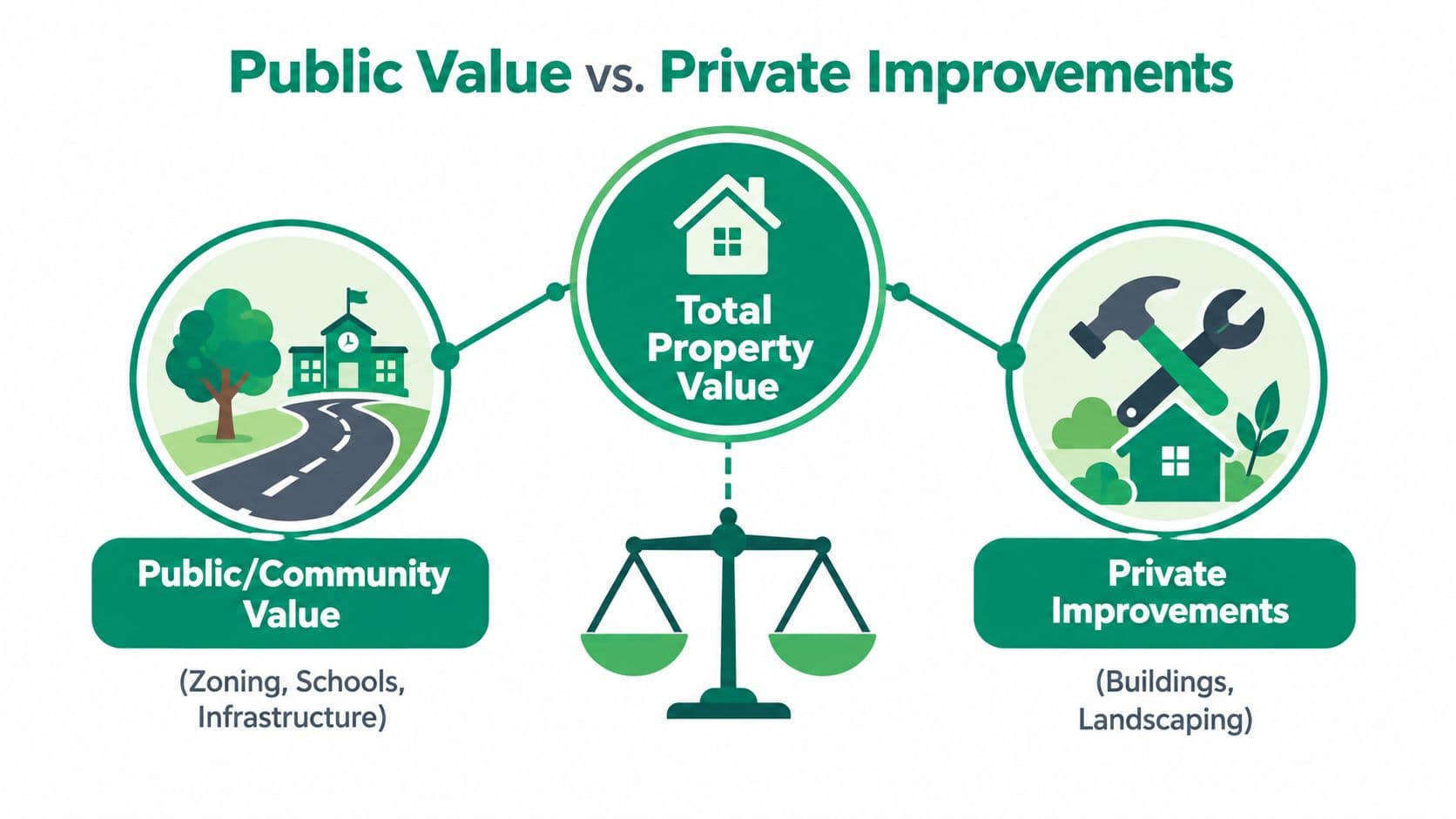
Modeling the location rather than the building
Administrative land-value models can estimate site value from location, planning, infrastructure, and amenity variables. A public body might include access to jobs and transit, planning status, nearby development, views, environmental designations, and infrastructure provision. The model should measure what the location contributes, rather than crediting the owner for constructing a better building.
That distinction matters when public decisions change development potential. Rezoning can raise a parcel's value before any construction begins. A new transit connection can improve access throughout an area. Heritage protection or an environmental restriction can narrow the viable uses and reduce site value. These effects belong in the assessment because they alter the bundle of rights and opportunities attached to the land.
The land-value uplift discussion from Unitism offers a policy framework for examining these changes without treating public and private contributions as one unexplained increase. A municipality can then decide whether the uplift should help fund infrastructure, support general services, or finance a transition in the tax base.
Why the separation affects fiscal design
A building tax charges owners for improving a site, which can discourage renovation, redevelopment, or more intensive use. A site-value charge focuses on location value that exists independently of the owner's construction choices. The result still depends on the rate, exemptions, administration, and transition rules. The valuation principle remains clear: don't confuse the value of the site with the value of what someone builds on it.
For public finance teams, the separation also improves auditability. A model should record the legal interest being assessed, the permitted use, the relevant valuation date, and the factors that changed the site estimate. That is particularly important where a public project or planning decision creates an uplift before the owner has made a private improvement.
Data science supports consistency, but it does not remove professional judgment. Analysts must test estimates against transactions, review outliers, update inputs as planning and infrastructure change, and show where evidence is thin. Public bodies should publish the principal variables, validation approach, uncertainty ranges, and appeal process so taxpayers can understand how the estimate was produced.
Policy test: If a valuation rises because a public project or planning decision improved a location, the model should show that driver rather than attributing the entire increase to private ownership.
Implementation Notes for Public Valuation Systems
A public land-value system succeeds or fails in administration. The formula is only one component. Officials need a cadastre that identifies parcels and legal interests, dependable planning and transaction records, a defined valuation date, trained assessors, an appeals process, and rules for updating values without arbitrary shocks. Mixed-use parcels, sparse vacant-site evidence, heritage controls, easements, and changing planning permissions make public assessment harder than a textbook example.
Iowa guidance identifies six acceptable methods for land assessment: sales comparison, allocation, abstraction, capitalization of ground rent, land residual capitalization, and land build-up (Iowa land valuation guidance). A public body may also use a modeled mass-appraisal system that combines location, planning, infrastructure, and amenity variables. The right choice depends on the available evidence, the legal interest being assessed, and the level of consistency required across the valuation roll. Each method should have a written rationale and an audit trail.
Build the administrative foundation first
Start by defining the assessable interest. Freehold land, leasehold interests, common rights, public land, easements, and development restrictions can require different treatment. The database should record the valuation date, legal interest, permitted use, physical characteristics, planning status, and improvements as separate fields. That structure prevents a model from treating a fixed-term lease as equivalent to an underlying land-use right.
Method selection should follow the evidence:
- Use sales comparison when comparable sites exist and differences in use, size, access, and planning status can be adjusted credibly.
- Use allocation or abstraction when improved-property transactions are plentiful but land-only sales are limited.
- Use ground rent capitalization when site income is stable and the rent reflects current market conditions.
- Use land residual capitalization when development potential drives value, while testing costs, finance, profit, timing, and expected outcomes.
- Use land build-up when market evidence supports separate components for location, access, services, and other site attributes.
- Use a modeled mass-appraisal approach when parcel volume requires consistent estimates from administrative, spatial, and market datasets.
No method is automatically correct. Zoning, heritage controls, easements, environmental designations, physical access, and infrastructure can restrict the use that appears most valuable. A nearby site with different permissions is not a valid comparable merely because its location is close. Analysts should test outputs against transactions, investigate outliers, and record where evidence is thin.
Set timing, review, and transition rules
The assessment date must be stated in legislation, guidance, and the valuation record. A jurisdiction may use an annual date, a fixed assessment cycle, or another prescribed rule. Whatever the choice, taxpayers need to know which planning, market, and property data qualified for that assessment. The system should also distinguish the ownership or use interests included in the charge, particularly where leasehold arrangements do not convey the same rights as freehold ownership.
A practical rollout can begin with a pilot district. Publish sample assessments, invite technical review, compare modeled values with observed transactions and independent appraisals, then correct systematic errors before wider adoption. Explain why each parcel's estimate changed, separate land effects from improvement effects, and provide a workable appeal route. Phasing can reduce disruption, provided it does not obscure the eventual basis of the charge.
Implementation standard: Publish the method, valuation date, principal variables, treatment of legal interests, review process, and appeal route before asking the public to rely on the result.
Unitism® provides land valuation assessments, data frameworks, policy design, fiscal impact modeling, cadastre integration, implementation support, and stakeholder education for governments and organizations working on land-based reform. These services address the administrative task of converting imperfect signals about location value into a transparent policy and valuation system.
If your finance or planning team is evaluating site-value taxation, land-value capture, or true land-use rights, visit Unitism® for valuation, policy design, and implementation resources. Use the material to frame a pilot, identify data gaps, and build a defensible transition path that distinguishes public land value from private improvements.