Learn what land zonal value means, how to calculate and map zonal land values, and how governments use them for taxation, land value capture and planning.
October 23, 2026
Land Zonal Value Explained: Methods, Maps and Policy Uses
Learn what land zonal value means, how to calculate and map zonal land values, and how governments use them for taxation, land value capture and planning.

The usual advice is to find your zone on a map and treat the published land value as the answer. That's a useful starting point, but a poor stopping point. A land zonal value is an estimate, not a guaranteed sale price or a self-explanatory tax assessment. Before a treasurer builds a budget around it, someone needs to explain what was measured, which assumptions were used, and where the estimate could be wrong.
Table of Contents
- Why Zonal Land Values Matter for Public Budgets
- Separating Land Value from Buildings and Improvements
- Calculating and Mapping Zonal Land Values
- Keeping Zonal Estimates Transparent and Defensible
- Policy Uses and Fiscal Risks in Practice
- Comparing Land Leases, Land-Use Rights and Land-Value Charges
- Taking the Next Step Toward Zonal Valuation Reform
Why Zonal Land Values Matter for Public Budgets
A colored map can make uncertain evidence look settled. Parcels inside the same boundary receive the same benchmark, so readers may assume the underlying sites are economically interchangeable. For budget planning, the safer approach is to treat the benchmark as a starting estimate that may require parcel-level adjustments.
The administrative attraction is clear. A finance department needs a consistent way to organize valuation evidence across its territory. A zonal framework can give assessors, planners, and treasury staff a shared reference point instead of leaving each department with unrelated property records.
Land's immobility makes that work especially important. An owner can move money or business activity, but cannot move the underlying site into another jurisdiction to avoid a land-based charge. That characteristic helps explain the relevance of land valuation to municipal and national finance.
A valuation map isn't a revenue forecast
A treasurer should distinguish the assessed base from the revenue the government can realistically collect. Legal exemptions, collection arrangements, transition rules, and the chosen charge all need separate attention. A published value alone doesn't answer those administrative questions.
For preliminary scenario work, RealtyAPI.io's tax estimates for real estate analysis can provide a place to explore tax calculations. Treat any calculator output as an analytical input, not confirmation that a particular zonal assessment is correct.
Budget rule: Ask separately whether the valuation is credible, whether the charge is lawful, and whether the collection forecast is realistic.
A review of municipal revenue sources can help place land-related receipts alongside the rest of the budget. The practical questions are broader than finding an attractive tax base:
- Evidence: What transactions and parcel characteristics support the benchmark?
- Administration: Who updates the assessment and handles disputes?
- Exposure: What happens to receipts when estimated values change?
- Tenure: Is the government taxing ownership, granting a lease, or administering continuing use rights?
A useful reform proposal should answer those questions before presenting a revenue total. Otherwise, officials risk confusing a tidy valuation exercise with a complete public-finance system.
Separating Land Value from Buildings and Improvements
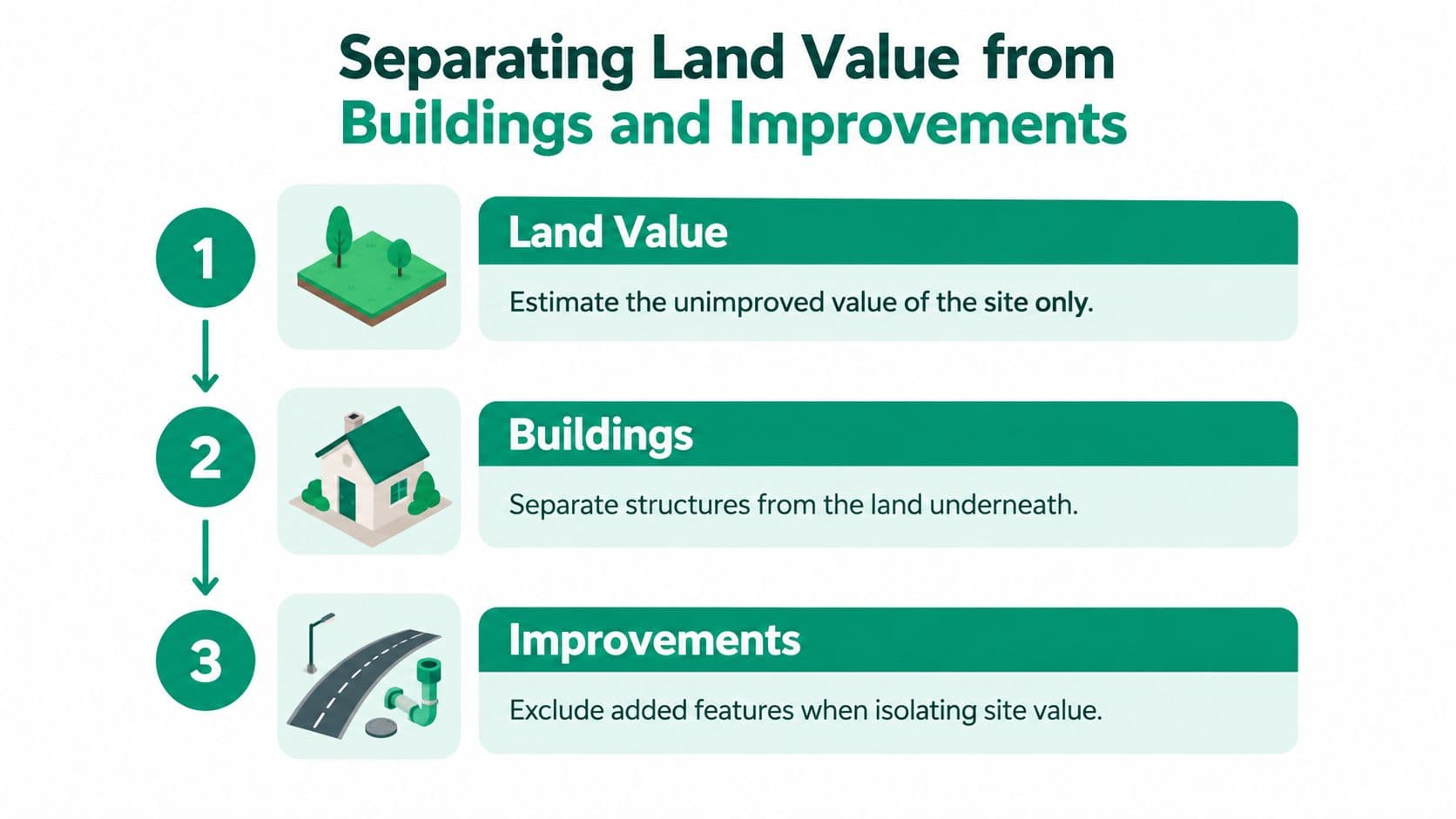
A house purchase works like buying a bundle. The payment covers a location, a structure, and added features. To estimate site value, the assessor must separate those components rather than assume the whole purchase price represents land.
Land zonal value concerns the unimproved site, separated from buildings and other improvements. "Unimproved" doesn't mean pretending the surrounding town has disappeared. The task is to distinguish the location's value from the value attributable to privately created structures and features.
That boundary is itself an estimate, and it deserves honest treatment. Drainage work, grading, and mature landscaping sit awkwardly between "site" and "improvement," and reasonable assessors will draw the line differently. A documented record of where the line falls matters more than pretending the line is obvious.
Why the distinction changes the tax base
A pure land-value tax applies to the site's value. A conventional property tax generally combines land and improvements. The difference is the object being assessed, not the name printed on the bill.
Keep that distinction separate from tenure. A tax is a public charge; a lease or continuing land-use right concerns the terms under which someone occupies land.
Classification also does real work here. The difference between real and personal property is a useful companion question when deciding what belongs in the assessment record, because a misclassified item can shift value between categories without changing anything on the ground.
An idea with a long history
The idea of taxing site value has a long pedigree in public finance, though different writers have defended it for different reasons. Henry George popularized it in Progress and Poverty, published in 1879, emphasizing the contribution of surrounding population, public infrastructure, and community activity to site value, as the Lincoln Institute's historical account of land-value taxation describes.
That history establishes a long-standing fiscal instrument, not proof that every modern assessment is accurate. The difficult administrative question remains: how much of an observed property price belongs to the site?
A useful working distinction is:
- The location: Access to surrounding opportunities and community-created advantages.
- The building: The structure placed on the site.
- Other improvements: Added features that must be identified consistently.
Getting those boundaries right matters more than choosing a polished label for the valuation model. Each boundary decision should be documented, because disputes about land assessments often turn on exactly where the assessor drew the line.
Calculating and Mapping Zonal Land Values
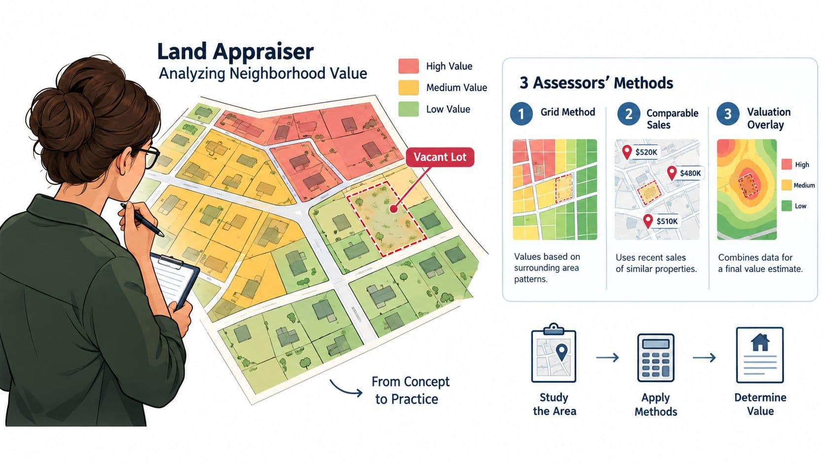
Assessors would have a simpler task if comparable vacant sites sold regularly under clearly understood conditions. When that evidence is scarce, they must infer land value from other information.
Think of separating food from service in a restaurant bill. You could subtract an estimated service cost, apply a typical food share, or compare many bills to estimate what each component contributes. Land assessment involves similar logic, but with much more consequential assumptions.
Choosing an estimation method
Residual extraction begins with the developed property's value and subtracts an estimate for buildings and improvements. The remainder is assigned to land. Its weakness is straightforward: an error in the improvement estimate affects the residual.
With allocation, the assessor assigns a typical land share to a property's total value. It's easy to explain, but a typical share may fit some properties poorly. A modest building on a desirable site shouldn't automatically receive the same treatment as a substantial building elsewhere.
Regression-based contribution analysis uses patterns across property records to estimate the contributions of different characteristics. It can accommodate more information, but the analyst still chooses the variables, comparison groups, and assumptions. A complicated model doesn't excuse an unclear explanation.
These approaches should be evaluated against the evidence available locally. A department can use an overview of mass appraisal methods to organize that choice without assuming one technique suits every parcel.
Moving from records to a published map
A practical municipal workflow should make each transformation visible:
- Assemble the records: Connect parcel identifiers, transaction records, valuation rolls, boundaries, and relevant site characteristics.
- Check comparability: Separate vacant and developed observations, and investigate sales that may not represent ordinary market conditions.
- Estimate parcel values: Apply the chosen method consistently and record adjustments rather than hiding them in manual overrides.
- Propose zones: Group sites with similar value drivers, then examine parcels near boundaries.
- Publish the benchmark: Explain the unit of measurement and how the benchmark translates into an individual assessment.
Before excluding unusual transactions, analysts can compare outlier identification methods through digna's resource. An outlier deserves investigation, not automatic deletion. It might reflect a data error, an unusual transaction, or a genuine difference the model hasn't captured.
The key control is traceability. An assessor should be able to move from a mapped benchmark back to the records, adjustments, and methodological choices that produced it. Without that trail, a map is difficult to maintain and even harder to defend.
Keeping Zonal Estimates Transparent and Defensible
A zonal value works more like a weather forecast than a surveyed boundary: useful for planning, risky to treat as exact down to the last dollar. The method can move the estimate. A 2025 FHFA working paper using parcel and transaction records in Maricopa County found that two reasonable routes to developed-parcel land value can diverge, partly because subdivision effects are hard to observe. The uncertainty is the same issue examined in methods for valuing land for real property taxation: even a careful model can leave a wide band of plausible values, so a rate per square meter should be published as an estimate with assumptions attached.
Taxpayers often ask whether the number is precise. The more useful test is which assumptions must hold for it to fit a parcel.
A public explanation should read like a receipt for a purchase. It should state the valuation date, the lawful uses assumed, whether infrastructure is already available or only expected, which comparable sales qualified, how adjustments were made, and which uncertainty range is shown with a plain-language meaning. An interactive tool such as explore a location-value map can help residents see how location relates to value, while the assessment file still has to show the evidence behind each zone.
Take a parcel inside a zone of serviced sites but with weaker access. The owner should be able to ask a narrow question: does the benchmark assume access this parcel lacks? The authority should answer with the record, the adjustment rule, and the calculation, and it should offer a route to fix a mistaken record.
A challengeable estimate is more useful than a precise-looking figure whose assumptions nobody can inspect.
Transparency cannot promise a particular legal outcome. It gives administrators a consistent trail and gives owners a fair chance to spot the wrong assumption before it hardens into a bill.
Policy Uses and Fiscal Risks in Practice
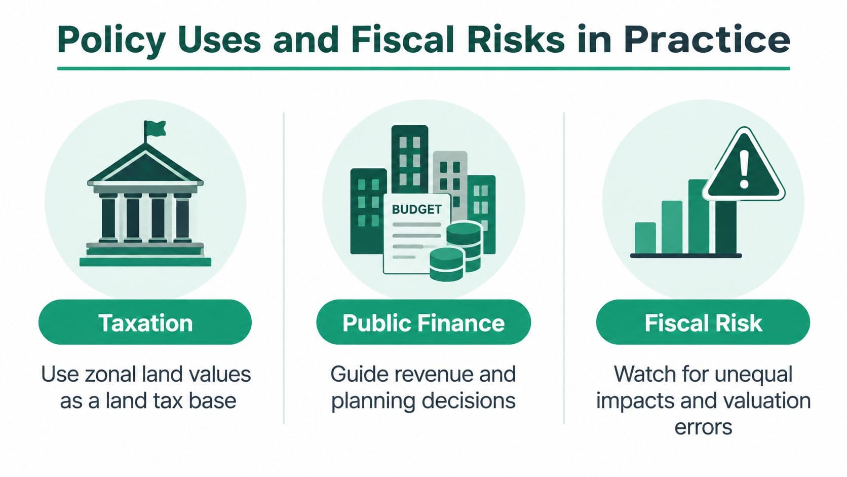
A finished zonal map can look like settled truth. Treat it like a weather forecast instead: specific enough to plan around, uncertain enough to recheck before spending the money. A treasurer, an infrastructure team, and planners may read the same map, but they are answering different questions.
Taxation asks how much revenue a land base can support. Value capture asks how much location-created gain can be recovered for public purposes. Planning analysis asks where serviced land, demand, and constraints point to likely development. A value that is adequate for one use can still be too weak for another, so the assumptions behind each zone should travel with the estimate.
Stress the revenue line before promising it
The core fiscal risk is simple: land remains in place while its price can move faster than the budget. The FHFA analysis of land values and tax revenue reports that a hypothetical land-value tax for Maricopa County had an estimated sensitivity of 3.3 to national house prices, compared with 2.3 for property-tax revenue, and that by 2018 housing values had recovered 96% of their 2007 level while land values had recovered 66%. That is one county and one modeled tax, so it should not be read as a forecast. It is enough to warn a finance team against budgeting as if permanence meant stability.
Before recurring spending is tied to land receipts, test four safeguards in the budget model: reserves held from stronger periods, averaging that smooths abrupt assessment changes, rate adjustment with legal and distributional effects, and the behavior of land receipts beside other revenue. Each has a cost. Smoothing can postpone recognition of a real decline. Rate changes can move pressure onto owners who had no part in the forecasting error.
Match development charges to readiness
A higher holding charge can push owners to decide, but it cannot create sewer capacity, road access, or planning certainty. If servicing is late or permitted use remains unresolved, an owner may be waiting for conditions the valuation implicitly assumed were already present.
Model delayed-development cases alongside the rate: weaker demand, late infrastructure, appeal-driven revaluations, and parcels whose zone benchmark fits poorly. Phase implementation where possible, write hardship rules before the first bills, and publish which infrastructure assumptions sit inside each zone.
A land policy is safer when the estimate admits what it does not know and the budget is built to survive that uncertainty.
Comparing Land Leases, Land-Use Rights and Land-Value Charges
The choice of tenure changes when occupants face land-price risk. A fixed payment may look reassuring today while leaving a difficult adjustment for later.
In this comparison, land leases are renewable or non-renewable fixed-term agreements with a fixed price. Renewable leases provide certainty only until the term ends. At renewal, the accumulated gap between the lease rate and the market closes through a major repricing.
Non-renewable leases present a different problem. As the remaining term shortens, refinancing and selling become progressively harder. Fixed leases postpone risk rather than price it continuously.
Fixed Leases Compared with Land-Use Rights
| Feature | Fixed-term land lease | Land-use right |
|---|---|---|
| Duration | Limited term | Indefinite |
| Repricing | Fixed during the term | Repriced annually |
| Renewal | Required for renewable leases | No renewal required |
| Expiration | Ends unless renewed, where renewal is available | Does not expire |
| Transfer implications | Remaining term and renewal conditions matter | Low-cost transfer is part of the intended design |
| Main exposure | Deferred repricing or diminishing remaining term | Ongoing annual price adjustment |
Land-use rights, as defined here, resemble leases but have no expiration and are repriced each year. Annual repricing is intended to let people buy and sell the rights at low cost rather than pay a large capitalized land price. The design aims to price access to land appropriately without burdening entrepreneurship and other productive enterprises.
That doesn't mean the occupant has no risk. Annual payments can change. The distinction is that the adjustment happens regularly rather than being deferred to a renewal event.
Check the contract, not the label
Sometimes fixed leases are called land-use rights. The terminology doesn't change their substance. Reserve the term for arrangements that meet all these conditions:
- Annual repricing: The price is reassessed each year.
- No renewal requirement: Continued tenure doesn't depend on securing another term.
- No expiration: The right is indefinite.
A land-value charge belongs in a separate category. It describes a payment assessed against land value, not an instrument that by itself grants tenure. Officials must specify who holds the underlying rights and how the charge interacts with them.
Unitism® is one advisory option for governments considering these choices. Its tri-factor economics framework separates labor, capital, and nature, and its services include valuation methods, site-value taxation design, fiscal modeling, cadastre integration, and civil-servant training.
A review of transition requirements can help officials identify the legal, administrative, and educational work needed before changing existing arrangements. The immediate task is to choose an instrument whose pricing rules match the policy purpose, then explain those rules plainly.
Taking the Next Step Toward Zonal Valuation Reform
Start with an administrative scoping exercise, not a revenue target. A ministry or city needs to know whether its legal powers, records, and staffing can support a credible assessment system before announcing a charge.
The first actions should produce tangible decisions:
- Confirm the legal basis: Establish authority to distinguish land from improvements and identify the rights being valued.
- Audit available evidence: Examine parcel records, transaction coverage, valuation rolls, and the ability to connect them reliably.
- Choose a suitable method: Match the approach to local evidence, especially where vacant-land sales are scarce.
- Specify public disclosure: Require valuation dates, uncertainty ranges, assumptions, and an accessible appeal route with the published map.
Set implementation conditions before setting rates
Require the finance and planning teams to test revenue volatility and land-use timing together. A projection that assumes rising values and immediate development won't reveal how the system behaves under difficult conditions.
Then assess who would face changed payments and when. Phase the transition where appropriate, define hardship rules, and assign responsibility for maintaining the records.
The most useful starting document is a short decision note identifying the proposed valuation framework, unresolved data problems, fiscal scenarios, and implementation responsibilities. Give each unresolved question an owner before moving to rate design.
A credible land zonal value system is an ongoing assessment process, not a finished map. Proceed when officials can explain the evidence, administer adjustments, and respond consistently when taxpayers identify mistakes.
Unitism® offers valuation frameworks, distributional and fiscal impact modeling, and implementation support for land-based reform. Visit Unitism® to begin a scoping conversation about your parcel data, proposed valuation approach, and the safeguards needed before implementation.