Compare methods of land valuation, their data needs, strengths, limitations, and implementation guidance for valuers, policymakers, and public agencies.
October 20, 2026
Methods of Land Valuation for Better Public Decisions
Compare methods of land valuation, their data needs, strengths, limitations, and implementation guidance for valuers, policymakers, and public agencies.

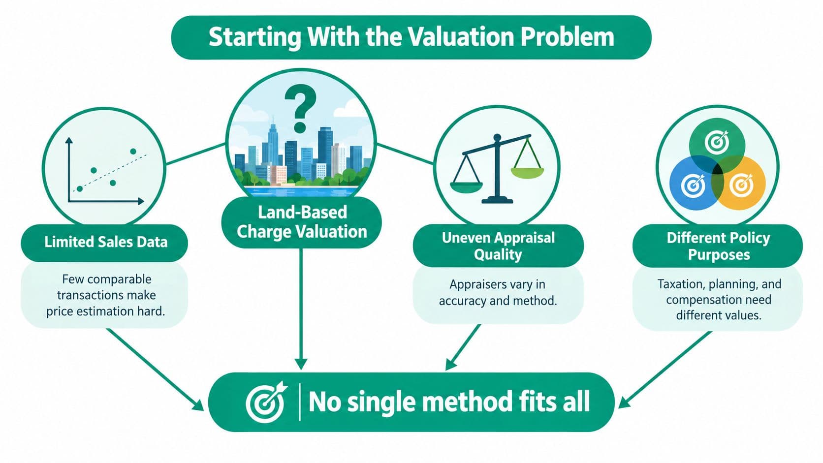
Your city wants to introduce a land-based charge, and you've been asked to defend the valuations behind it. The transaction file is thin, neighboring appraisers disagree, and the planning team wants values that reflect development potential while the finance team needs an administrable revenue base. Choosing a formula won't resolve those differences. You need an evidence standard, a clear definition of value, and a process residents can challenge.
Table of Contents
- Starting With the Valuation Problem
- Core Concepts and Evidence Hierarchy
- Categories of Land Valuation Methods
- Sales Comparison and Site-Value Methods
- Income and Residual Methods
- Hedonic and GIS-Based Spatial Models
- Choosing a Method for the Parcel and Purpose
- Mass Appraisal, Uncertainty, and Public Accountability
- Land-Value Taxes, Leases, and Use Rights
- Implementing a Defensible Valuation Program
- Glossary and Cross-References
Starting With the Valuation Problem
Consider a hypothetical municipality assessing an established commercial district, an undeveloped fringe, and a neighborhood with few recent sales. Officials could apply a uniform calculation across the map, but uniform arithmetic wouldn't make the underlying evidence comparable.
The commercial district might offer useful income records. The fringe might depend on uncertain planning assumptions. In the neighborhood, most transactions might combine buildings and land, leaving the site component unobserved.
Start by deciding what the authority needs to estimate. A property's sale value, a site's annual rental value, a statutory tax base, and compensation for displaced occupants aren't interchangeable outputs. Nor should officials assume that an estimate of market value captures ecological or cultural importance.
Set the decision before requesting the number
Ask the commissioning team to specify:
- The subject: Identify the parcel, interest, and improvements included or excluded.
- The purpose: Distinguish revenue administration from acquisition, compensation, investment, or planning.
- The acceptable uncertainty: State how much evidential weakness the decision can tolerate and who must review exceptions.
Then ask what evidence could contradict the proposed estimate. If the valuer can't answer, the authority is commissioning an opinion without a meaningful test.
The most useful methods of land valuation connect a defined question to observable evidence and documented assumptions. My recommendation is to commission a valuation protocol, not a schedule of parcel values. Require staff to explain why they selected a method, what information they lacked, and what would trigger reassessment before anyone relies on the result.
Core Concepts and Evidence Hierarchy
A defensible instruction needs a shared vocabulary. Otherwise, departments can agree on a figure while disagreeing about what it represents.
- Value date: The date to which the estimate relates, not necessarily the report's publication date.
- Market value: An estimate of exchange value under the specified market conditions and valuation assumptions.
- Site value: The value attributed to land under an explicit treatment of buildings and other improvements.
- Highest-and-best use: The legally permissible, physically possible, financially feasible use supporting the greatest value.
- Tenure: The ownership or occupation rights being valued, including restrictions and contractual obligations.
- Vacancy: Whether land or premises are unoccupied, which mustn't be confused with an assumption that land is unimproved.
- Arm's-length transaction: A transaction between independent parties rather than one shaped by a special relationship.
- Comparable parcel: A property sufficiently similar to inform the subject estimate after justified adjustments.
- Improvement value: The contribution attributed to buildings and other constructed additions.
Rank evidence before ranking methods
Completed transactions deserve priority over asking prices. Recent evidence and active, transparent markets deserve greater weight than stale observations or opaque dealings, consistent with the valuation principles addressed in Florida's real-property appraisal guidance.
Use that principle to organize the file. Begin with verified sales of comparable rights, then examine relevant income evidence, improvement-cost evidence, and statistical interpretation. Keep unsupported professional judgment visibly separate from observed inputs.
This isn't an absolute ranking between every income record and every cost estimate. A verified rent roll may be more useful than a poorly matched sale. The operational question is whether the evidence measures the interest and use being valued.
Evidence rule: Don't let the apparent precision of a calculation exceed the credibility of its inputs.
Assessment terminology also deserves attention before residents compare official values with listing expectations. Royal LePage Brookside Realty provides a useful companion resource to help readers understand your property tax assessment. For public administration, explicitly document the relationship between the assessment basis and the value concept residents encounter in ordinary transactions.
Categories of Land Valuation Methods
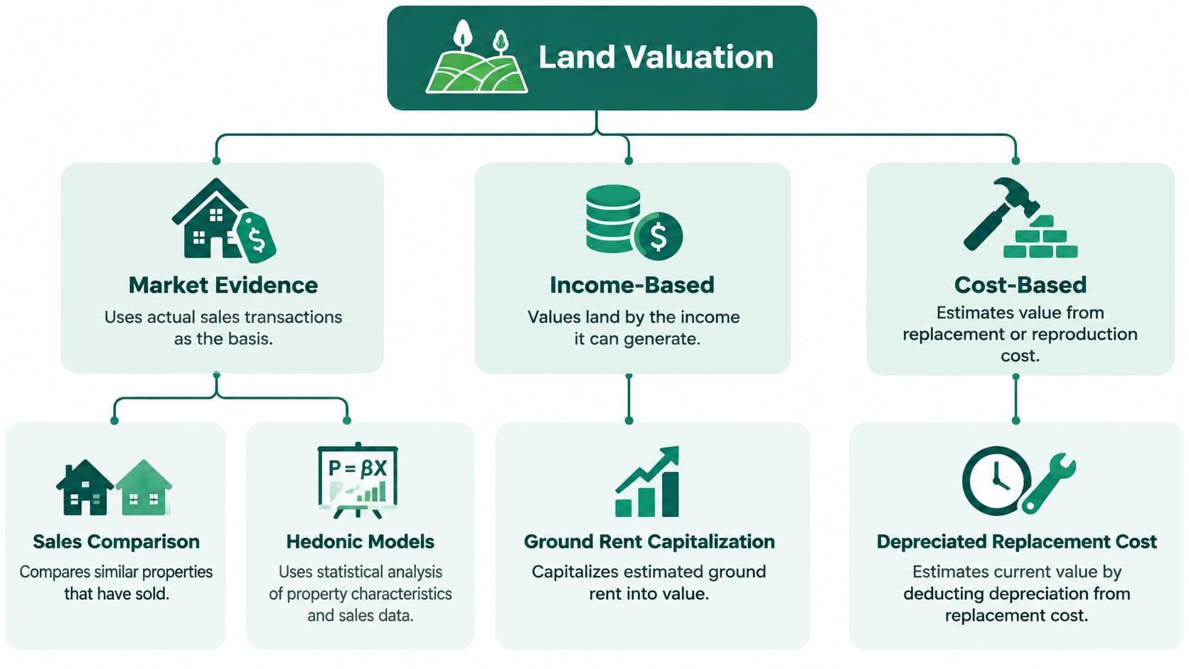
Modern real-property valuation uses sales comparison, income capitalization, and cost as complementary approaches, as described in New York's guidance on property valuation. For land, the practical task is to identify which approach supplies direct evidence and which helps separate or test components.
Match each family to its question
- Market evidence: What have buyers paid for comparable interests? Sales comparison uses verified transactions and parcel characteristics to estimate an exchange value.
- Income evidence: What is the relevant earning capacity worth today? Capitalization uses income and return assumptions to estimate a capital value.
- Development evidence: What remains for land after delivering a feasible project? Residual analysis uses completed-property value and project expenditure assumptions.
- Cost and allocation evidence: How should an improved property's value be separated? Cost analysis estimates improvement value, while allocation applies an evidenced relationship between land and total property value.
- Location-sensitive analysis: How do attributes and geography relate to observed prices? Hedonic models estimate relationships, while geographic information systems organize and display spatial evidence.
Abstraction belongs beside these separation techniques: the valuer deducts estimated improvement value from an improved property's sale price. Don't confuse that exercise with a development residual, which concerns a proposed or completed development's economics.
Use disagreement diagnostically
The cost approach doesn't create bare-land value by adding up expenditure. In its conventional application, the valuer estimates depreciated improvement cost and adds a separately estimated land value.
Likewise, a map is not an independent valuation because it displays a different color for every parcel. Ask what evidence generated the mapped values.
Triangulation is useful only when the checks add information. Running several calculations from the same unsupported development assumption doesn't provide independent corroboration. Where approaches diverge, investigate the use assumptions, input quality, and treatment of improvements before reconciling the conclusions.
Sales Comparison and Site-Value Methods
Use sales comparison as the primary method for individual nonagricultural parcels when adequate comparable sales exist. The IAAO Standard on Mass Appraisal of Real Property identifies that preference and recognizes alternative land methods where direct evidence is limited.
The work starts before adjustment. Verify what transferred, whether the parties acted independently, when the transaction occurred, and whether the recorded consideration includes anything beyond the land interest under review.
Normalize the transaction, then explain the differences
Choose a unit that reflects how buyers assess the relevant land. Depending on the market, that could be price per square metre, hectare, frontage, permitted floor area, or development capacity.
A convenient unit isn't automatically an appropriate one. Comparing development sites only by surface area can obscure differences in the development each site is permitted to accommodate.
For a hypothetical comparison, consider a raw-land sale with direct road access and another requiring access works. Suppose their zoning also permits different development intensity. The valuer should align the measurement basis and document adjustments rather than treat the observed unit prices as interchangeable.
- Location and access: Explain the relevant differences and the evidence supporting their treatment.
- Planning and use: Separate existing permission from an expectation of future approval.
- Physical characteristics: Record configuration, terrain, servicing, and constraints relevant to the proposed comparison.
- Rights and timing: Align tenure and transaction date with the valuation instruction.
Keep the adjustment trail visible
For each comparable, show the original evidence, the reason for inclusion, the adjustment rationale, and its influence on the conclusion. If an adjustment rests mainly on judgment, say so.
Vacant raw-land sales are particularly useful because the valuer doesn't first have to separate buildings from the transaction. That advantage disappears if the vacant sites have materially different permissions or market contexts.
For readers familiar with residential pricing, David Beshay Real Estate on CMAs offers an accessible companion explanation of comparative market analysis. A public land assessment still needs a documented, land-specific selection and adjustment protocol.
A nearby transaction is a candidate comparable, not proof of comparability.
Sparse sales require restraint. Geographically clustered sales require it too: a concentration of observations in a desirable district shouldn't determine values elsewhere without a justified adjustment process.
The final site-value estimate must remain tied to the parcel's specified characteristics and rights. Don't turn a parcel-specific conclusion into a wider policy measure of community benefit or development desirability.
Income and Residual Methods
An occupied commercial parcel and an undeveloped housing site may both lack useful vacant-land comparables. They still present different valuation problems. For the commercial parcel, the relevant evidence may be earnings; for the development site, it may be the economics of a feasible project.
Capitalize the appropriate income
In simplified form, capital value equals net operating income divided by a capitalization rate. Income capitalization is relevant to income-producing commercial land, agricultural property, and leased land.
The key word is appropriate. A valuer shouldn't capitalize the income from an entire improved property and label the result land value without separating the contributions involved.
Ground-rent capitalization focuses on the income attributable to the land interest. Before applying it, inspect the actual contract, the interest being valued, and the relationship between contractual receipts and the income assumption used in the valuation.
For a hypothetical leased commercial site, I would ask the valuer to reconcile the rent evidence with the legal agreement and explain the selected capitalization rate. A mechanically applied rate isn't a substitute for understanding the cash flow.
Estimate the development residual
For a developable site, begin with a supported estimate of completed-property value. Deduct the expenditures and allowances necessary to reach that outcome:
- Physical delivery: Construction and site-improvement costs.
- Project execution: Financing, marketing, transaction costs, and other relevant expenditure.
- Developer return: An explicit profit and risk allowance consistent with the appraisal assumptions.
The remainder is the residual attributable to land. A practical explanation of residual land value can help decision-makers understand why the estimate depends on the whole project, not just the parcel.
For a hypothetical redevelopment site, require the appraisal to distinguish the currently permitted scheme from a scheme dependent on additional permission. Don't allow an optimistic planning outcome to become an undisclosed assumption in the official land figure.
Test the assumptions that matter
Residual estimates are sensitive to planning permission, absorption, discount rates, construction inflation, and required developer returns. Test plausible scenarios rather than publishing only the preferred case.
Show which assumptions change together. A slower delivery scenario, for example, should prompt a review of the financing and timing assumptions rather than an isolated edit to the sales schedule.
The advisory distinction is straightforward: income capitalization interprets earning capacity; development residual analysis interprets project feasibility. Neither should override credible comparable land evidence without explanation.
If the residual conflicts sharply with observed transactions, investigate the completed-value forecast and expenditure allowances. Don't resolve the discrepancy by adjusting developer profit until the answer looks convenient.
Hedonic and GIS-Based Spatial Models
A valuation map can look authoritative even when the supporting transactions are thin. Treat the display as a review instrument, not a certificate of accuracy.
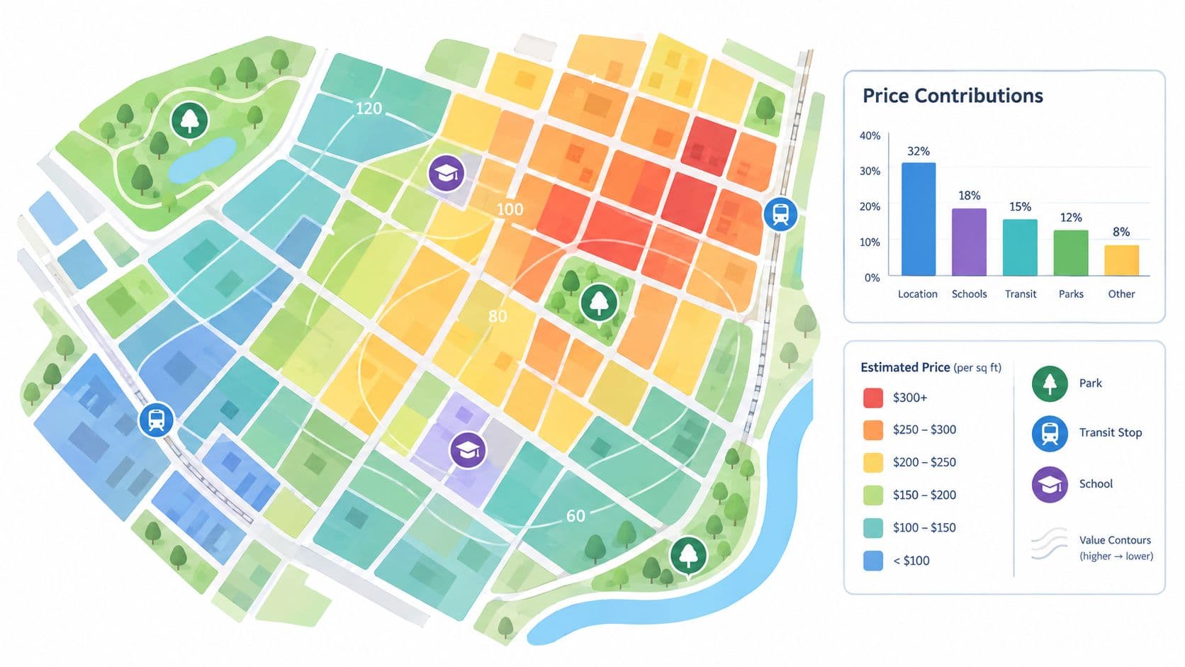
A hedonic model estimates how observed property prices relate to measurable characteristics. A GIS-based workflow organizes parcels, mapped attributes, and spatial relationships so analysts can investigate location and review valuation patterns.
Separate statistical estimation from mapping
In a hypothetical municipal exercise, analysts might relate verified sale prices to parcel size, access, permitted use, and neighborhood attributes. They could then use the estimated relationships to produce location-adjusted indications for unsold parcels.
The GIS team could display those indications alongside transaction locations, planning boundaries, and missing-data flags. That lets reviewers distinguish a pattern supported by observations from one largely inferred beyond the transaction area.
Require analysts to disclose:
- Model specification: Which variables were included, excluded, or transformed, and why.
- Coefficient interpretation: What each estimated relationship means within the model, without presenting association as proof of causation.
- Coverage limits: Where the model relies on comparable observations and where it extrapolates.
- Diagnostics: How reviewers tested errors, unusual observations, and systematic geographic differences.
Challenge attractive but fragile outputs
Nearby properties can share characteristics that the model doesn't measure adequately. Zoning can also overlap with location and development expectations, making a simple interpretation of an estimated coefficient misleading.
My recommendation is to review errors geographically as well as statistically. Ask local staff to examine unexpected boundaries, abrupt value changes, and apparently similar parcels receiving dissimilar treatment.
These are model-review recommendations, not a claim that a particular software package resolves valuation uncertainty. The administrative standard remains understandable inputs, explainable outputs, and a documented correction process.
Spatial tools extend analytical coverage, not the supply of actual transactions. Where evidence is weak, show the weakness on the map. A smooth value surface should never conceal missing observations or unsupported assumptions.
Choosing a Method for the Parcel and Purpose
Choose the primary method according to the evidence most directly connected to the valuation question. Then choose corroboration that can expose a different kind of error.
Land valuation method selection matrix
| Method | Best evidence condition | Typical use | Main strength | Main limitation | Cross-check |
|---|---|---|---|---|---|
| Sales comparison | Verified, recent comparable sales | Vacant residential and nonagricultural sites | Direct transaction grounding | Weak matches require judgment | Relevant rent or residual evidence |
| Income capitalization | Reliable income and return evidence | Commercial, agricultural, and leased land | Connects value to earning capacity | Sensitive to income attribution and rate | Comparable land transactions |
| Residual | Supported project values and expenditure estimates | Development and redevelopment sites | Makes project assumptions explicit | Highly assumption-sensitive | Sales and alternative development scenarios |
| Hedonic | Consistent transactions and parcel attributes | Broad parcel estimation | Applies attribute relationships consistently | Specification and omitted-variable risks | Holdout sales and local review |
| GIS-based spatial models | Reliable parcel mapping and geographic attributes | Coverage analysis and location review | Makes geographic patterns inspectable | Mapping can disguise weak evidence | Transaction overlays and field checks |
| Cost-related land methods | Credible improvement-cost and depreciation evidence | Improved parcels with limited direct land evidence | Helps separate land and improvements | Separation errors affect land estimates | Vacant-land sales or income evidence |
Make the use assumption explicit
Before commissioning a development-based estimate, resolve the highest-and-best-use analysis. Ask whether the proposed use is supported by existing rights and feasibility evidence or depends on a speculative change.
For the established commercial parcel, prioritize the relevant income file. For the undeveloped fringe, require planning and infrastructure review before accepting development assumptions. For a jurisdiction-wide program, statistical tools may improve consistency, but individual exceptions still need scrutiny.
Property owners also approach valuation through consumer-facing services such as Christie's International Real Estate Puerto Rico home valuation resource. A public authority should explain why its land-only instruction may differ from a whole-property estimate.
Selection test: Choose the method you can defend with evidence, not the method that produces the preferred revenue forecast.
Specialist review is warranted when the result depends on contested rights, unusual improvements, uncertain permission, or a substantial gap between independently supported approaches. Don't average unresolved contradictions into a seemingly precise conclusion.
Mass Appraisal, Uncertainty, and Public Accountability
An authority can obtain plausible individual appraisals and still administer an inconsistent valuation roll. Public accountability requires comparable treatment across the population, not merely persuasive reports for selected parcels.
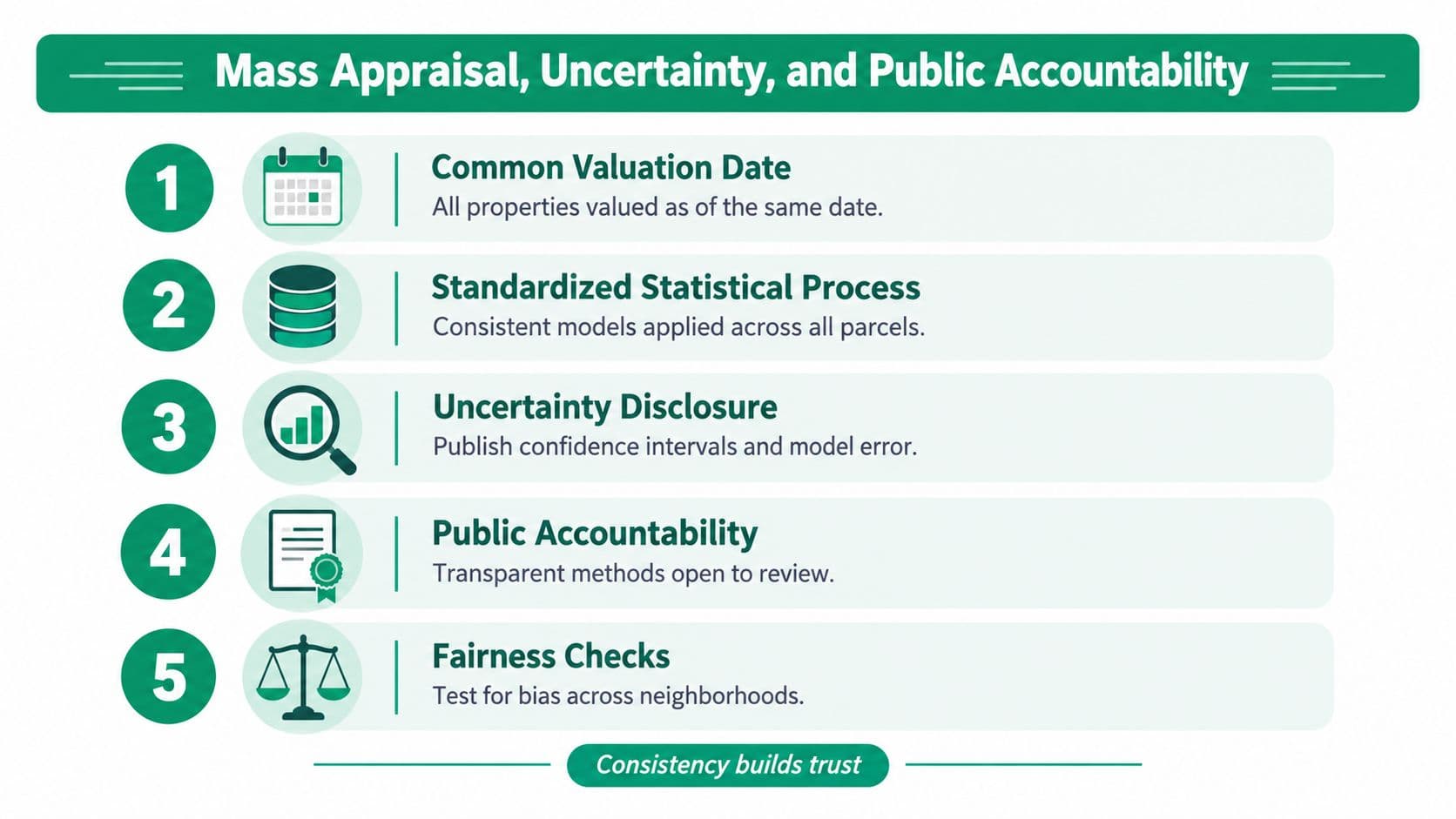
Massachusetts defines mass appraisal around a common valuation date, common data, standardized methods, and statistical tests, as set out in its mass-appraisal guidance. Comparable groupings and measurable characteristics let assessors apply a repeatable process rather than improvise parcel by parcel.
Audit treatment, not just overall fit
A useful review asks whether similar parcels receive similar treatment and whether errors concentrate in particular property classes or neighborhoods. A satisfactory aggregate result shouldn't excuse a systematic problem within a smaller group.
Use mass-appraisal methods as an administrative framework, then require a practical audit file:
- Selection rules: Publish why transactions qualify and how exclusions are reviewed.
- Uncertainty disclosure: Report defensible confidence or prediction intervals where the model supports them, explaining what they mean.
- Sensitivity testing: Show the effect of changes in capitalization and development assumptions.
- Exception handling: Identify sparse-data groups and parcels requiring manual review.
- Revision procedures: Record appeals, corrections, approvals, and the evidence behind each change.
Don't manufacture statistical confidence
A model-generated interval doesn't capture every source of uncertainty. Unrecorded tenure restrictions, incomplete transaction information, and an incorrect use assumption may sit outside the statistical calculation.
Residual land estimates deserve particular care because their interpretation depends on current or potential use. Officials shouldn't describe a calculated remainder as though they directly observed a separate transaction in that residual.
Reproducibility is the minimum administrative standard. Another competent reviewer should be able to reconstruct the estimate from the recorded data, rules, and assumptions.
Publish limitations in language residents can understand. Where transactions are opaque or geographically concentrated, identify the affected areas and the additional review applied. Acknowledging incomplete evidence is more credible than claiming uniform certainty that the authority can't substantiate.
Land-Value Taxes, Leases, and Use Rights
A land-value tax, a fixed-term land lease, and an indefinite annually repriced land-use right are different arrangements. Valuation supports each, but officials must specify whether they are setting a tax base, valuing a contractual interest, or determining a recurring payment for use.
A land-value tax places the charge on the defined land-value base rather than treating buildings as the source of that charge. It doesn't itself grant occupation rights or establish a lease term.
Fixed leases postpone repricing risk
For this policy comparison, land leases are renewable or non-renewable fixed-term agreements with a fixed price. Renewable leases provide certainty only until the term ends, when the accumulated difference between the lease rate and the market can close through a major repricing.
Non-renewable leases become progressively harder to refinance and sell as expiration approaches. Officials evaluating these arrangements should examine the end-of-term position, not just the apparent affordability of the initial payment.
Fixed leases don't correctly price risk through time. They postpone risk, concentrating consequences at renewal or expiry rather than keeping the land payment aligned through regular repricing.
Apply a strict definition of land-use rights
Land-use rights, in the policy model used here, resemble leases but are indefinite and repriced annually. They qualify only when they meet all of these conditions:
- Annual repricing: The land payment is reassessed each year.
- No renewal: Continued occupation doesn't depend on negotiating another term.
- No expiry: The right has no expiration date.
Annual repricing allows these rights to be bought and sold at low cost, unlike fixed-term leases. The intended economic distinction is that the recurring payment prices land appropriately without burdening entrepreneurship and other productive enterprises.
Sometimes officials call fixed leases “land-use rights.” Under this definition, they aren't: an expiring agreement remains a fixed lease, whatever its label.
For implementation, require legal documents and valuation instructions to use the same terminology. Keep the annual land-payment assessment separate from the valuation of privately created improvements, and make the repricing procedure transparent before introducing the arrangement.
Implementing a Defensible Valuation Program
Approve the operating specification before procuring a model. The commissioning document should identify the purpose, value concept, parcel population, valuation date, intended precision, responsible officials, and review arrangements.
Build an evidence inventory from transaction records, parcel boundaries, tenure information, planning permissions, improvement records, income evidence, and spatial attributes. For every dataset, record its origin, update process, missing fields, and known limitations.
Build and test the working system
- Clean before calibrating: Check parcel identifiers, duplicate transactions, missing rights information, and inconsistent measurement units.
- Assign comparable groups: Use characteristics relevant to the valuation question, with documented reasons for exceptions.
- Select primary evidence and checks: Record the method-selection decision for each group rather than leaving it implicit in software settings.
- Test unusual observations: Investigate outliers instead of automatically deleting them, and distinguish recording errors from genuine market evidence.
- Review difficult parcels: Flag unusual improvements, constraints, and weak geographic coverage for staff attention.
An address-based interface can help users locate a parcel, but it shouldn't replace the underlying record. Treat a land-value estimator by address as an access point whose assumptions and parcel match must remain inspectable.
Separate market estimates from policy judgments
Keep climate exposure, ecosystem services, displacement concerns, and social or cultural effects visible rather than burying them in an unexplained capitalization adjustment. The International Valuation Standards effective in January 2025 provide the relevant standards context for observable inputs, comparative analysis, and environmental, social, and governance considerations.
My recommendation is to report distinct layers: market land value, explicitly policy-adjusted value, and non-market impacts. Decision-makers can then see where a market estimate ends and a public judgment begins.
Before publication, run scenario tests, obtain staff review, and prepare plain-language parcel explanations. Establish an appeal route capable of correcting both data errors and disputed assumptions.
Phase deployment through a reviewed pilot, publish unresolved weaknesses, and assign responsibility for updates. Don't launch a permanent charging system on the assumption that someone will repair its valuation administration later.
Glossary and Cross-References
Allocation estimates a land component using an evidenced relationship between land and total property value. Abstraction deducts estimated improvement value from an improved property's transaction value. Use the categories discussion to distinguish these separation techniques from development analysis.
Capitalization rate is the rate used to convert an income measure into capital value. Land residual is the amount attributed to land after the specified project costs and allowances are deducted. For rents, consult “Income and Residual Methods,” then check the contractual distinctions under “Land-Value Taxes, Leases, and Use Rights.”
Navigate by the immediate task
- Comparable sale: A verified transaction selected for relevant similarity, not proximity alone. Use “Sales Comparison and Site-Value Methods” when reviewing market evidence.
- Hedonic model: A statistical estimate of relationships between observed prices and attributes. Consult “Hedonic and GIS-Based Spatial Models” for location analysis and model review.
- Mass appraisal: A standardized process for valuing groups of properties. Use the accountability and implementation discussions when administering a valuation roll.
- Site value: The land component under stated assumptions about rights and improvements.
- Vacancy: An occupancy condition that must be distinguished from the appraisal assumption of vacant land.
- Highest-and-best use: The supported use premise against which the valuation is developed.
Choose the next task by identifying the unresolved decision. If you're unsure what transferred, verify tenure; if the comparable evidence is weak, investigate alternatives; if residents can't reconstruct the result, repair the documentation before defending the number.
Unitism® offers land valuation assessments, data frameworks, policy design, and implementation support for public authorities considering land-based revenue reform. Visit Unitism® to discuss your parcel evidence, site-rental-value requirements, and the administrative steps needed for a defensible valuation program.