Explore scenario modeling software for land-value reform. Compare features, data inputs, evaluation criteria, and governance for smarter policy decisions.
August 17, 2026
Scenario Modeling Software for Land-Value Reform
Explore scenario modeling software for land-value reform. Compare features, data inputs, evaluation criteria, and governance for smarter policy decisions.

A finance minister has promised lower taxes on work, more housing, and a balanced budget. The speech is over, but the hard part is just starting. The ministry's spreadsheet contains vacancy assumptions, construction timelines, land valuations, migration estimates, and borrowing costs, yet each input could move in several directions. A single forecast can't show whether the reform survives those changes.
That's the practical case for scenario modeling software. It gives policy teams a controlled decision room where they can compare plausible futures, trace assumptions, test distributional effects, and identify which choices create fiscal or political exposure. For land-value reform, that discipline matters because the same policy can affect public revenue, housing supply, asset prices, household cash flow, and local government budgets at once.
Table of Contents
- Why a Finance Minister Suddenly Needs Scenario Modeling Software
- What Scenario Modeling Software Does
- Core Features That Matter for Reform
- Land Leases Versus Land-Use Rights and Why the Difference Changes the Model
- Data Inputs and How Platforms Plug Into Cadastral Systems
- Procurement Criteria That Separate Real Platforms From Demos
- Governance, Workflows, and Public-Facing Visualizations
- Practical First Steps for a Reform Team
Why a Finance Minister Suddenly Needs Scenario Modeling Software
A minister facing tax reform doesn't need another dashboard. They need answers to questions such as:
- If payroll taxes fall, can land-based revenue replace the lost receipts during the transition?
- If assessments rise in high-demand districts, which households and businesses face higher charges?
- If exemptions are too generous, does the reform fail to capture the value created by public infrastructure?
- If housing construction responds slowly, how long does the budget carry transitional pressure?
Those questions involve multiple linked assumptions, not one forecast line. The revenue forecasting models resource is useful background, but a reform team still needs a model that connects revenue mechanics with land values, development behavior, and household impacts.
Start with the decision, not the software
The minister should write one decision statement before procurement begins. For example: “Which transition path can reduce taxes on work while maintaining public services and protecting households with limited cash income?” That sentence defines the scenarios, the outputs, and the evidence required.
Next, the team should separate policy variables from external conditions. A land charge, exemption, phase-in rule, or assessment frequency is a policy variable. Construction activity, interest rates, population movement, and vacancy are external conditions. The model should let analysts change both without rebuilding the structure.
Finally, the ministry should define the political test. A scenario that produces strong aggregate revenue but creates concentrated hardship in particular neighborhoods isn't ready for a ministerial decision. The platform must show who pays, who benefits, when the effects appear, and which assumptions drive the result.
Practical rule: If the team can't explain a scenario to a skeptical legislator without opening the model, the model isn't decision-ready.
Scenario modeling is therefore not a luxury analytics purchase. It's infrastructure for making a reform promise testable before legislation turns assumptions into obligations.
What Scenario Modeling Software Does
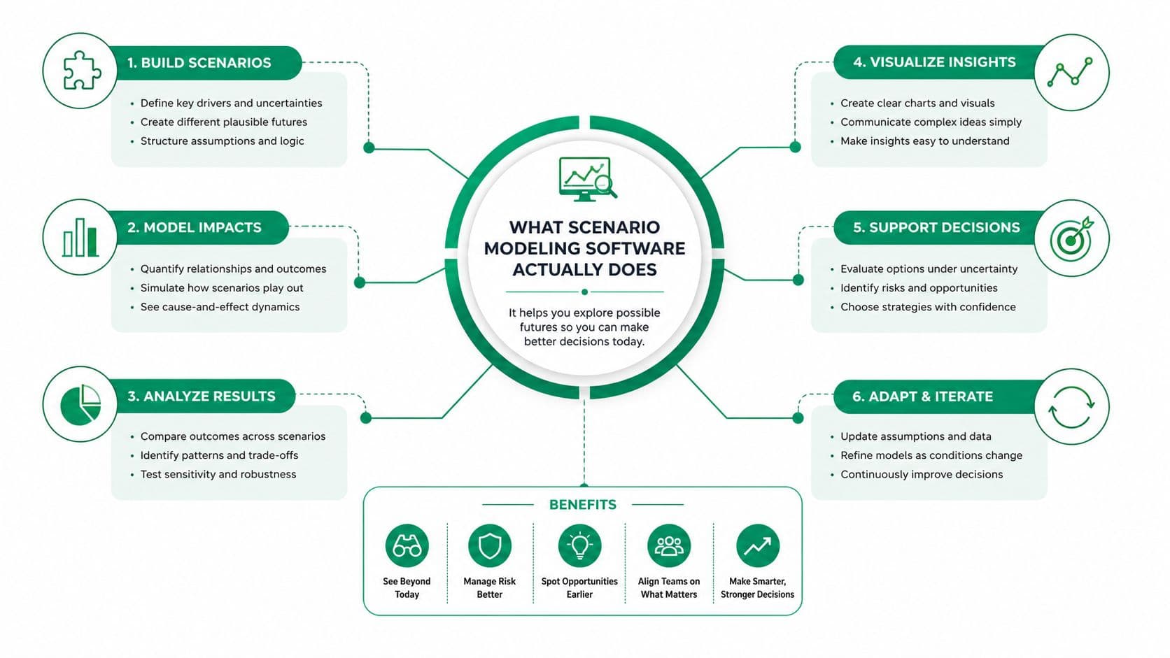
Scenario modeling software lets a policy team build, run, compare, and audit several internally consistent futures for one system. That makes it different from a dashboard, which reports an observed or projected state, and from an isolated spreadsheet, where assumptions can change without a dependable version trail.
The platform should function like a controlled policy laboratory. Inputs can include parcel records, tax bases, construction costs, demographic assumptions, and macroeconomic conditions. Rules and equations connect those inputs to outputs such as public revenue, housing affordability, land-use change, emissions, debt, and distributional tables. For land-value capture, the model must show how a shift from fixed land charges or lease arrangements toward annual collection affects both public finances and development decisions.
The difference between calculation and decision support
A spreadsheet can calculate a land charge. A scenario platform must also show what changes when officials adjust the valuation base, exemption, collection rate, or transition schedule. It should preserve the previous version, identify changed inputs, and let another analyst reproduce the result.
Public-sector finance illustrates the distinction. The Congressional Budget Office's interactive tools let users define alternative economic scenarios and compare revenues, outlays, deficits, and debt with the agency's 10-year budget projections. A separate simplified tool models discretionary budget authority and outlays across the same horizon. Its technical value comes from the causal chain. Changed assumptions propagate through budget identities into fiscal outcomes. UrbanSim's overview of scenario modeling explains how the same logic applies to public planning.
For reform teams, auditability is a governance requirement. Officials need to defend the assumptions behind a land-value charge, not merely present its final estimate.
Why dashboards and spreadsheets fall short
A dashboard may show that land values rose in a district. It will not necessarily show what happens if the city changes its assessment method, delays implementation, or returns revenue through public services. A spreadsheet may answer one version of that question, while copied files break formulas and obscure responsibility for changes.
Teams assessing related analytical categories can use this guide to compare predictive analytics platforms, while keeping prediction separate from policy simulation. A predictive system estimates likely outcomes. A policy model lets authorized users change rules and examine consequences under competing choices.
For land reform, connect valuation to fiscal, spatial, and distributional outputs. A plain-language guide to calculating land value gives nontechnical officials a foundation for reviewing those results.
Core Features That Matter for Reform
Evaluate each feature by the reform decision it supports. A polished interface is secondary to a model that exposes uncertainty, preserves an audit trail, and shows how annual land-value capture affects parcels, households, and public finances.
| Feature Module | Reform Question Answered | Risk When Missing |
|---|---|---|
| Scenario building | Which combination of rates, exemptions, and transition rules is workable? | Analysts compare disconnected cases that are not internally consistent. |
| Parameterization | Which policy levers can officials change without rebuilding the model? | Routine policy tests become consultant-dependent. |
| Sensitivity analysis | Which assumption most affects revenue or distributional outcomes? | Visible variables receive attention while hidden drivers dominate. |
| Monte Carlo simulation | How wide is the range of possible outcomes under uncertainty? | A single figure creates false confidence. |
| Spatial mapping | Where do land values, charges, and benefits concentrate? | National averages conceal neighborhood-level effects. |
| Fiscal and distributional outputs | Who pays, who gains, and how does the budget change? | Political objections arrive before the team can answer them. |
Build scenarios around reform choices
Scenario building provides the policy structure. Require a platform to support a base case, alternatives, and stress cases without treating any one outcome as inevitable. Parameterization should expose the land-value charge, treatment of vacant sites, relief for cash-constrained owners, and the pace of replacing taxes on work or buildings as editable inputs.
Those controls make the model useful during ministerial review and public negotiation. Officials can test annual repricing alongside different transition rules, then identify which choices protect productive activity while preserving land-value revenue.
Sensitivity analysis directs attention to the assumptions that deserve scrutiny. If small changes in assessment coverage produce large revenue differences, data quality becomes a political issue, not merely a technical one. The procurement team should require users to trace each result back to its assumption and source.
Replace false precision with distributions
Monte Carlo simulation matters where land values, construction responses, or collection rates are uncertain. The model draws from defined probability distributions and reports a range of outcomes instead of presenting one projected result. Many planning suites require add-ons or separate tools for stochastic simulation, so test this capability directly. Do not assume that a product labeled “scenario” includes it.
Spatial mapping supplies the local view needed for politically survivable reform. UrbanSim describes systems connecting land-use regulations and transportation investments with accessibility, housing affordability, greenhouse-gas emissions, open space, and sensitive habitats. That coupled approach fits land reform better than a calculator focused on a single variable.
Place fiscal results beside a clear distributional analysis framework, not in a later report. Revenue is only one result. The platform must identify winners, losers, timing, and available protections so officials can design relief openly and defend the transition.
Land Leases Versus Land-Use Rights and Why the Difference Changes the Model
Land pricing institutions determine what the model must represent. A land-value tax captures part of the rental value of land through taxation, but it isn't the same institution as a land lease or a land-use right. The model must distinguish the legal claim, payment schedule, renewal terms, transferability, and repricing mechanism.
A land lease is a fixed-term contract, either renewable or non-renewable, with a fixed price. Renewable leases offer certainty only until the term ends. If the lease rate falls behind the market, the accumulated gap can be closed in one major repricing at renewal. Non-renewable leases create a different problem. As expiry approaches, the asset can become harder to refinance and sell.
Fixed leases don't correctly price risk. They postpone it.
Land-use rights resemble leases in that they grant control over land without transferring the underlying natural resource, but the policy design described here treats them as indefinite rights with annual repricing. That recurring repricing keeps the payment closer to current land value and allows people to buy and sell the rights at low cost. It also avoids tying productive activity to a large maturity event.
The model architecture changes with the institution
| Regime | Payment pattern | Model requirement | Main exposure |
|---|---|---|---|
| Renewable fixed-term lease | Fixed until renewal, then repriced | Lease cohorts, expiry dates, renewal rules | Repricing cliff |
| Non-renewable fixed-term lease | Fixed until expiry | Maturity schedule, resale and refinancing assumptions | Declining marketability |
| Annual land-use right | Repriced regularly | Current land valuation engine and recurring payment flow | Valuation and governance quality |
China illustrates why legal categories must remain separate. Urban state-owned land-use rights are commonly granted for maximum terms of 70 years for residential land, 50 years for industrial land, and 40 years for commercial land. Jones Day's real-estate practice overview describes those fixed maximum terms. Chinese lease contracts themselves are capped at 20 years, with excess duration invalid and renewal available for up to another 20 years, as explained in this China lease agreement guide-20230228.pdf).
Public land leasing can also use long terms and renewal options to support financing and certainty. The Lincoln Institute notes that public land leases are typically longer than 50 years and often include multiple renewal options, which affects financing, resale, and long-term certainty. Its publication on public land leasing is useful when designing a transition, but a fixed lease still needs maturity cohorts. An annual land-use-right system needs a defensible valuation engine.
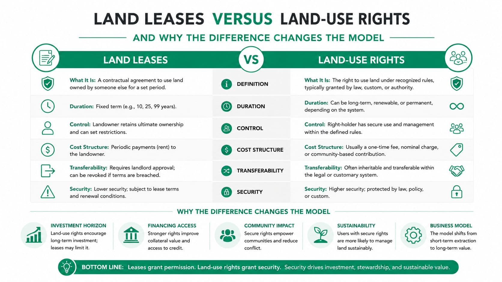
For a broader discussion of long-duration arrangements, see 99-year land leases, while keeping the distinction between fixed-term contracts and annually repriced rights explicit.
Data Inputs and How Platforms Plug Into Cadastral Systems
A scenario model is only as credible as its data lineage. The procurement team should begin with the parcel as the unit of analysis, then document how each source system contributes information and how the platform preserves historical states.
Cadastral parcels and ownership records identify the land. Tax rolls and assessment histories provide valuation benchmarks. Economic indicators, employment series, construction costs, transit access, zoning, hazards, environmental constraints, and development records help explain why land values and activity differ across locations.
Build a source map before building the model
Create a data register with five fields: source owner, update process, persistent identifier, permitted use, and scenario role. The authoritative cadastral system should remain distinct from scenario inputs. Analysts can copy a dated extract into a scenario, but they shouldn't overwrite the source record or make an untraceable manual adjustment.
A practical integration stack should support common open formats such as CSV and GeoPackage, along with OGC-compliant services where spatial layers are served dynamically. Persistent parcel identifiers matter more than visual map quality. Without them, the team can't reconstruct ownership, assessment, or land-use history reliably.
Questions for the integration workshop
- Can the platform preserve history? Ask whether a parcel's prior valuation and status remain available after an update.
- Can the platform separate facts from assumptions? A current tax roll and a proposed exemption should never look like the same kind of data.
- Can the platform export cleanly? Require usable outputs without conversion scripts or proprietary locks.
- Can it reconcile geography? Parcel boundaries, zoning layers, transport networks, and administrative areas must align without silent clipping.
- Can staff correct errors transparently? Every override should carry an owner, reason, timestamp, and approval status.
Data plumbing is often the largest implementation cost because public agencies inherit fragmented systems, inconsistent identifiers, and uneven data quality. The Kauai tax map key resource illustrates why parcel identification and map interpretation deserve attention before advanced simulation begins.
Procurement Criteria That Separate Real Platforms From Demos
A vendor demo is designed to make the product look effortless. An RFP should make failure visible. Buyers should require evidence, not assurances, and score the platform against the work of producing a defensible land-value reform scenario.
Eight tests for the RFP
-
Scalability. Can the platform run a national parcel dataset or a large metropolitan model without relying on one analyst's laptop? Require a test using the buyer's anonymized data structure.
-
Transparency. Can a non-author reproduce a published scenario from documented inputs, equations, and instructions? If not, the model remains a black box.
-
Auditability. Does every output link back to the input chain that produced it? Ask vendors to demonstrate an audit trail for a changed assessment or exemption.
-
Open formats. Can data leave the platform in standard formats without conversion scripts? Proprietary storage creates long-term bargaining risk.
-
User roles and permissions. Can analysts run experiments while only designated reviewers publish scenarios? A shared model without controlled publication invites confusion.
-
Visualization. Do maps, charts, and tables remain legible in a council meeting and understandable to residents? Require examples showing neighborhood-level fiscal and distributional results.
-
Calibration. Can the model be tested against historical revenue, assessments, transactions, and development patterns? A model that can't confront the past shouldn't dictate the future.
-
Documentation. Are equations, assumptions, data definitions, version history, and known limitations written down? Documentation is part of the control environment, not an optional manual.
A useful RFP should also specify acceptance tests, support responsibilities, migration rights, training, and exit conditions. Buyers seeking broader software development RFP advice should adapt that discipline to public modeling, where procurement must cover governance and reproducibility as well as delivery.
Procurement test: Don't ask whether the platform can model your reform. Give vendors one reform question, one sample dataset, and one publication deadline.
A platform that passes a scripted demo may still fail under staff turnover, source-data updates, or public scrutiny. The evaluation should therefore include an analyst who didn't build the model, a reviewer with no technical background, and a communications officer who must explain the result.
Governance, Workflows, and Public-Facing Visualizations
Technology gets a reform team to launch day. Governance determines whether the model remains trusted after assumptions change, officials rotate, or critics challenge the result.
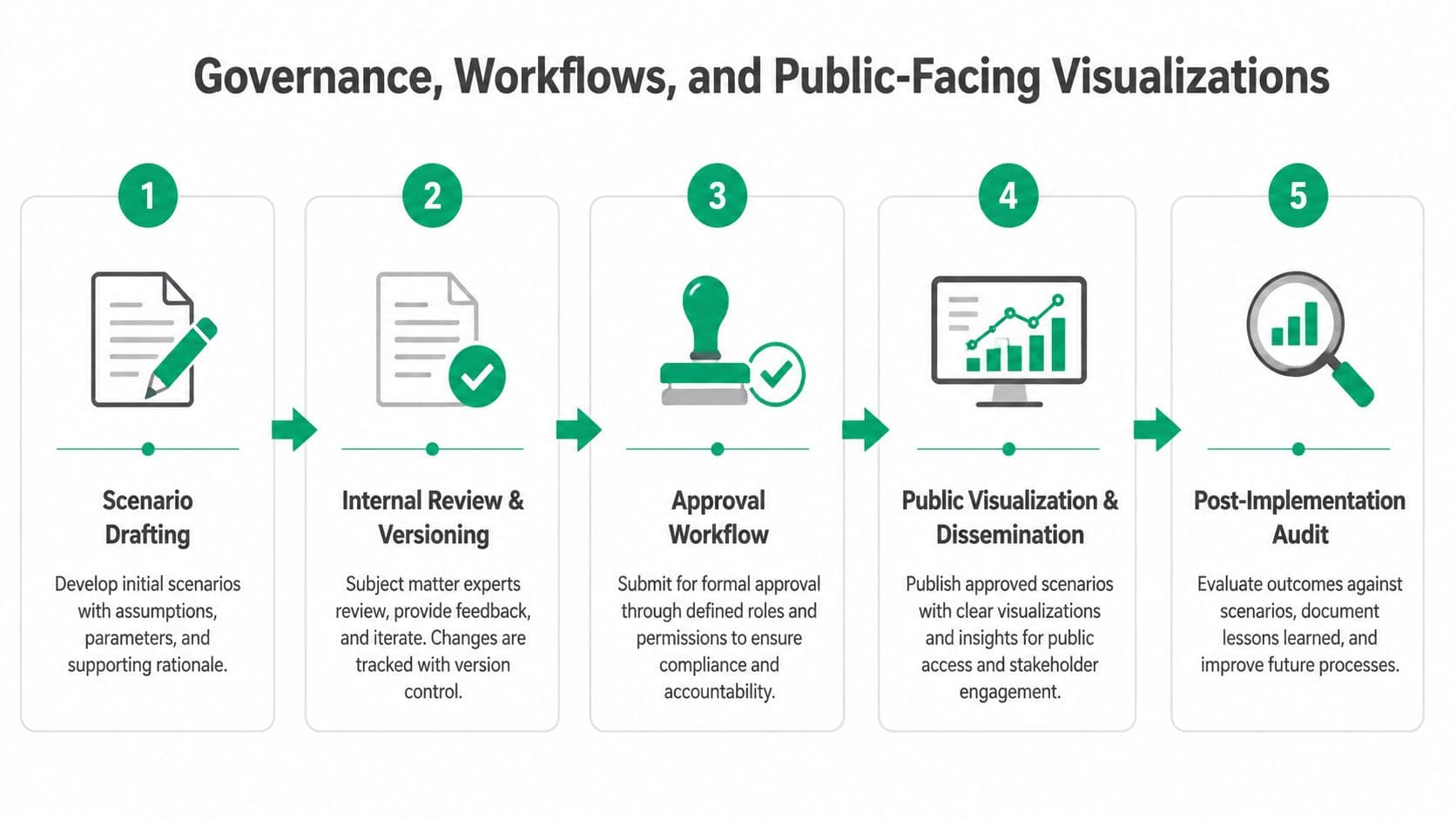
The agency needs a written scenario charter. It should name the model owner, data stewards, technical reviewers, approving officials, publication rules, and retention requirements. Each scenario should carry a version, date, purpose, input snapshot, change log, and approval status. Analysts can experiment freely in a controlled workspace, but draft outputs shouldn't appear on public dashboards by accident.
A workable publication workflow
- Scenario drafting. An analyst records the policy question, inputs, assumptions, and intended outputs.
- Internal review and versioning. A second analyst checks formulas, data lineage, and sensitivity results.
- Approval workflow. Named officials approve the scenario for briefing, consultation, or publication.
- Public visualization and dissemination. The agency releases understandable maps, tables, methods, and limitations.
- Post-implementation audit. Staff compare outcomes with the scenario, explain deviations, and update the model record.
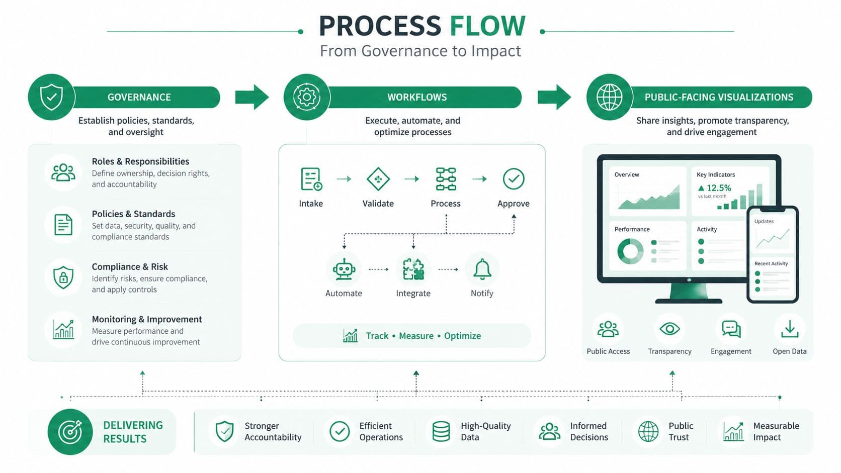
Public explanation is part of model control
Residents should be able to ask what a land-value reform means for their neighborhood without exposing confidential taxpayer information. That requires aggregation rules, privacy thresholds, plain-language definitions, and a clear distinction between observed values, modeled estimates, and policy assumptions.
Public-facing maps shouldn't hide uncertainty behind a single color scale. Show ranges where appropriate, explain what drives the range, and give users access to the underlying method. A transparent visualization can reduce suspicion, but only if the agency admits what the model can't know.
The workshop evidence summarized by Synario's municipal scenario planning material identifies trust, complexity, cost, data access, interoperability, and staff capacity as practical barriers. Some participants also flagged data availability, model integration, and trust as significant obstacles. Those aren't reasons to avoid modeling. They're requirements for the operating design.
Practical First Steps for a Reform Team
A finance ministry or city planning department can establish a credible foundation without waiting for a perfect national data platform. The first 90 days should produce a decision-ready pilot, not a sprawling technology program.
Days 1 through 30
Write one reform question that officials must answer by the end of the pilot. Keep it specific enough to test, such as comparing a fixed-term lease transition with an annually repriced land-use-right approach in a defined jurisdiction.
Then inventory the available cadastral, ownership, assessment, revenue, zoning, transport, and development data. Record gaps clearly. Decide which system is authoritative, which files are temporary, and where the versioned model of record will live.
Days 31 through 60
Select two contrasting platforms, one enterprise product and one open-source or highly configurable option. Run both against the same reform question and the same prepared dataset. Don't let vendors substitute a generic demonstration for the test.
Publish a glossary for ministers, council members, analysts, and residents. Define land value, site value, lease payment, land-use right, exemption, phase-in, incidence, revenue neutrality, and model uncertainty in ordinary language.
Days 61 through 90
Ask both pilots to produce the same outputs:
- Fiscal results: Revenue, transition effects, and public-service implications.
- Distributional results: Household, business, neighborhood, and tenure impacts.
- Spatial results: Maps showing where charges, benefits, and uncertainty concentrate.
- Governance results: Version history, approvals, data lineage, and export package.
- Stress results: Alternative assumptions and probability-based ranges where supported.
Choose the platform that staff can operate and defend, not the one with the most impressive interface. No software can decide the appropriate valuation method, legal treatment, relief design, or political sequence by itself. Those questions need professional judgment, public consultation, and administrative preparation.
Unitism® offers valuation assessments, land-value policy design, distributional and fiscal impact modeling, cadastral integration, training, and public-facing interactive tools for governments and organizations working through these choices. Visit Unitism® to connect scenario modeling with a practical land-value reform program.