Learn the smart growth principles shaping today's cities, from compact design to fair land policy, with practical steps for governments and planners.
August 19, 2026
Smart Growth Principles: A Practical Guide for Cities
Learn the smart growth principles shaping today's cities, from compact design to fair land policy, with practical steps for governments and planners.
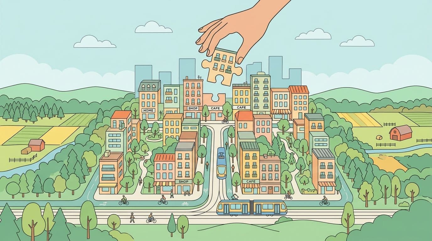
A city finance director opens the capital budget and sees the same pattern repeated across every projection. Roads extend farther from the urban core, water mains reach toward former farmland, and transit subsidies grow while the tax base remains scattered. The immediate question is where to find money. The deeper question is why the city keeps approving a pattern of growth that makes every new household more expensive to serve.
Smart growth principles offer a different answer. They guide development toward compact, walkable, mixed-use communities connected by several transportation options, while protecting open space and making public decisions more predictable. The approach isn't anti-growth. It asks cities to direct growth toward places where infrastructure, housing, jobs, and daily services can support one another.
That framework only works fully when governments also price land and access to public investment carefully. A dense neighborhood can still produce speculation, displacement, or weak public revenue if the underlying land system rewards holding sites idle or postponing risk. The planning principles and the pricing system need to reinforce each other.
Table of Contents
- What Smart Growth Is and Why It Matters
- The Ten Smart Growth Principles Explained
- What the Evidence Says About Compact, Mixed-Use Neighborhoods
- How Land Is Priced and Why It Changes Everything
- Implementing Smart Growth Through Land-Value Policy
- Case Studies From Cities and Countries That Tried It
- Common Pitfalls and How to Avoid Them
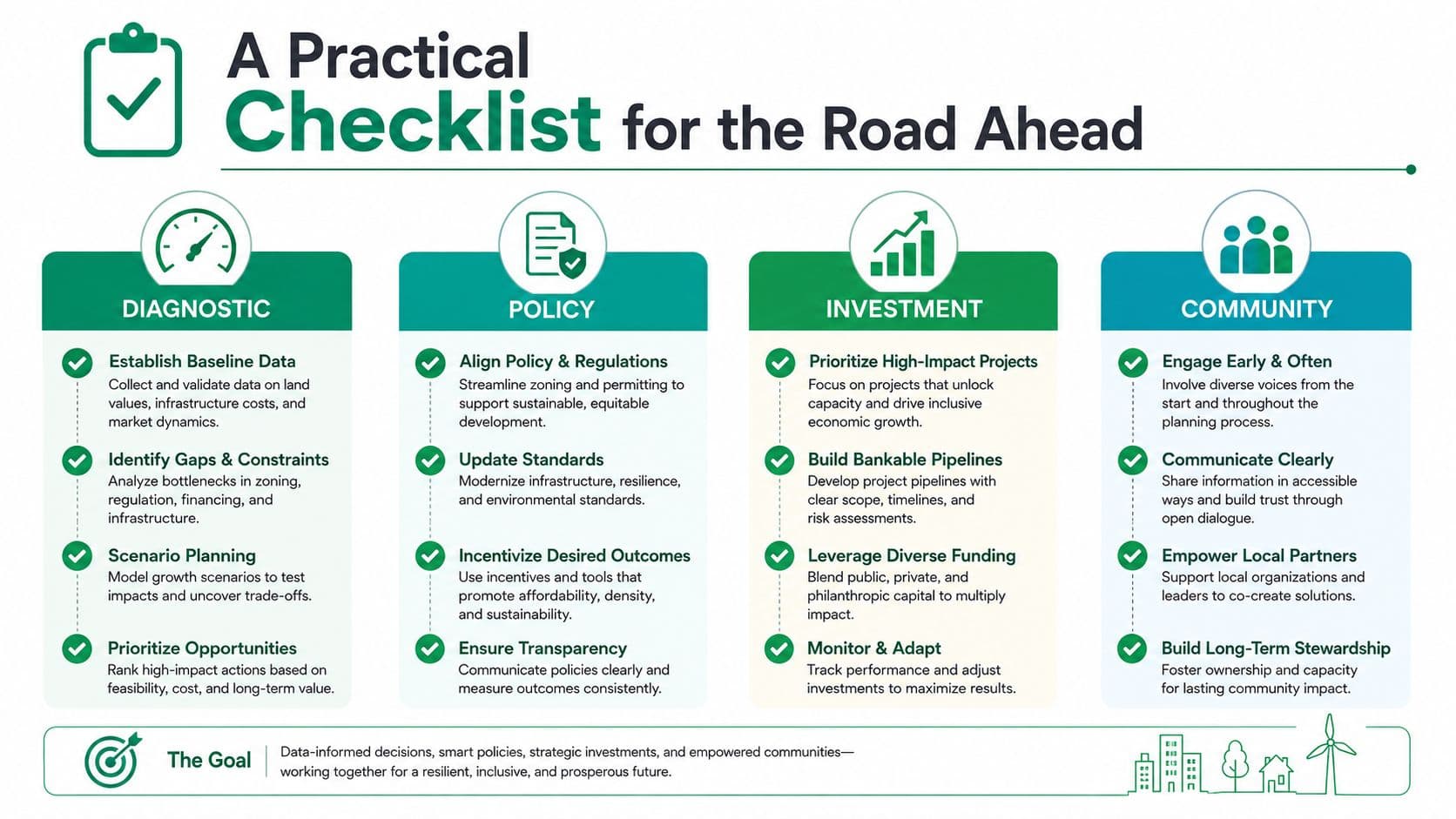
- A Practical Checklist for the Road Ahead
What Smart Growth Is and Why It Matters
A finance director comparing two expansion plans may see the same number of new households but very different public obligations. One plan extends roads, pipes, schools, and emergency routes across the metropolitan edge. The other places homes, services, and jobs near infrastructure already in use. Smart growth principles help cities decide where growth should occur and how it should be served, so development supports both daily life and public finances.
The framework took shape through the 1990s via the Smart Growth Network. The U.S. Environmental Protection Agency's account of smart growth identifies the network's recognition of these practices in 1996. Planning history also connects the movement with local growth management and new urbanism in the 1980s, state smart-growth legislation in the 1990s, and the federal Partnership for Sustainable Communities in 2009.
Why the fiscal problem comes first
Sprawl separates the location of development from the geography of public finance. A new subdivision can add property revenue, yet it also demands streets, water and sewer lines, emergency response, schools, maintenance, and eventual replacement. Serving a dispersed population leaves the city responsible for more network per unit of tax base.
Smart growth changes that equation by guiding more activity toward existing communities. Infill, compact buildings, connected streets, housing variety, and transit access can use land more efficiently, support more revenue per acre, and limit land, infrastructure, and public-service costs, as the EPA's economic-success materials explain.
Density alone cannot produce a successful neighborhood. Residents still need safe streets, welcoming public spaces, housing choices, reliable utilities, and fair access to jobs and services. A poorly designed high-density project may bring congestion and opposition instead of a functioning urban place.
Practical rule: Treat smart growth as a coordination system, not a density target.
The framework also protects assets that cities cannot easily recreate. Inward growth can reduce pressure on farmland, open space, and environmentally sensitive areas. Readers seeking visual examples of traditional street networks and neighborhood form can browse traditional neighborhood blueprints. A broader discussion of the positive aspects of urbanization connects urban concentration with access to services and economic opportunity.
Land pricing determines whether these plans endure. Public roads, transit, and zoning capacity can raise nearby site values. If the public captures none of that increase, owners may gain from public investment while residents continue paying its costs. Land leases, land-use rights, infrastructure sequencing, and land-value policy therefore need to work together. The lease determines who may use a site and under what terms, while the land-use right determines what activity is permitted. Pricing those rights carefully helps compact, walkable, mixed-use neighborhoods function as a durable public-finance strategy.
The Ten Smart Growth Principles Explained
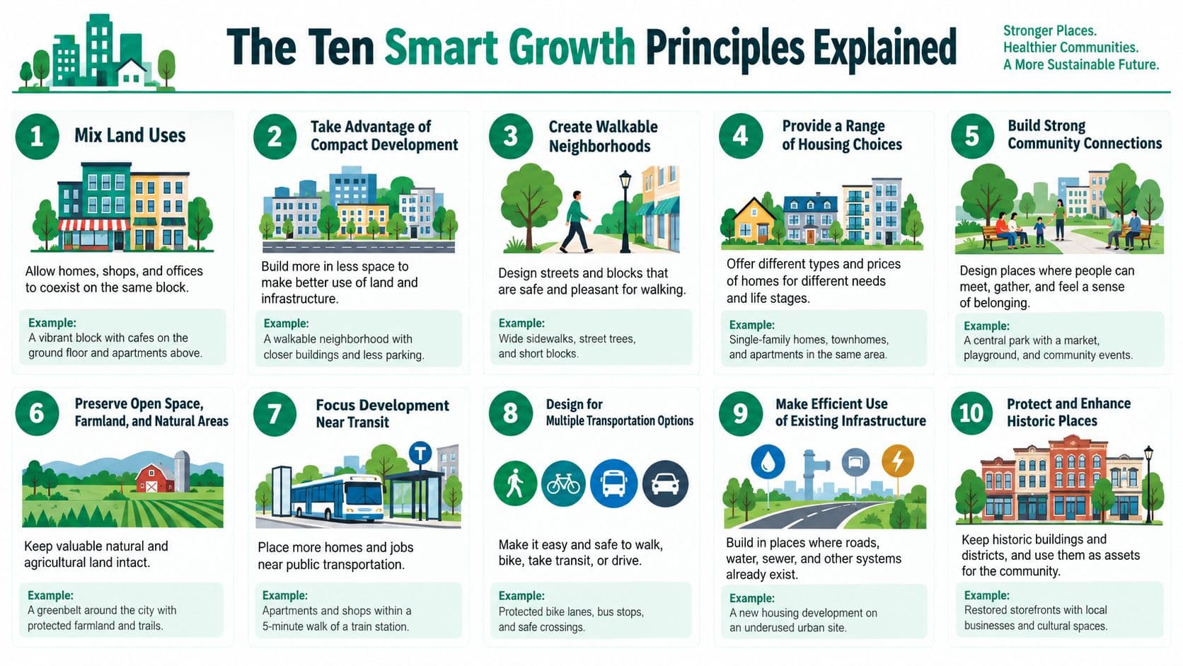
The EPA's ten principles function as ten connected design and governance choices. Each choice affects daily travel, infrastructure costs, land-use rights, and the distribution of gains from public investment. A lease grants someone permission to use a site for defined terms. A land-use right determines which activities the rules permit. Smart growth works when those two arrangements support the same neighborhood pattern.
-
Mix land uses. Allow homes, shops, offices, schools, and services to coexist. Cafés below apartments can support short errands and keep streets active after office hours. The lease and permitted use must accommodate that mix.
-
Take advantage of compact building design. Use mid-rise buildings, courtyard housing, and appropriately scaled infill instead of reserving every residential site for detached homes. More users can share existing streets and utility networks, although added capacity may still be needed.
-
Create a range of housing opportunities and choices. Permit accessory dwelling units, townhouses, apartments, and other missing-middle forms alongside larger homes. Different housing types let households remain in a community as income, age, or family needs change.
-
Create walkable neighborhoods. Place daily errands within practical walking distance, supported by connected sidewalks, crossings, shade, and safe traffic speeds. A resident should not need a car for every basic trip.
-
Foster distinctive, attractive places with a strong sense of place. Local materials, heritage buildings, public art, street trees, and recognizable civic spaces can give a district a rooted identity.
-
Preserve open space, farmland, natural beauty, and critical environmental areas. Greenbelts, wetlands, working farms, and habitat corridors should help set development boundaries before construction decisions leave them as leftover land.
-
Strengthen and direct development toward existing communities. Infill vacant parcels, reuse underperforming commercial sites, and repair established neighborhoods before opening new greenfield areas. This can improve the return on infrastructure already in place.
-
Provide a variety of transportation choices. Coordinate walking, cycling, buses, rail, shared mobility, and driving. A compact neighborhood functions in practice only when people can reach jobs and services through more than one mode.
-
Make development decisions predictable, fair, and cost effective. Clear codes, transparent fees, consistent review standards, and timely decisions reduce uncertainty. They also help finance officials match approvals with infrastructure capacity and price land-use rights more clearly.
-
Encourage community and stakeholder collaboration. Residents, landowners, businesses, developers, transport agencies, and environmental groups should participate before major choices are fixed. Early discussion can reveal displacement risks, infrastructure limits, and local assets that parcel-by-parcel review misses.
The principles also shape public finance. Mixed-use blocks can support more activity on serviced land, while walkability and transportation choice can reduce pressure for costly road expansion. Public investment may raise nearby land values, so land-value taxes or well-designed lease terms can help return part of that increase to the community. Poor pricing, however, can make development rights speculative or push costs onto residents.
For examples connecting street form, housing, and public life, explore new urbanism examples.
What the Evidence Says About Compact, Mixed-Use Neighborhoods
A finance ministry approves a denser district expecting lower infrastructure costs. Years later, residents still drive everywhere because homes, shops, streets, and transit were planned separately. The lesson is direct: density works when density, land-use mix, centered development, design quality, and accessibility reinforce one another.
Transportation research shows why. A Transportation Research Board synthesis associates a 100% increase in development density with about a 4% reduction in vehicle miles traveled, a 100% improvement in land-use diversity with about 9%, a 100% improvement in urban design with about 12%, a doubling of destination accessibility with about 22%, and improved transit accessibility with about 5% lower VMT. These figures come from the TRB smart-growth transportation synthesis. Density is one input, not a complete transport policy.
The same analysis estimates a composite smart-growth VMT elasticity of -0.16. A 10% increase in the index corresponds to about a 1.6% decrease in VMT, while dense, centered environments show roughly a 35% VMT reduction compared with sprawl-like patterns. With supportive policies, the broader evidence reports potential reductions in driving of 20% to 50%, commercial vehicle trips of 10% to 60%, and energy use and pollution emissions of 10% to 60%. These outcomes depend on the full package of land use, transport, and design choices.
Public finance follows the same pattern. A HUD-sponsored analysis of compact development and sprawl concludes that, all else equal, high-density compact development costs less to support than low-density sprawl because roads, utilities, and other services cover a smaller footprint.
| Outcome | Conventional Sprawl | Compact Mixed-Use |
|---|---|---|
| Travel | Longer trips and greater dependence on driving | Shorter trips with more viable walking, cycling, and transit |
| Infrastructure | More dispersed networks to build and maintain | Greater use of existing networks |
| Land consumption | More pressure on farmland and open space | More development directed toward serviced areas |
| Fiscal productivity | Tax base spread across a larger service area | More activity and revenue potential per acre |
| Urban experience | Separated uses and fewer nearby destinations | Daily services and housing closer together |
The evidence also clarifies the role of land pricing. If public investment raises the value of serviced land while land-use rights remain poorly priced, gains can flow to speculation instead of better neighborhoods. Reviewing the causes of urban sprawl helps identify those structural pressures.
Compact form still has limits. Density without good streets, transit, public space, or housing diversity can underperform. Attractive design without enough people and activity may not support services financially. Cities need coordinated planning and sustainable neighborhood design, with lease terms, land-use rights, and land-value policy supporting the physical pattern rather than working against it.
How Land Is Priced and Why It Changes Everything
A city may adopt sound zoning, approve compact districts, and still get weak results if it prices the underlying land relationship poorly. The confusion usually begins with three mechanisms: fixed-term land leases, land-use rights, and land-value taxation. Each assigns control, payment, and risk differently.
A fixed-term land lease gives a private party control of a site for a defined period while the government keeps ownership. The agreement may allow renewal or set a final expiry, with the price or ground rent established by its terms. Renewal offers continuity only through the existing term. At renewal, however, the gap between the old lease rate and the market rate may require a major repricing. A non-renewable lease can become harder to refinance or sell as expiry approaches, because lenders and buyers have less time to recover their investment.
The UK tax authority's guidance on land and leases identifies the relevant timing rule for capital gains tax: lease duration normally means the time remaining until the current term expires. A finite term therefore creates a measurable refinancing and resale constraint. Fixed leases can leave changing market risk outside the contract until a later review or expiry.
Land-use rights also define what a person may do with a site. Under the framework used here, they continue indefinitely and are repriced annually. That schedule lets people buy and sell the right to use land without carrying a large, hidden lease-expiry risk. The annual price reflects current land conditions, while the owner of buildings and other improvements retains the value created through construction and productive activity.
A land-value tax applies to the unimproved site value alone, excluding buildings and other improvements. The Federal Highway Administration's value-capture guidance describes a tax based solely on assessed land value, with structures excluded.
| Dimension | Fixed-Term Land Lease | Land-Use Rights | Land-Value Taxation |
|---|---|---|---|
| What is priced | Contractual access for a finite term | Indefinite access, repriced annually | Unimproved site value |
| Main risk | Repricing at renewal or expiry risk | Current annual valuation | Assessment and political transition |
| Effect on improvements | May expose buildings to lease expiry risk | Leaves improvement value separate from land | Does not tax the building itself |
| Fiscal role | Contract revenue or ground rent | Public charge for land access | Recurring public revenue |
| Smart-growth implication | Can support planning, but fixed terms postpone risk | Prices land continuously | Captures site value while avoiding a tax on construction |
These mechanisms are related, but they are not interchangeable. A lease is a contract, a land-use right is an indefinite access and control right, and a land-value tax is a public levy. For a clearer foundation in what land economics means, policymakers should identify the asset being priced, the payment schedule, and the party carrying each risk. That clarity helps land pricing support the compact, walkable, mixed-use form that smart-growth plans seek.
Implementing Smart Growth Through Land-Value Policy
A city can approve compact buildings and still produce unaffordable, poorly served neighborhoods. A workable program connects people, place, and public finance, so land-use decisions match household needs, site conditions, and the cost of maintaining services.
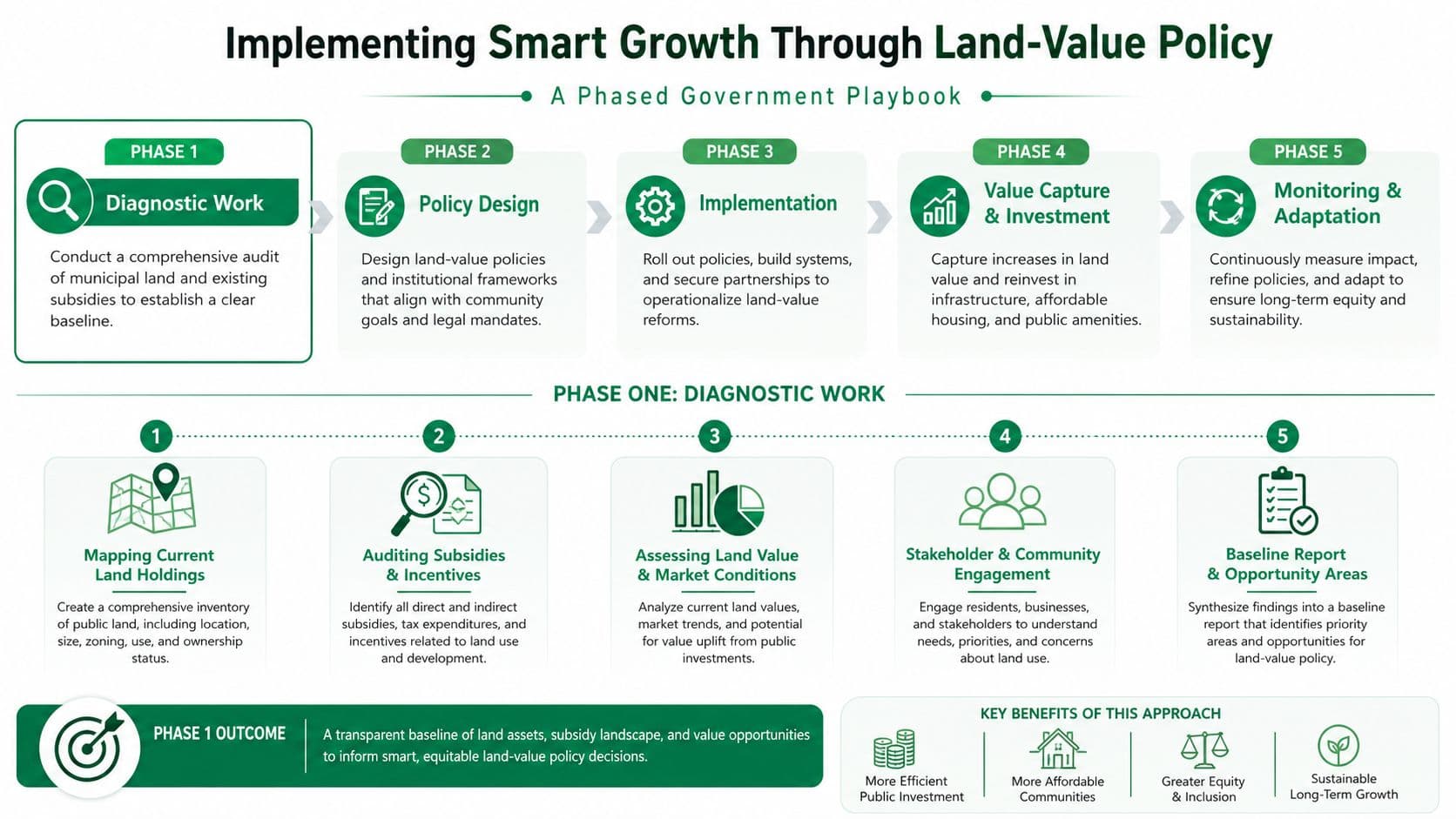
Phase one focuses on diagnosis
Begin with an integrated land and infrastructure inventory. Map public and private holdings, current assessments, vacant and underused parcels, transit access, utility capacity, housing tenure, and environmentally sensitive areas. Audit subsidies and capital programs as well, since they may make peripheral development cheaper than infill.
Finance ministries should separate land value from improvement value. The distinction clarifies site pricing and shows whether a tax system penalizes construction while allowing valuable locations to remain underused. A public cadastre and transparent valuation method give residents, investors, and officials the same starting point.
Phase two tests policy levers
Governments can pilot a split-rate property tax, assigning more weight to the land component than to the building component. Other options include ground-rent escalation clauses, transferable development rights linked to compact nodes, and community land trusts that protect long-term affordability.
Each instrument needs a defined outcome before launch. A city might monitor transit share, the balance between jobs and housing, housing affordability, vacant-site reuse, infrastructure cost per serviced household, and the share of public revenue generated from land value. Publishing the target first prevents officials from choosing a favorable measure only after results appear.
Phase three makes reform routine
Reform becomes durable through periodic revaluation, capital-gains capture where legally available, transparent assessment appeals, and public dashboards. The land-value capture guidance from Unitism offers a reference for connecting rising site values with public investment.
Implementation principle: Zoning changes require infrastructure, while pricing reform requires transition support. If either side is missing, implementation can stall through service bottlenecks, fiscal leakage, or avoidable resistance.
Land-use rights require particular care. A fixed-term lease is a contract with an end date, while an indefinite right can be repriced annually. The latter lets public authorities charge for access to valuable locations without exposing productive enterprises to a looming lease expiry. Businesses can then invest in buildings, services, and operations while policymakers continue to reflect changing land values. The trade-off is that annual valuation must be clear and credible, or uncertainty shifts from lease renewal to recurring assessment.
Case Studies From Cities and Countries That Tried It
Land policy becomes clearer when viewed through institutional choices rather than slogans. The examples below illustrate different relationships between public ownership, lease terms, taxation, zoning, and infrastructure.
Singapore is often discussed as a model of public control over development land, long-term planning, and coordinated transport investment. Its state lease approach and land-rent model show how a government can retain a strong role in allocating urban sites and directing development toward infrastructure-rich locations. The lesson isn't that every country can copy Singapore. It's that land release, transport planning, and public finance can be treated as one system instead of separate departments.
Estonia's 1993 land reform combined restitution with changes in land administration and zoning. Tallinn illustrates the complications that follow when ownership patterns, redevelopment pressure, and planning rules interact. Restoring or clarifying property rights can improve legitimacy, but fragmented ownership can also make coordinated infill difficult. Smart growth requires not only a plan for where buildings should go, but an institutional path for assembling and servicing land.
Denmark, including Copenhagen's finger-plan tradition, demonstrates how public control of development land and land-value capture can support a regional structure organized around transit corridors and protected open areas. Cycle infrastructure and compact urban form work better when public agencies coordinate the sequence of development, transport, and land release.
Pennsylvania offers a contrasting warning. Pittsburgh and Allentown have experienced the difficulty of implementing smart-growth ideas across fragmented parcels and uneven land markets. A city can possess walkable neighborhoods, redevelopment opportunities, and strong planning ambitions, yet still struggle when vacant land, weak land-value taxation, and separate ownership interests prevent public investment from producing a coherent return.
These cases shouldn't be treated as simple success or failure stories. They show that land pricing affects whether compact development is buildable, whether public agencies can recover value created by infrastructure, and whether owners face predictable or sudden changes. The transferable lesson is institutional: planners need a land strategy alongside a design strategy.
Common Pitfalls and How to Avoid Them
Compact development can fail when officials mistake permission for delivery. Upzoning may increase theoretical capacity while existing residents face displacement, infrastructure remains inadequate, or small businesses lose affordable space.
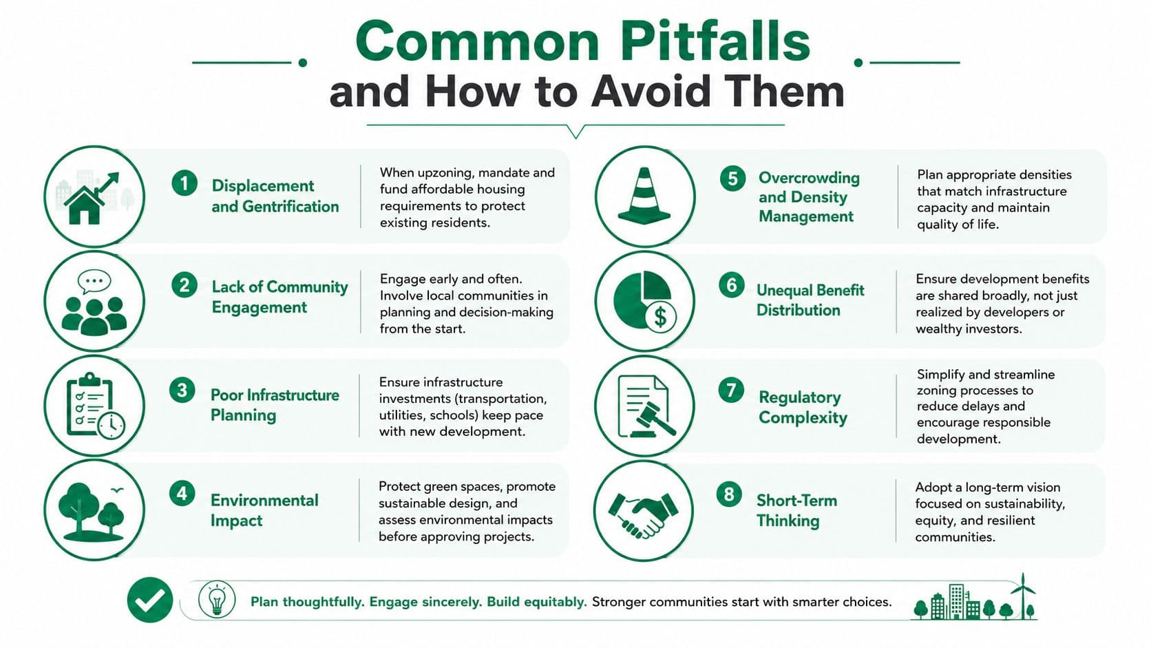
Watch for these warning signs:
- Displacement without protection: If rents rise before new homes and safeguards arrive, use anti-displacement funds, right-to-return policies, preservation programs, and community land trusts.
- Density before capacity: Tie phased upzoning to water, sewer, school, and transit improvements. Approvals should reflect what the network can support.
- Political shock: Owners may resist new land charges when officials explain neither the valuation method nor the transition. Publish assessments, offer clear appeals, and provide temporary relief where hardship is demonstrated.
- Tax volatility: A rapid shift from building-based taxation to land-value taxation can create winners and losers before the system stabilizes. Use gradual schedules and circuit-breaker rebates for eligible owner-occupiers.
- Informal settlements overlooked: Map tenure, services, and actual occupancy before applying redevelopment rules. Formalization and upgrading may be more equitable than displacement.
- Small businesses priced out: Include commercial affordability in corridor plans, not only residential housing.
- Legacy industrial sites ignored: Account for contamination, cleanup costs, and employment functions before designating land for mixed-use redevelopment.
- No exit mechanism: Add sunset clauses, review dates, and public reporting requirements so policies can be adjusted rather than defended indefinitely.
The affordability evidence also demands precision. A 2026 study found that housing-type diversity and lower dependence on single-family zoning were consistently associated with higher shares and increases in affordable housing for low-income groups, while land-use mix and accessibility showed weaker or uneven relationships, as reported in the study of smart-growth features and affordable housing. Policymakers shouldn't assume every smart-growth tool produces the same distributional result.
A 2025 assessment of Maryland's smart-growth experience reported that planners felt insufficient progress had been made and that more work was needed on equity and climate change, according to the published assessment. That finding reinforces a practical standard: measure who benefits, who pays, and who may be displaced.
A Practical Checklist for the Road Ahead
A ministry, planning department, or civic coalition can assign the following work immediately.
Diagnostic
- Map baseline land values, improvement values, vacant parcels, infrastructure capacity, transit coverage, and environmental constraints.
- Calculate the service burden of peripheral growth and compare it with infill opportunities.
- Identify households, informal residents, small businesses, and industrial employers exposed to displacement.
Policy design
- Select the applicable smart-growth principles for each district rather than applying one generic density rule.
- Compare a fixed-term lease, annual land-use right, and land-value tax against clear criteria for risk, revenue, affordability, and administrative readiness.
- Draft transition safeguards, appeals procedures, affordability protections, and public reporting requirements.
Implementation
- Phase zoning changes around transit and utility capacity.
- Pilot land-value policy in a compact district with a public dashboard.
- Establish a stakeholder council that includes residents, landowners, builders, transport agencies, and businesses.
Monitoring
- Track density, housing-type diversity, affordability, transit and walking shares, infrastructure cost recovery, land-value revenue, carbon impacts, and displacement risk.
- Revalue land transparently and publish the method.
- Review results against the original targets before expanding the program.
Use the available evidence carefully. For example, transportation outcomes should be assessed through vehicle miles traveled and mode share, while fiscal outcomes should distinguish revenue per acre from lifecycle service costs. Pricing land well is usually the slowest and highest-impact choice, so it should anchor the broader compact-development agenda rather than follow it as an afterthought.
Unitism® offers governments and civic organizations research, land valuation frameworks, policy design, distributional modeling, implementation support, and training for land-value reform. Visit Unitism® to connect smart growth principles with practical tools for pricing land, funding public services, and protecting productive investment.