Explore the fiscal and spatial impacts of low density housing. Discover land-value reform, site taxation, and implementation strategies for municipal planners.
September 12, 2026
Low Density Housing: Policy and Land-Value Reform
Explore the fiscal and spatial impacts of low density housing. Discover land-value reform, site taxation, and implementation strategies for municipal planners.
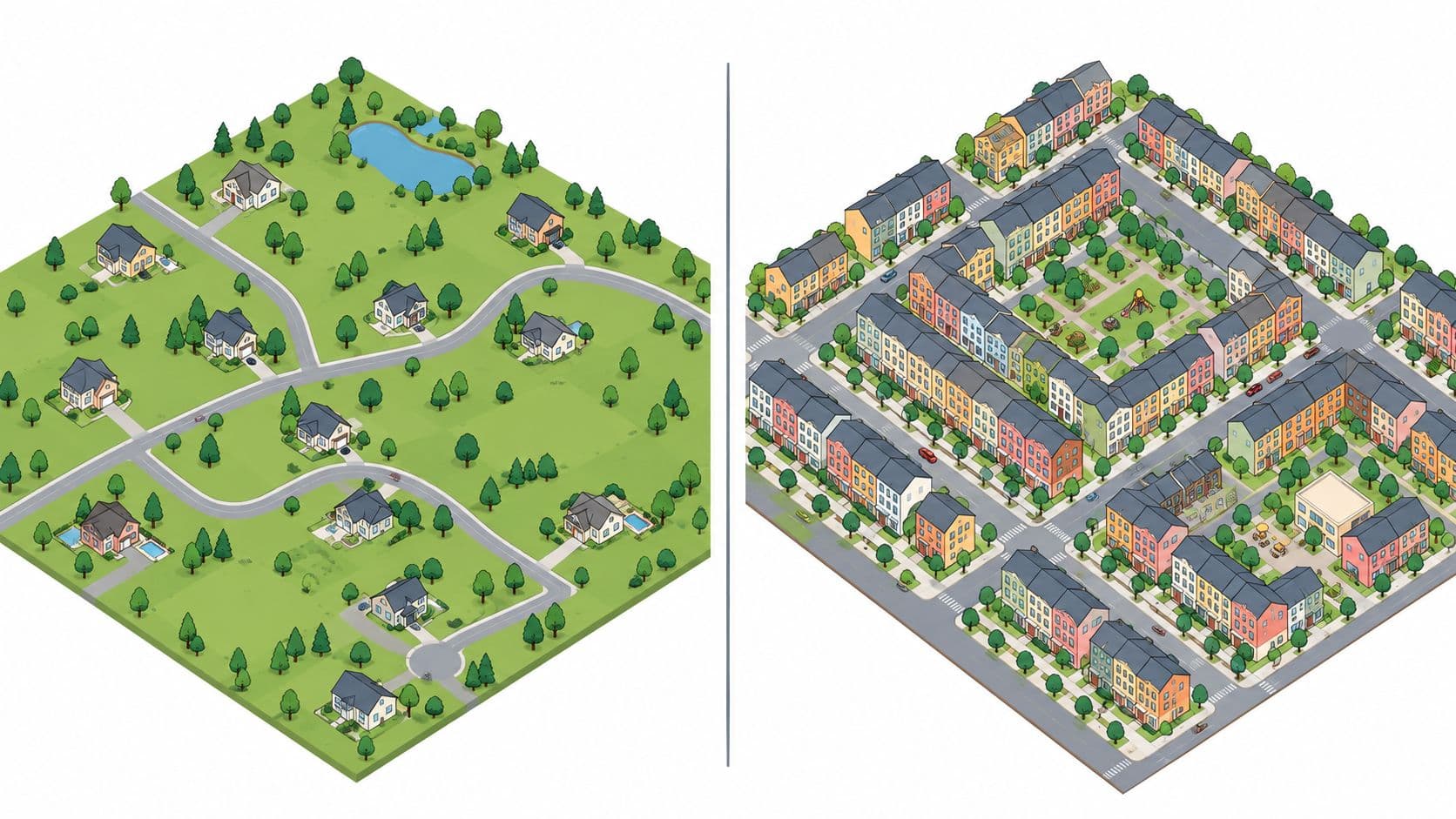
Low-density housing now occupies 58.2% of urban housing stock globally, 69.2% of total built-up area, and 63.3% of newly built urban areas created between 2010 and 2025, according to data cited by UN-Habitat's urban development research2/En/pdf). The central policy problem isn't that cities lack land. It's that governments often price land poorly, tax construction too heavily, and allow infrastructure obligations to spread across places that house relatively few people.
The answer isn't blanket high-rise redevelopment. Municipalities should identify low-rise neighborhoods near jobs and transit, permit carefully designed gentle density, and recover more of the resulting land value through transparent, recurring charges. Finance ministries should also stop confusing fixed-term land leases with genuine land-use rights. One postpones risk. The other prices land continuously.
Table of Contents
- Understanding Low Density Housing and Its Drivers
- The Hidden Costs of Urban Sprawl
- Measuring Density and Spatial Inefficiency
- Policy Responses for Municipal Planners
- Contrasting Land Leases and True Land-Use Rights
- Global Case Studies in Land Value Reform
- Implementation Steps for Finance Ministries
Understanding Low Density Housing and Its Drivers
Low-density housing is usually associated with detached homes, large lots, short blocks, and limited numbers of dwellings per hectare. UN-Habitat characterizes urban sprawl as low-density settlement that is typically car-dependent and often lacks adequate public infrastructure and services. That definition matters because density isn't only a visual feature. It determines how far roads, pipes, schools, transit routes, and emergency services must travel to reach each household.
The global pattern is structural, not accidental. The UN-Habitat evidence cited above identifies single-family housing as the main contributor to urban sprawl. It also reports that the built-up area inhabited by people increased nearly twice as fast as the world's population from 1975 to 2025, while average built-up area per person rose from 43 to 63 square metres. Cities are using more land per resident even when population growth alone doesn't require that outcome.
Why rules keep producing land-intensive growth
Zoning is the first driver. Rules that reserve extensive areas for detached homes, prohibit small apartment buildings, require large setbacks, or impose minimum parking supply make compact construction legally difficult before a developer has priced the project. The result is predictable. Land near employment becomes scarce, low-rise parcels gain speculative value, and new households are pushed farther from the urban core.
Infrastructure finance reinforces the pattern. A municipality may approve peripheral subdivisions because each project appears to deliver new tax base and construction activity. Yet the public authority remains responsible for maintaining the network after the initial development cycle. If the subdivision adds households more slowly than it adds road length and utility connections, the fiscal position weakens over time.
Speculative holding adds another distortion. Owners can wait for rezoning, infrastructure investment, or general urban growth to raise site values without building anything. A tax system that falls mainly on structures and productive activity can make holding an empty or underused site comparatively attractive. The city then experiences both housing scarcity and outward expansion.
Planning rule: Treat the value of the site separately from the value created by construction, maintenance, and human effort.
That distinction is central to the fundamentals of land economics. In a tri-factor framework, labor, capital, and nature contribute differently to production. Buildings represent capital and construction effort. The location itself, including access to public services and economic opportunity, generates a separate rental value that the private owner didn't create.
The practical implication
Municipal planners shouldn't ask only whether a home is affordable to build on a peripheral parcel. They should ask who pays to connect and maintain that parcel, who benefits from the location value created by public investment, and whether the rules suppress lower-cost forms such as duplexes, courtyard homes, small terraces, and accessory dwellings.
Low-density housing can be an appropriate choice in some places. It becomes a public-finance problem when policy makes it the default across land that could support more households, especially near employment and transit. The remedy isn't to eliminate low-rise homes. It's to remove artificial barriers to a broader housing mix and make land holding reflect its opportunity cost.
The Hidden Costs of Urban Sprawl
A detached house may look inexpensive because the lot is cheaper than a central parcel. That comparison is incomplete. The public sector still has to finance streets, drainage, water, wastewater, electricity networks, waste collection, public transport, and emergency access. When households are spread out, each dwelling carries a larger share of the network.
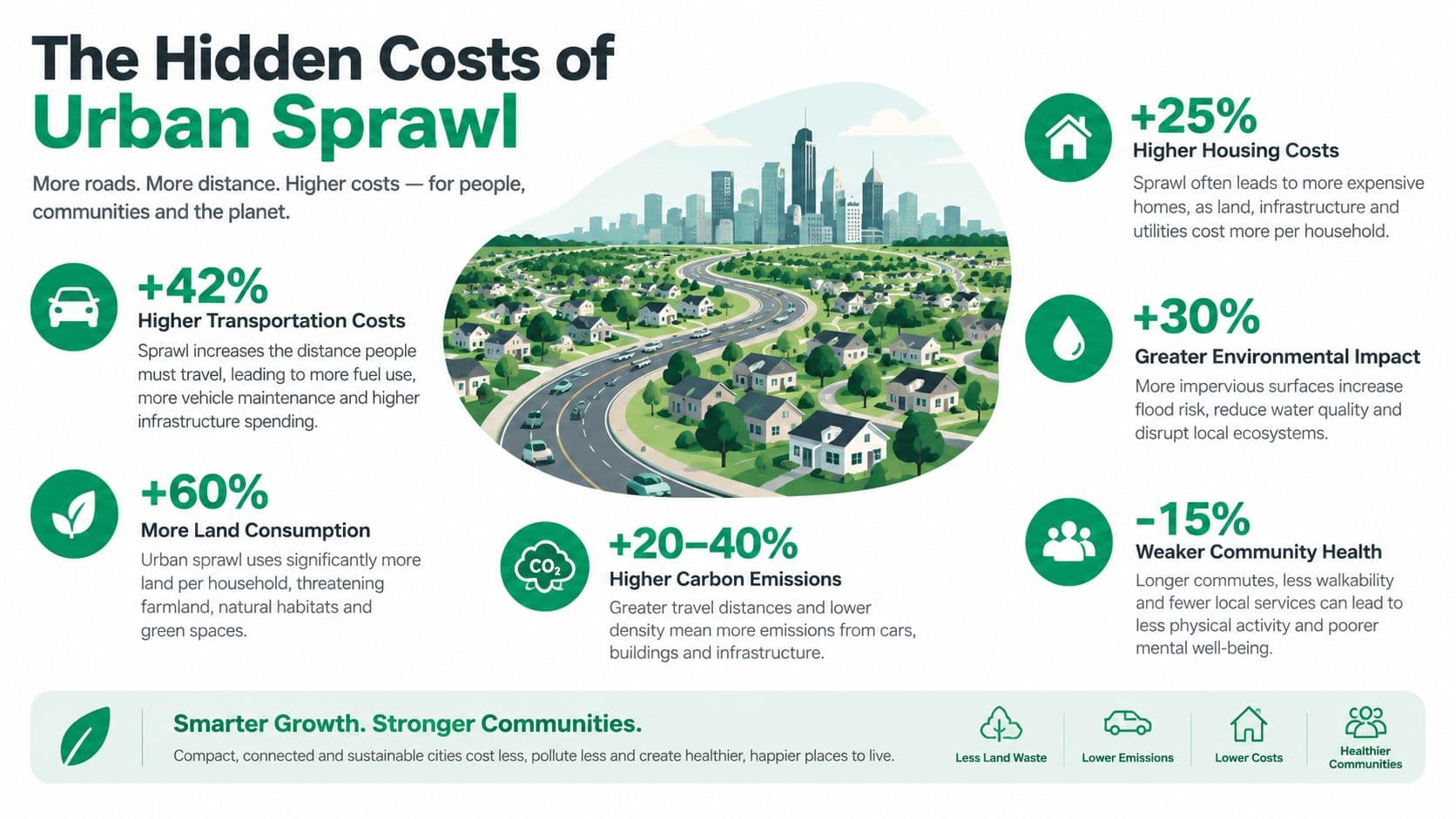
The infrastructure cost gradient is clear. A comparative study estimated costs per household at $1,053 for low-density rural development, $280 for low-density suburban development, and $124 for mid-density development, with the figures tied to different residential density assumptions in the infrastructure-cost comparison. The lesson isn't that every municipality will face exactly those amounts. It's that linear infrastructure costs rise sharply as development spreads and household concentration falls.
How the liability moves through the system
The initial developer may pay some connection costs, but municipal governments and utility ratepayers typically inherit long-term obligations. Roads deteriorate. Pipes require replacement. Low-density routes need service even when ridership is weak. A subdivision's first-year revenue can therefore conceal a future maintenance gap.
Research summarized by the U.S. Department of Agriculture on the costs of growth reports that low-density patterns can raise total public capital costs by roughly 74% compared with high-density planned development, while public capital costs for streets and utilities were about 120% higher in the sprawled case. The same source reports that infrastructure costs for sprawl are typically 5% to about 25% higher than for compact development, and annual service and infrastructure costs for a new dwelling can consume 20% to 30% of total annual costs.
These figures expose a common accounting error. Housing affordability is assessed at the property level, while infrastructure affordability is assessed at the municipal level. A household may buy a cheaper home farther out, but the city must provide a much larger service area per resident. That gap becomes a pressure on general taxation, utility charges, borrowing, or deferred maintenance.
Why sprawl increases fiscal volatility
Sprawl also magnifies boom-and-bust exposure. During expansion, governments approve roads and utilities in expectation of future development. If construction slows, the network remains while the projected tax base fails to arrive. Municipalities then face a choice between raising charges, cutting service, or postponing maintenance.
The analysis of urban sprawl's causes and consequences helps frame the issue as a land-pricing problem, not merely a transport problem. If centrally located land is held out of use while peripheral land is opened for development, the market signal encourages longer commutes and wider networks. Better fiscal policy should make infill and redevelopment financially easier than speculative vacancy.
Budget test: Before approving peripheral growth, calculate the full lifecycle cost of every road, pipe, service route, and public facility, then assign that cost to the households and land values that benefit.
Measuring Density and Spatial Inefficiency
Density policy fails when governments measure only citywide averages. A municipality can appear moderately dense overall while leaving large, valuable areas near employment and transit underused. The relevant question is not how many residents live in the metropolitan area. It's how many homes the existing serviced land can support in locations where people need access to jobs.
A practical assessment should begin with a parcel-level map that combines four layers:
- Existing built form: Record dwelling type, floor area, lot size, building coverage, and vacant or underused parcels.
- Access to opportunity: Map travel time to major employment districts, rail and bus corridors, hospitals, schools, and other public facilities.
- Network capacity: Identify streets, water, wastewater, drainage, and power infrastructure that already reaches the neighborhood.
- Development constraints: Separate genuine constraints, such as flood risk or heritage protection, from rules that merely preserve a low-density pattern.
Calculate the density gap
The density gap is the difference between existing residential capacity and a realistic policy capacity for the same location. Governments should estimate this gap at the neighborhood or corridor level, not impose one citywide target.
A useful calculation compares current homes with the homes that could fit under specific low-rise formats. Those formats might include duplexes, accessory homes, small apartment buildings, courtyard developments, lot consolidation, and modest upward extensions. The estimate should account for street width, open-space requirements, school capacity, drainage, and the cost of adapting utilities. A theoretical maximum is not a policy target. It's a distraction unless the local network and market can support it.
The geography near city centers deserves priority. A 2026 analysis of major UK cities found that low-density developments built between 1950 and 1996 represented 45.3% of all housing within 1 to 2 kilometres of city centers in Manchester, Birmingham, Glasgow, Liverpool, and Leeds. It also found post-war areas were about 40% less dense than pre-war areas in comparable locations, and estimated a density gap with French and Japanese cities of 2.3 million homes. These findings are reported in Centre for Cities' analysis of low-rise neighborhoods near city centers.
Prioritize gentle intensification
Not every low-density neighborhood should be redeveloped wholesale. A sound program ranks areas by public value and delivery feasibility.
- Start with serviced land: Prioritize places where streets and utilities already exist and where additional households can use existing transit.
- Protect residents from arbitrary displacement: Use resident engagement, transparent design rules, and relocation safeguards before approving major redevelopment.
- Permit multiple low-rise forms: Allow homeowners and small builders to choose between conversions, extensions, infill, and small-scale new construction.
- Track outcomes: Monitor permits, completed homes, rents, property taxes, utility loads, travel patterns, and resident displacement.
The measurement system should distinguish land capacity from construction capacity. A parcel may support more homes physically but remain idle because approvals are uncertain, taxes penalize improvements, or owners expect future appreciation. That is where land-value reform complements planning reform.
Policy Responses for Municipal Planners
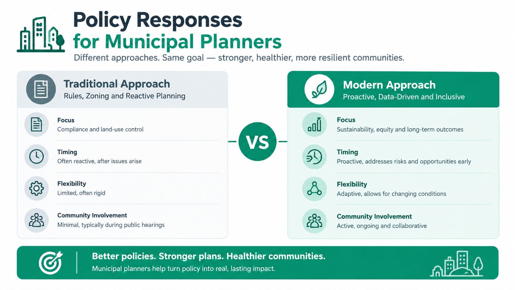
Municipalities have three broad choices. They can change zoning, subsidize infill, or change the price of holding land. The first two can increase capacity, but they won't reliably produce homes if the landowner captures the entire value of permission and waits for prices to rise.
Zoning reform remains necessary. Cities should legalize a wider range of low-rise housing, simplify approvals for compliant projects, and publish clear design standards for additions, conversions, and small lot redevelopment. Those measures reduce uncertainty and give households, nonprofit builders, and small developers a path to add homes without requiring tower construction.
Infill incentives can help where infrastructure upgrades or affordable units create a genuine viability gap. But incentives must be targeted. A blanket density bonus can inflate the value of existing sites without delivering a meaningful increase in completed housing, particularly where landowners can delay construction.
Compare the policy levers
| Policy lever | Immediate strength | Main limitation | Recommended use |
|---|---|---|---|
| Upzoning | Creates legal capacity | May capitalize into land prices | Pair with land-value capture |
| Density bonuses | Can support additional floor area or affordable units | Negotiations can be slow and opaque | Use with clear eligibility rules |
| Infill grants | Helps overcome infrastructure or financing gaps | Costs public funds | Target documented viability barriers |
| Site-value taxation | Charges the location value of land | Requires credible valuation and transition design | Use as a recurring fiscal instrument |
| Building-tax reduction | Rewards construction and improvement | Can reduce revenue if not replaced | Shift gradually toward site value |
The strongest reform combines flexible zoning with a recurring charge on site value. That approach makes underused land more expensive to hold while reducing the penalty on buildings and productive investment. It doesn't guarantee that every permitted site will be developed, but it removes a major incentive to wait for appreciation.
Make the fiscal system operational
Planners also need reliable consumption and service data. In affordable housing, submetering for affordable housing operators can help distinguish building-level utility use, support fairer allocation of costs, and improve the evidence available for operating budgets. That isn't a substitute for land reform, but it strengthens the property-level financial information needed to evaluate infill and rehabilitation.
A municipal framework based on smart growth principles should therefore connect land use, infrastructure finance, and service performance. Approve more homes where public networks can support them, charge land in proportion to location value, and publish the fiscal consequences of each growth decision.
Recommendation: Don't treat upzoning as the reform. Treat it as the legal permission that must be paired with a tax and valuation system capable of changing landowner behavior.
Contrasting Land Leases and True Land-Use Rights
Land-value taxation becomes much clearer when governments distinguish ownership, fixed leases, and true land-use rights. These instruments aren't interchangeable. Calling a fixed-term arrangement a land-use right doesn't change its economic behavior.
A land lease is a renewable or non-renewable fixed-term contract with a fixed price. A renewable lease provides some certainty during the term, but the accumulated gap between the lease rate and market value can be closed at renewal in one major repricing. A non-renewable lease becomes progressively harder to refinance and sell as its remaining term shortens. Fixed leases don't correctly price risk. They postpone it.
A true land-use right, as used here, has three defining features. It is indefinite, requires no renewal, and is repriced annually. Because the right doesn't expire and its price updates continuously, holders can buy and sell it at relatively low cost. The arrangement prices the land without placing a large maturity event in front of productive activity.
The legal distinction matters
Some governments use the phrase “land-use rights” for rights that expire after a fixed period. Under the criteria above, those are still fixed leases. They shouldn't be described as true land-use rights unless they are repriced each year, require no renewal, and don't expire.
China illustrates why legal detail matters. State-owned land-use rights can be granted for fixed terms that vary by use. Residential land is commonly 70 years, industrial land 50 years, commercial, tourism, and entertainment land 40 years, and other types 50 years, according to the Hengqin government explanation of state-owned land-use rights. A reported local regulation also states that the lease term for state-owned land-use rights should not exceed 20 years in principle in that jurisdiction. These are fixed terms, so they carry renewal or expiry risk even when the legal label differs.
China also levies land appreciation tax on gains from disposing of land-use rights or real estate. The statutory rates are progressive from 30% to 60%, as summarized by PwC's China tax reference. This demonstrates that land rights can be traded and taxed separately from buildings, but it doesn't by itself make those rights indefinite or annually repriced.
Compare the instruments directly
| Instrument | Duration and Renewal | Pricing Mechanism | Economic Impact |
|---|---|---|---|
| Renewable fixed lease | Ends at a defined term and requires renewal | Fixed during the term, then potentially repriced sharply | Creates repricing risk and encourages strategic timing |
| Non-renewable fixed lease | Ends at a defined term with no guaranteed continuation | Fixed during the term, then expires | Becomes harder to refinance and sell as expiry approaches |
| True land-use right | Indefinite and requires no renewal | Repriced annually | Keeps land value current and supports fluid transfers |
| Land-value tax on ownership | Depends on the underlying tenure | Recurring assessment of site value | Broadens revenue from location value rather than construction alone |
For a practical overview of fixed-term contracting structures, planners can consult this REIA presentation on lease options. The key policy question remains separate: does the instrument expire, or does it continue indefinitely with annual repricing?
Why annual repricing supports enterprise
Fixed leases can look stable because the payment doesn't change. That stability is incomplete. If the market value of the site rises, the fixed payment understates the location cost. If conditions deteriorate, the contract may overstate it. Either way, the adjustment arrives irregularly, often when refinancing or renewal is already difficult.
Annual repricing spreads adjustment across time. Entrepreneurs can acquire or transfer the right without buying a speculative windfall embedded in a long fixed term. Investors can assess the building and business separately from the land's current rental value. Governments can collect location value continuously rather than waiting for a sale, expiry, or renegotiation.
The same distinction applies to long-term land leases and their fiscal implications. A long term isn't the same as permanence. A contract that lasts for decades can still create a large terminal risk if it doesn't update land prices continuously.
Global Case Studies in Land Value Reform
Land-value reform is often presented as an abstract theory, but governments already administer systems that separate land from buildings, assign annual obligations, or tax gains associated with land rights. The useful lesson is institutional, not ideological. Finance ministries can create land-based revenue systems when they define the tax base, maintain records, and establish credible valuation procedures.
Taiwan provides a direct example of annual land taxation. Its land value tax system assesses annual tax on land that has been assigned a value, while agricultural land is exempt. The tax liability base date is August 31, and the recorded landowner or deed holder on that date is responsible for the full year's tax, according to the Taiwanese tax authority's land value tax material.
That structure highlights two administrative principles. First, the government needs a defined valuation record. Second, it needs a clear liability date so taxpayers and officials know who is responsible. Those principles are transferable even where the tax rate, exemptions, and assessment cycle differ.
Land rights can be taxed separately from buildings
China's land appreciation tax offers another model. The tax applies to gains from disposing of land-use rights or real estate, with progressive statutory rates from 30% to 60%, as documented in the earlier source. It doesn't create a true annual land-use right, because fixed-term rights can still expire or require renewal. It does show that legislation can identify the land component of a transaction rather than treating the entire property as one undifferentiated asset.
New Zealand offers a different legal approach to long-term leasehold interests. Its tax rules treat a lessee's interest in long-term leasehold land as an ownership interest for land-tax purposes. The lessee's interest is defined as the difference between the agreed rent and the inflation-adjusted rent that would apply without the long-term lease, as explained in the New Zealand Inland Revenue technical material.
What policymakers should take from these examples
These systems don't form one universal template. They demonstrate a menu of design choices:
- Annual assessment: Taiwan shows how a recurring land charge can attach to a recorded owner on a defined date.
- Transaction-based capture: China demonstrates how legislation can tax appreciation associated with land rights or real estate.
- Leasehold recognition: New Zealand shows how tax law can identify the economic value of a lessee's interest rather than ignoring it.
- Separation of value: All three examples support the administrative principle that land interests and building interests can be measured separately.
A finance ministry should not claim that any one model automatically solves housing affordability. The stronger conclusion is narrower and more useful. Land value is administratively visible, legally transferable, and capable of supporting recurring or transaction-based revenue. That gives governments room to reduce taxes that discourage construction while collecting more of the value created by location and public investment.
Implementation Steps for Finance Ministries
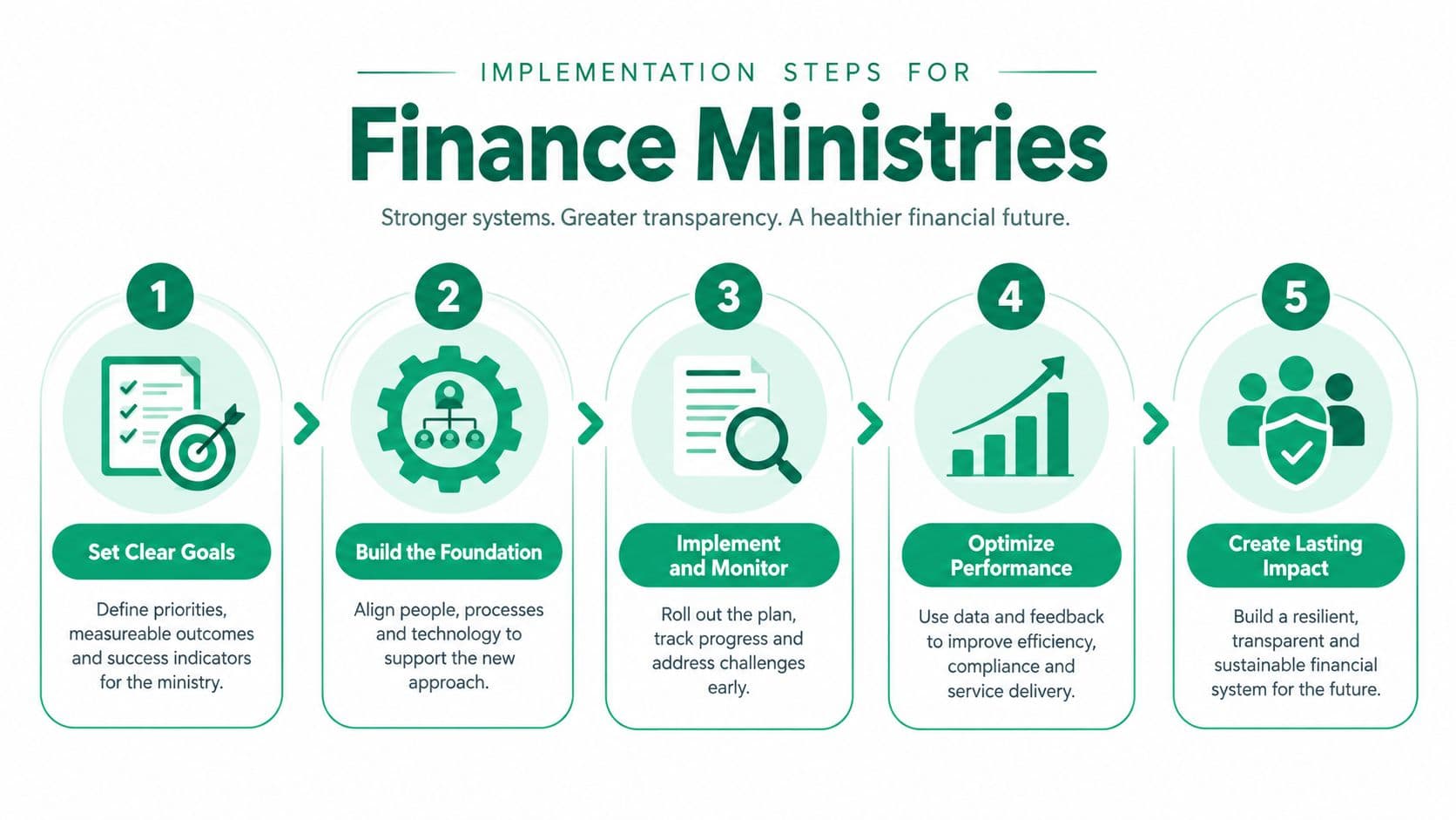
Land-value reform should begin with administrative facts, not a slogan. A ministry needs to know which parcels exist, who holds them, how they are used, what infrastructure serves them, and how location value changes across neighborhoods. Without that foundation, a new charge will appear arbitrary and invite legitimate resistance.
Start with a national or metropolitan cadastre review. Match parcel identifiers across land registries, planning systems, building permits, utility records, and tax accounts. Resolve duplicate identifiers and missing ownership records before changing liability. The objective isn't perfect data on day one. It's a transparent system that improves through routine corrections.
Build the reform in phases
-
Create the valuation base. Separate site value from building value using comparable sales, rental evidence, permitted use, accessibility, infrastructure proximity, and local market conditions. Publish the methodology in plain language.
-
Run distributional models. Show how charges change for owner-occupiers, renters, farmers, developers, nonprofit housing providers, and owners of vacant or underused land. Pair the model with scenarios for reductions in taxes on buildings, transactions, or productive activity.
-
Test the collection workflow. Define assessment notices, appeals, payment schedules, hardship procedures, enforcement rules, and data-sharing responsibilities. Pilot the process in selected municipalities before nationwide implementation.
-
Phase the transition. Introduce the land-based charge gradually while reducing taxes that penalize construction and improvement. Protect households with low current income through deferrals, credits, or payment arrangements, but don't create permanent exemptions that undermine the base.
-
Publish the results. Use interactive maps and open dashboards to show assessed site values, revenue uses, infrastructure obligations, permits, construction, and neighborhood change.
Overcome skepticism with visible delivery
The political barriers are predictable. A May 2026 U.S. survey found broad support for starter homes, smaller lots, light-touch density, and homes near jobs when proposals were framed practically. Support weakened because of supply skepticism and aversion to neighborhood change, according to the housing policy evidence summarized in the National Low Income Housing Coalition's 2026 gap report.
That skepticism can't be answered with renderings alone. Governments should publish the number and type of homes permitted, show which infrastructure already has capacity, explain who receives the land-value revenue, and commit to measurable protections for existing residents. The same source reports a shortage of 7.2 million affordable and available rental homes for extremely low-income households in the United States, with only 35 affordable and available homes for every 100 extremely low-income renter households nationwide. Gentle density won't close that gap by itself, but a credible supply program must explain how missing-middle homes, affordable rentals, and public housing fit together.
A revenue-neutral transition can make the proposal more concrete. Revenue-neutral tax reform gives officials a framework for showing how additional land-based revenue can fund reductions elsewhere rather than becoming an unexplained expansion of government. The ministry should then publish annual results and revise valuations as evidence improves.
Implementation test: If residents can't see the parcel data, the valuation method, the transition protection, and the use of revenue, they won't trust the reform.
The recommended sequence is straightforward. Measure land and infrastructure first. Legalize practical low-rise intensification near jobs and transit. Shift the tax base toward recurring site value. Distinguish true annual land-use rights from fixed leases. Protect vulnerable households during transition. Then report outcomes publicly, using evidence rather than promises.
Unitism® offers land valuation assessments, land-value capture design, fiscal impact modeling, cadastre integration, implementation support, and policy education for governments working on housing and spatial reform. Visit Unitism® to explore practical tools for separating land value from building value and designing a transition that rewards construction while funding public services.