Learn what drives the value of lot, how it's appraised, and why land-value taxes, leases, and use rights affect pricing, policy, and your bottom line.
September 27, 2026
Value of Lot Explained in Plain English
Learn what drives the value of lot, how it's appraised, and why land-value taxes, leases, and use rights affect pricing, policy, and your bottom line.

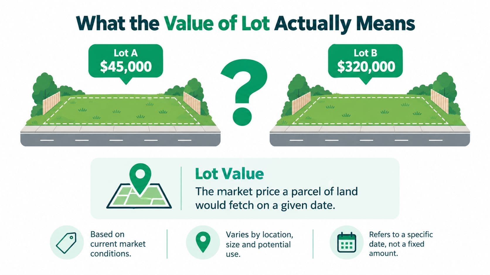
You're comparing two empty lots and the prices make no sense. Lot A sells for $45,000, while Lot B on the same street sells for $320,000. Neither parcel has a house, so why does one command more than seven times the price of the other?
The answer is the value of the lot, which is the market value of the land itself, separate from any building or other improvement. Location, zoning, access, infrastructure, scarcity, and development potential can make apparently similar parcels economically very different.
Table of Contents
- What the Value of Lot Actually Means
- The Six Drivers That Shape a Lot's Price
- How Appraisers Estimate the Value of Lot
- Land-Value Capture and the Land-Value Tax
- Land Leases Versus Land-Use Rights Versus True Annual Repricing
- Real-World Precedents in Land-Value Reform
- Estimating the Value of Lot in Practice
- Key Takeaways on Lot Value
What the Value of Lot Actually Means
The value of a lot is the price a parcel of land would fetch on a particular date under ordinary market conditions. It answers a simple question: What would a willing buyer pay for this land, and what would a willing seller accept, assuming neither is under unusual pressure?
That definition separates the land from improvements. A house, garage, driveway, retaining wall, or utility connection may add value, but those items are not the lot itself. Appraisers often estimate the land component separately because buildings wear out, can be replaced, and may not represent the most productive use of the site.
Land has a special economic character. It's finite, immobile, and not produced by human labor. Nobody manufactures another central-city location. Owners can improve a parcel, but they can't move it closer to jobs, a rail station, a school, or a waterfront. Those location advantages often become part of the price buyers pay for the site.
Practical rule: A high sale price doesn't automatically mean the building is valuable. It may mean the underlying site has strong location value.
The two lots in the opening example might have different zoning, frontage, utility access, flood exposure, or permitted building size. Lot B might support apartments or shops, while Lot A might allow only one detached home. The correct comparison therefore depends on each parcel's highest and best use, meaning the use that is legally allowed, physically possible, financially feasible, and maximally productive. A plain-language guide to that idea appears in this explanation of highest and best use.
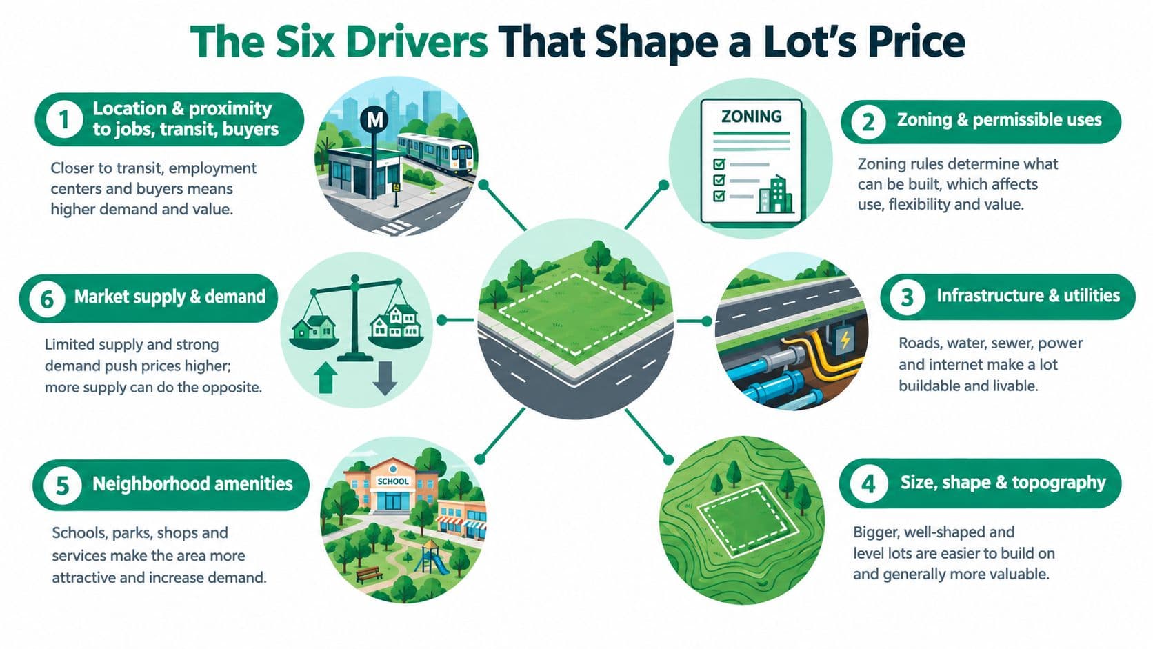
Six forces usually explain most of the difference between parcels:
- Location, including access to employment, transport, and buyers.
- Zoning, which determines what an owner may build.
- Existing improvements, such as reusable foundations or demolition obligations.
- Infrastructure, including roads, sewers, power, and broadband.
- Amenities, such as parks, schools, views, and nearby services.
- Highest and best use, which converts all those factors into a realistic development opportunity.
The rest of the valuation process is an exercise in measuring those advantages, separating land from structures, and deciding how public policy should charge for location value.
The Six Drivers That Shape a Lot's Price
A lot's price isn't a mysterious number attached to a map. It's the market's combined estimate of what the site can provide and what buyers can legally do with it.
Location starts the calculation
A corner parcel near a new subway stop may attract commuters, retailers, apartment developers, and investors. A similar-sized parcel farther from transport may attract only a narrower group of buyers. Proximity to jobs, transit, customers, and construction services affects both present demand and expected future income.
Location doesn't mean “famous neighborhood” alone. It includes travel time, street visibility, access to arterial roads, exposure to hazards, and the ease with which residents or customers can reach the site.
Zoning sets the opportunity
Zoning can change value more sharply than physical appearance. An R-1 parcel restricted to detached housing may become far more valuable if the authority permits mid-rise mixed-use development. The land hasn't moved, but the legal opportunity attached to it has changed.
That opportunity also carries limits. Height caps, setbacks, parking rules, lot-coverage restrictions, environmental overlays, and approval risk can reduce the amount a developer will pay. Buyers value permission that is clear and usable, not merely a speculative possibility. For a broader discussion of the forces that drive property value, see this guide to the best value driver.
Improvements can help or hurt
An old foundation may reduce construction costs if it can be reused. A dilapidated structure may do the opposite if the buyer must pay for demolition, asbestos removal, or environmental cleanup. The relevant question isn't whether something stands on the lot. It's whether that item contributes more value than it consumes.
Infrastructure removes friction
A parcel with a sewer hookup, paved alley, reliable electricity, and fiber connection is easier to develop than a remote site requiring costly extensions. Infrastructure can also improve the timing of a project, because a buyer may avoid lengthy negotiations or uncertain connection work.
Amenities attract competing buyers
Parks, schools, waterfront views, shops, and public services can increase demand. Some amenities create direct commercial value, while others make housing more desirable. Their effect depends on the permitted use and on whether buyers can access them.
Highest and best use ties the pieces together
A site's highest and best use must pass four tests: it must be legally permissible, physically possible, financially feasible, and maximally productive. A tall apartment building might be physically possible but prohibited by zoning. A retail project might be legal but financially unworkable because the customer base is too small.
Return to Lot A and Lot B. Ask the same questions of both parcels:
- Is one closer to jobs, transit, or customers?
- Does one permit more valuable uses?
- Does one have better utilities or less difficult terrain?
- Does one offer stronger views, services, or neighborhood amenities?
- Would a developer earn more from one site after paying all project costs?
The price gap becomes easier to understand once you stop comparing empty ground and start comparing usable opportunities.
How Appraisers Estimate the Value of Lot
Appraisers don't rely on one universal formula. They choose a method that fits the parcel, the market, and the available evidence.
Sales comparison
The sales-comparison method starts with recent sales of similar vacant parcels. The appraiser adjusts those sales for size, frontage, zoning, slope, access, utilities, and timing. It works best where vacant land changes hands often enough to provide meaningful comparables, such as an active suburban residential market.
Income capitalization
Income capitalization treats the site as an income-producing asset. The appraiser estimates the net operating income attributable to the land and converts that income into a value using a capitalization rate. This approach suits commercial sites, parking land, ground-rent investments, and other parcels with observable income.
Residual valuation
The residual method works backward from a completed project. The appraiser estimates the finished value, then subtracts construction costs, professional fees, financing, marketing, and the developer's required profit. What remains is the amount the project can support for land.
This method is especially useful for redevelopment sites where vacant-lot sales are scarce. It's also sensitive to assumptions, so a small change in the project's sale revenue or construction budget can materially alter the indicated land value.
Hedonic pricing
Hedonic models use statistical analysis to separate the land value embedded in improved-property sales. They compare many transactions and estimate how features such as location, floor area, age, access, and zoning affect price. The method helps when most available sales include buildings rather than vacant land.
Mass appraisal
Mass appraisal values many parcels across a jurisdiction at once. Assessors combine cadastral maps, transaction data, zoning, geography, and regression models to apply consistent relationships across neighborhoods. The mass appraisal methods guide provides further context on that process.
| Method | Data Required | Best For |
|---|---|---|
| Sales comparison | Recent vacant-lot sales and parcel adjustments | Active residential land markets |
| Income capitalization | Net land income and a capitalization rate | Income-producing commercial sites |
| Residual | Finished value, project costs, financing, and profit assumptions | Development and redevelopment land |
| Hedonic pricing | Large improved-property transaction datasets | Separating land from buildings |
| Mass appraisal | Parcel maps, sales, zoning, and spatial variables | Jurisdiction-wide assessment |
The method should match the question. A buyer studying a suburban homesite may begin with sales comparison. A city assessing thousands of parcels may need mass appraisal. A developer considering a teardown will usually learn more from a residual calculation than from a distant vacant-lot sale.
Land-Value Capture and the Land-Value Tax
A new rail station, zoning change, public road, or utility extension can increase the value of nearby sites. The owner may not have created that gain, but the public investment or legal decision helped create it. Land-value capture refers to tools that return part of that location-created value to the community.
Governments can use impact fees, betterment charges, special assessments, development contributions, or sale-leaseback arrangements. A land-value tax, or LVT, takes a broader approach by taxing the unimproved site rather than the building erected on it.
That distinction changes incentives. If a city taxes buildings heavily, an owner may postpone construction, renovation, or expansion. If the charge falls mainly on land value, the owner still pays for holding a valuable site, but adding a productive building doesn't create the same tax penalty.
Three behavioral effects follow:
- Underused sites become harder to hold idle. An owner of a vacant urban parcel faces a continuing cost and may sell, develop, or assemble the site with neighbors.
- Land banking becomes less attractive. Speculators can't rely as easily on waiting for an unearned location gain while contributing little to the community.
- Public revenue follows the site base. Land prices can move with economic conditions, but land remains tied to a physical tax base that cannot relocate offshore.
The third point needs care. Land-value revenue isn't immune to downturns. Agricultural land values, for example, fell 37% over three years in the early 1930s, while another downturn reduced average U.S. agricultural land and building values from $801 per acre in 1984 to $599 in 1987, a 25% decline. Those cycles show why governments need realistic valuations, reserves, and phase-in rules. The historical series is documented by the USDA land-value data.
Pennsylvania's split-rate approach illustrates a middle position. A municipality can tax land at a higher rate than buildings, rather than moving immediately to a pure LVT. Anyone comparing property-related charges should separate land taxation from transfer charges, and a tax calculator for agents can help distinguish those obligations.
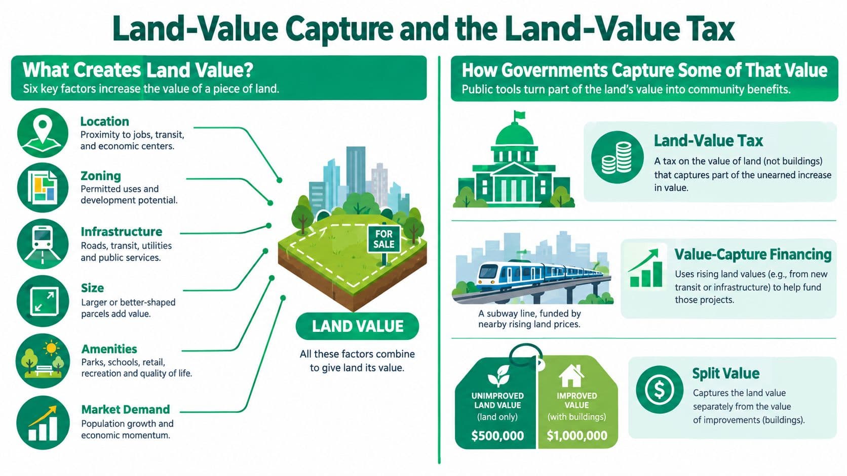
The central policy choice is simple: should government charge more for building and productive activity, or for exclusive control of valuable locations? The land-value capture framework treats the site premium as the appropriate base for recovering part of the value created by the wider community.
Land Leases Versus Land-Use Rights Versus True Annual Repricing
These arrangements are often confused because they all give someone permission to occupy or use land. Their financial consequences differ sharply.
A fixed-term land lease sets a rent or price for a defined period. It may be renewable or non-renewable, and the contract might include scheduled increases, but the price remains governed by the agreement until the next contractual reset. A renewable lease offers certainty only until its term ends. At renewal, the accumulated gap between the contract rate and the market can close in one major repricing. A non-renewable lease becomes progressively harder to refinance and sell as the expiration date approaches.
Fixed leases don't remove risk. They postpone it.
A Chinese-style land-use right is also time-limited, although it can provide a broad bundle of use, transfer, mortgage, and inheritance rights during the grant period. China distinguishes terms by use category: 70 years for residential land, 50 years for industrial land, 50 years for education, science, culture, health, and sports land, 40 years for commerce, tourism, and recreation land, and 50 years for general or other uses. These terms are described in the Chinese land-use-right framework.
That makes a Chinese-style grant different from an indefinite right. Renewal can require a new premium and a new grant contract. If renewal isn't applied for or approved, the rights and improvements can revert to the state without compensation, as explained in this overview of real-estate practice in China. Chinese land-use rights are also distinct from ordinary leases, whose contractual term is limited to 20 years under the cited legal discussion of PRC land arrangements in this FAO legal resource.
A true annually repriced land-use right meets three conditions:
- It's repriced every year against the unimproved site value.
- It requires no renewal.
- It doesn't expire while the holder meets the legal obligations.
That arrangement behaves differently from a fixed lease or fixed-term grant. The holder can transfer a right without waiting for a distant renewal date, while the community receives the current rental value as it arises. A legislative explanation of this contrast describes annual repricing as having no renewal requirement and no expiration when properly designed, unlike a fixed-price lease. See the annual land-value repricing explanation.
| Feature | Fixed-Term Land Lease | Chinese-Style Land-Use Right | Indefinitely Repriced (LVT) |
|---|---|---|---|
| Term | Fixed period, renewable or non-renewable | Fixed grant period by use category | Indefinite, with annual repricing |
| Transfer rights | Governed by the lease | Broad rights may include transfer, mortgage, and inheritance during the term | Transferable without renewal risk, subject to legal rules |
| Residual value at expiry | Depends on renewal and contract terms | Reversion risk can affect value and finance | No expiration event under proper design |
| Who captures appreciation | Owner, lessor, or both, depending on contract | Holder during the term, with the state retaining the underlying land interest | Community captures annual site rent, holder retains use value and improvements |
Calling a fixed-term grant a “land-use right” doesn't make it an indefinitely repriced right. The label is accurate only when the arrangement is annual, non-expiring, and not dependent on renewal. Readers interested in the problems created by long fixed terms can explore this discussion of 99-year land leases.
Real-World Precedents in Land-Value Reform
Land-value policy appears in several forms because governments combine revenue needs, administrative capacity, and political constraints differently.
Denmark moved much of its property tax burden toward land values between 1920 and 1930 and has retained a roughly 60/40 land-to-building split. Estonia adopted a land-value-only tax in 1993, separating the taxable site from structures and making vacant central land part of the tax base.
Singapore uses state ownership and 99-year leases to capture part of land appreciation. Lease-top-up premiums can also apply when rezoning increases development potential. This model resembles a public landlord collecting value through grants and renewals, rather than an annual tax on every parcel's independently assessed site rent.
Pennsylvania allows cities to adopt split-rate taxation. Pittsburgh's 2024 rates, about 6.91% on land and 0.51% on buildings, illustrate a strong tilt toward taxing the site rather than improvements. The policy doesn't eliminate tax administration, but it changes the relative cost of holding land idle and adding structures.
Alaska offers a different example. Its 1979 windfall oil-tax act applied land-value-capture logic to natural resources rather than ordinary urban lots. The government used a threshold-based approach to claim part of exceptional resource value while leaving the underlying productive activity in private hands.
| Jurisdiction | Year | Mechanism | Observed Result |
|---|---|---|---|
| Denmark | 1920 to 1930 | Greater reliance on land-value taxation | Long-running land and building tax split |
| Estonia | 1993 | Land-value-only tax | Buildings separated from the taxable base |
| Singapore | Not specified here | State leases and lease-top-up premiums | Public capture of land appreciation |
| Pennsylvania | 2024 rates cited above | Local split-rate taxation | Higher relative charge on land than buildings |
| Alaska | 1979 | Windfall resource-value taxation | Land-value capture applied to oil resources |
These examples aren't interchangeable. Denmark and Estonia use recurring tax mechanisms, Singapore uses state land grants and lease administration, and Pennsylvania lets municipalities adjust the balance between land and buildings. The common principle is that public policy can target the value of nature and location without treating buildings, wages, and enterprise as the same economic base.
Estimating the Value of Lot in Practice
A practical estimate starts with evidence, not a calculator. A property owner, student, or policymaker can build a defensible first pass by following a short sequence.
Start with comparable land
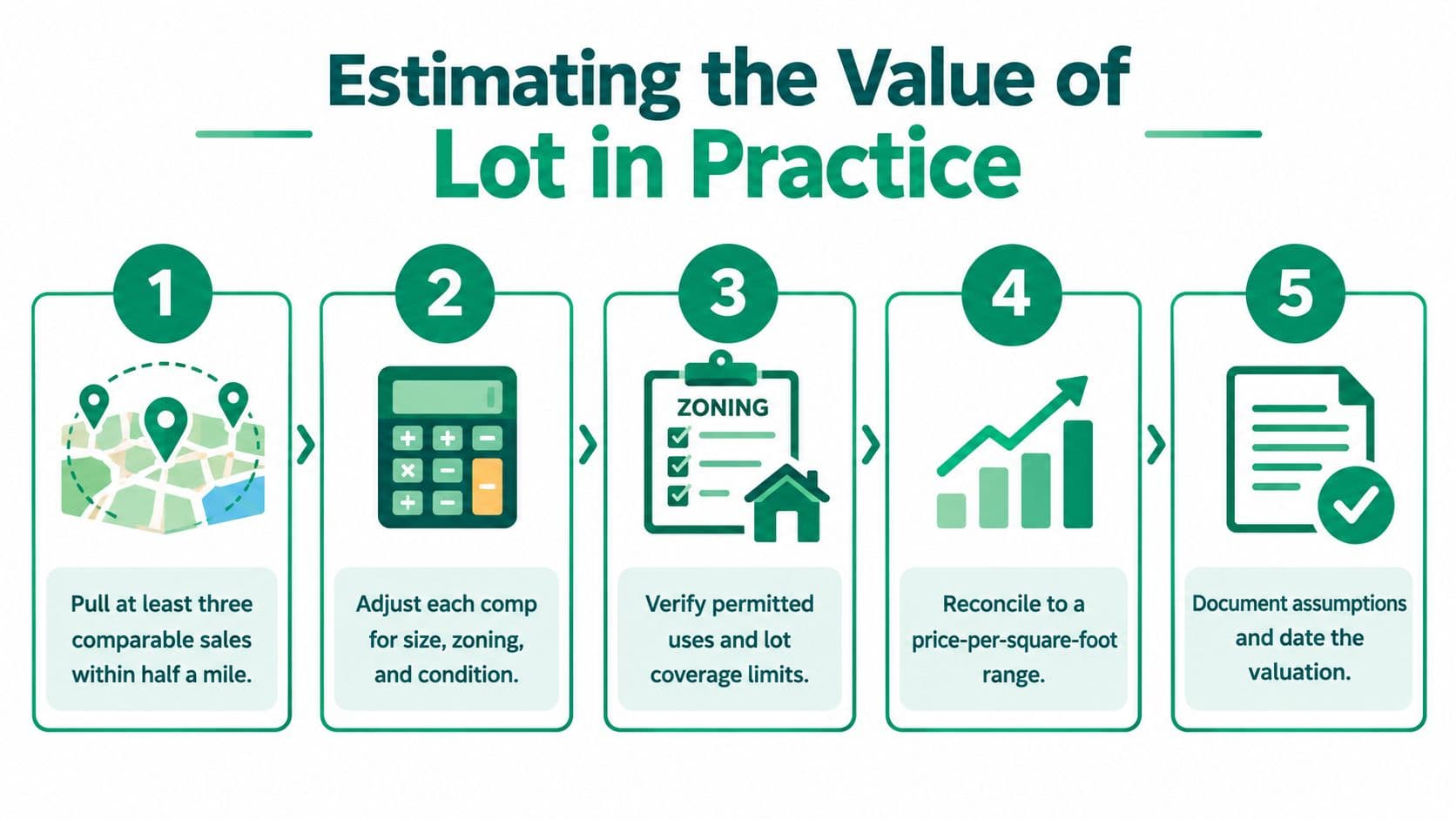
Pull at least three comparable sales within half a mile and in the same zoning class. Then adjust for parcel size, frontage, slope, access, utilities, demolition needs, and any income-producing potential. The goal isn't to find a perfect twin. It's to explain why each comparable is more or less useful than the subject lot.
Test the result against another method
Use sales comparison to establish a range, then check it with a quick income-capitalization or residual calculation. An income check is useful for commercial land. A residual check is useful when the site's main attraction is redevelopment potential.
Verify the legal opportunity
Read the current zoning map, development code, lot-coverage rules, height limits, parking requirements, and infrastructure schedules. A sale that looks comparable may be misleading if the other parcel has a different permitted use or a more advanced approval status.
For public agencies, the same logic operates at scale. Combine parcel-level sales, cadastral maps, zoning layers, infrastructure data, demographic information, and planning records in a transparent dataset. Assessors can then use unit-value maps, hedonic models, or mass-appraisal techniques while publishing assumptions that residents can review.
Stress-test the result under two scenarios: the current highest and best use, and a plausible rezoning scenario. Don't assign a precise option-value percentage without market evidence. Instead, show how the price changes if the proposed permission is delayed, denied, or approved.
Finish with a one-page memo containing the valuation date, comparable sales, adjustments, assumptions, confidence level, and tenure context. A fixed lease, Chinese-style time-limited use right, and indefinitely repriced right can produce different marketability and financing outcomes even when the physical parcel is identical.
Key Takeaways on Lot Value
Three ideas make the value of a lot easier to understand.
First, location is usually the scarce asset. A building can depreciate, be renovated, or be replaced. A site's relationship to jobs, transport, schools, infrastructure, and amenities is harder to reproduce. Urban land research estimates that private land in the contiguous United States was worth about $24 trillion in 2015, or roughly $19,050 per acre, and that residential land categories represented nearly 73% of total land value in 2006, according to the American Enterprise Institute land-price indicators. The figures show why the land beneath a property can dominate the wealth associated with it.
Second, the valuation method shapes the answer. Sales comparison fits active vacant-land markets. Income capitalization fits revenue-producing sites. Residual analysis captures development potential. Hedonic models separate land from buildings in improved sales, while mass appraisal creates consistent assessments across many parcels.
Third, the charging system shapes behavior. A fixed lease postpones repricing risk. A Chinese-style land-use right grants substantial rights for a defined term but remains exposed to expiration and renewal conditions. An indefinitely repriced land-use right has no renewal requirement or expiration and updates the site charge annually. A land-value tax similarly shifts public revenue toward the location premium and away from construction and productive improvements.
Land value is therefore more than a sale price. It's a measure of access, legal opportunity, public investment, and scarcity, and it becomes a policy choice when governments decide who should receive or recover the resulting rental value.
Unitism® helps governments, cities, and organizations estimate site rental values, map parcel-level land drivers, and design land-value capture policies that distinguish land from labor and capital. Visit Unitism® to explore practical valuation, modeling, education, and implementation support for land-based reform.