A practical guide to climate resilience planning for governments — from risk assessment and land valuation to financing, implementation and monitoring.
September 21, 2026
Climate Resilience Planning How to Build Funded Plans
A practical guide to climate resilience planning for governments — from risk assessment and land valuation to financing, implementation and monitoring.

Only 3 of 46 outcomes in the UK received a good policy-and-planning score, while 27 outcomes, or 60%, showed limited or insufficient progress according to the European Environment Agency summary of UK Climate Change Committee findings. That's the right place to start, because climate resilience planning doesn't usually fail at the strategy stage. It fails at the point where a ministry, city, utility, or transport authority has to assign ownership, secure revenue, sequence projects, and keep decisions current as risks change.
A plan is easy to praise when it's broad. It gets harder when it has to name which assets move first, which neighborhoods absorb the next wave of investment, which agency maintains the intervention, and which fiscal instrument pays for it. That's where resilience stops being a policy statement and becomes a delivery problem.
The teams that make progress treat climate resilience planning as a chain. Risk assessment informs project design. Project design informs valuation. Valuation informs fiscal choices. Fiscal choices determine whether delivery can continue after the launch event. Monitoring then tells you whether the system is reducing exposure, or just generating paperwork.
Table of Contents
- Why Most Climate Resilience Plans Stall Before Implementation
- Mapping Risk and Vulnerability With a Repeatable Assessment Workflow
- Valuing Land and Nature to Price Exposure and Opportunity
- Choosing Land Value Capture Instruments Without Postponing Risk
- From Modeling to Delivery Through Fiscal Design Financing and Engagement
- Keeping Resilience on Track With Monitoring Evaluation and Updates
Why Most Climate Resilience Plans Stall Before Implementation
The implementation gap is the central problem. Urban adaptation planning is now common enough to look mainstream, but follow-through is much thinner. The IPCC notes that many more cities have developed adaptation plans than in the previous assessment cycle, yet only a limited number of those plans have been implemented. In the European Union, a review of 885 cities found that about 26% had an adaptation plan, 16% had a joint adaptation-and-mitigation plan, and roughly 33% had no stand-alone local climate plan at all. The same review found that around 80% of cities with more than 500,000 inhabitants had either a mitigation or adaptation plan, which shows how strongly resilience capacity tracks city scale and institutional depth, as summarized in the IPCC AR6 urban adaptation chapter.
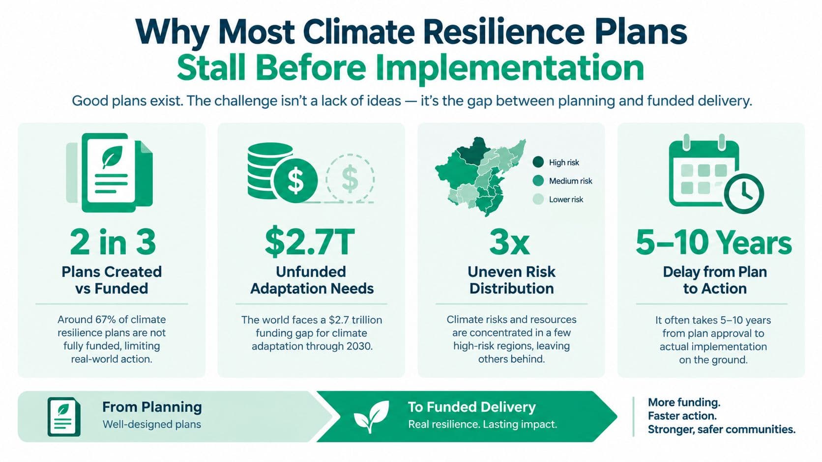
Plans fail when ownership is vague
Most stalled plans share the same pattern. Hazard maps exist. Strategic language is polished. But nobody owns the drainage retrofit program, the heat-health protocol, the culvert maintenance budget, or the relocation trigger for repeatedly damaged assets.
That weakness shows up in national adaptation systems too. UNEP reports that 87% of countries have at least one national adaptation planning instrument, but only 51% have a second instrument and 20% a third. It also reports that 36 countries have plans that are outdated or haven't been updated for a decade in its Adaptation Gap Report 2024 interactive summary. The issue isn't only whether a plan exists. It's whether the plan keeps pace with real assets, budgets, and operating conditions.
Practical rule: If a resilience action has no named owner, no operating budget, and no trigger for update, it isn't an implementation measure yet.
Funded delivery needs a different design discipline
A funded plan has to do three things that shelf plans usually avoid:
- Name the risk owner: Someone has to be accountable for each intervention across design, procurement, maintenance, and review.
- Link action to revenue: Capital works, nature-based measures, and service changes all need an identified funding path, not a generic financing aspiration.
- Build updates into the plan: Climate resilience planning decays fast if the risk assumptions, asset conditions, and fiscal base aren't revisited on a routine cycle.
Digital systems matter here because they connect data, asset management, and service decisions. For a useful example of that wider operating logic, see how Kagool links sustainability and digitalization. The point isn't software for its own sake. It's that resilience work breaks down when climate data, capital planning, procurement, and maintenance records live in separate silos.
A practical rollout also benefits from staged execution rather than a single grand launch. That's why a phased implementation approach is often more credible than a plan that promises simultaneous transformation across every sector.
Mapping Risk and Vulnerability With a Repeatable Assessment Workflow
Most resilience planning starts too wide. Teams compile every available hazard layer, generate a thick risk register, and then struggle to decide what changes in the next budget cycle. A better method is sequential. Define the vulnerability context first. Then test whether adaptation is explicitly linked to project activity. Then integrate climate and disaster projections into siting, design, and operations. That sequence reflects the logic in the World Bank Resilience Rating System methodology.
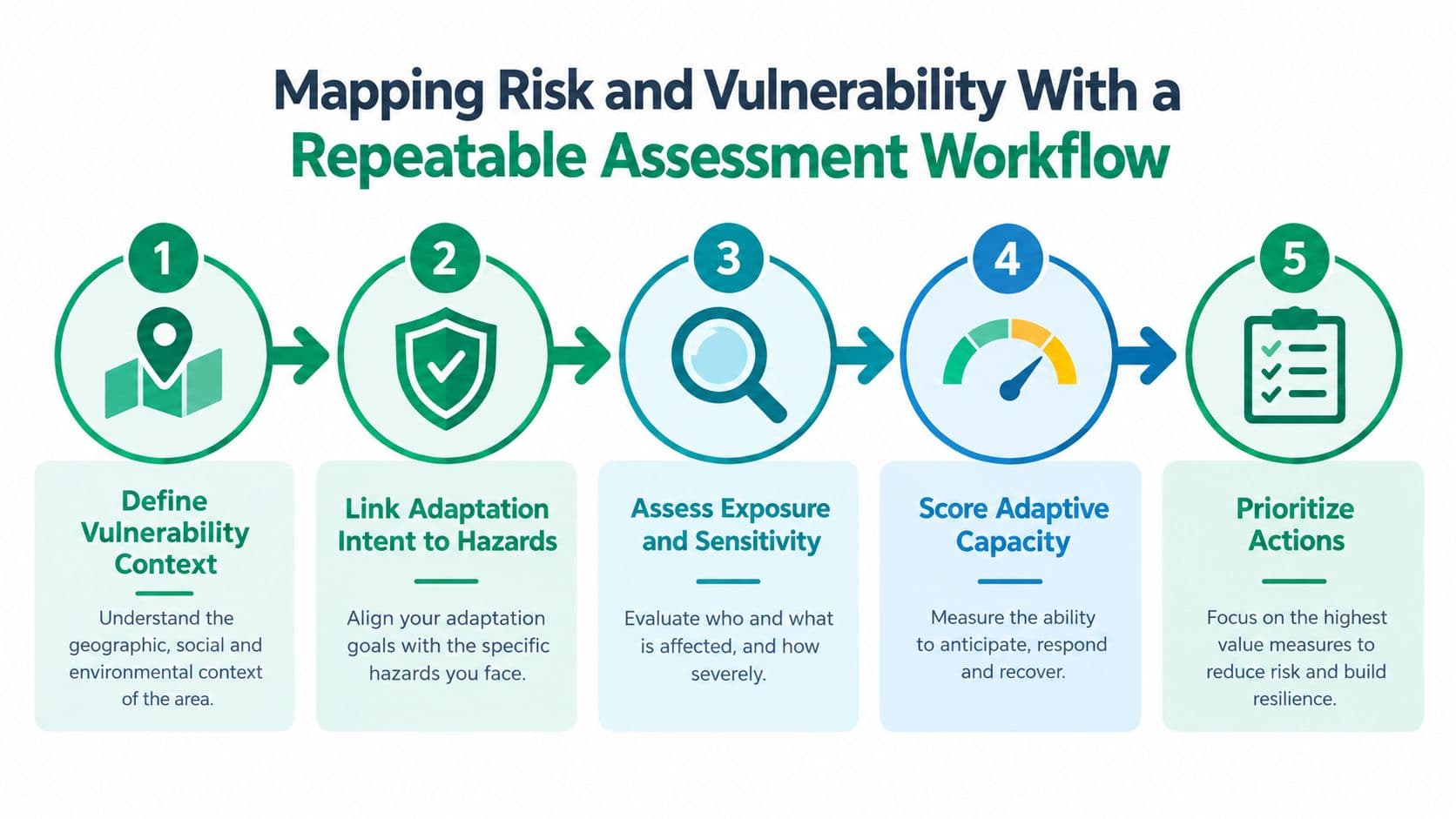
Start with a vulnerability context people can act on
The first pass shouldn't ask, “What are all our climate risks?” It should ask, “Which systems fail, where, for whom, and under what conditions?” That changes the conversation immediately.
A workable vulnerability context usually includes:
- Critical functions: Water supply, mobility, emergency response, public health, housing access, and grid reliability.
- Exposure geography: Flood-prone corridors, heat islands, unstable slopes, coastal edges, and service bottlenecks.
- Affected groups: Renters, informal workers, older residents, low-income households, people with chronic illness, and neighborhoods with weak service redundancy.
If you're building local screening tools, geospatial feeds can help ground the discussion in parcel and neighborhood conditions. A practical reference point is this PropTech climate data API, which shows how climate-layered property context can be integrated into operational assessment workflows.
Make adaptation explicit in each project
Many public investment programs drift. They label an asset “resilient” because it has a green component, or because the project notes mention climate. That isn't enough.
Use a simple test set:
- Hazard linkage: Does the project name the hazard it is designed to address?
- Functional outcome: Does it state what service failure it prevents or reduces?
- Design consequence: Does the climate analysis change location, standards, materials, redundancy, or maintenance requirements?
A project isn't resilient because the concept note says so. It's resilient when the climate risk changes a real design choice.
Score adaptive capacity and prioritize a pipeline
At this stage, the task isn't just ranking risk. It's building a bankable project pipeline. The World Bank's adaptation guidance emphasizes whole-of-government planning, mandatory climate risk screening, and national adaptation investment plans as essential steps for converting resilience goals into financeable programs in its Climate Change Action Plan on Adaptation and Resilience.
That means scoring should reflect delivery, not just danger:
- Near-term readiness: Can the agency procure and supervise the work?
- Dependency profile: Does the project require upstream land, utility, or legal changes first?
- Fiscal fit: Can it be matched to a stable funding stream?
- Maintenance realism: Will the responsible agency maintain it after ribbon cutting?
Scenario testing helps here because adaptation decisions are often sensitive to timing, land-use pressure, and capital sequencing. Teams that need to compare assumptions across corridors, asset classes, and budget paths should build that work into a scenario modeling software process early, rather than treating it as a final presentation layer.
Valuing Land and Nature to Price Exposure and Opportunity
Hazard maps tell you where damage may happen. They don't tell you where value is concentrated, where public investment will yield disproportionate gains, or where speculative land holding is increasing exposure. That's why climate resilience planning improves when land and nature are valued directly rather than treated as background context.
The useful distinction comes from tri-factor thinking. Labor creates effort. Capital creates improvements. Land and nature supply location, access, ecological function, and scarcity. Resilience decisions get distorted when those are mashed together into a single property number, because you can't see whether risk sits in the building, the site, or the surrounding ecosystem.
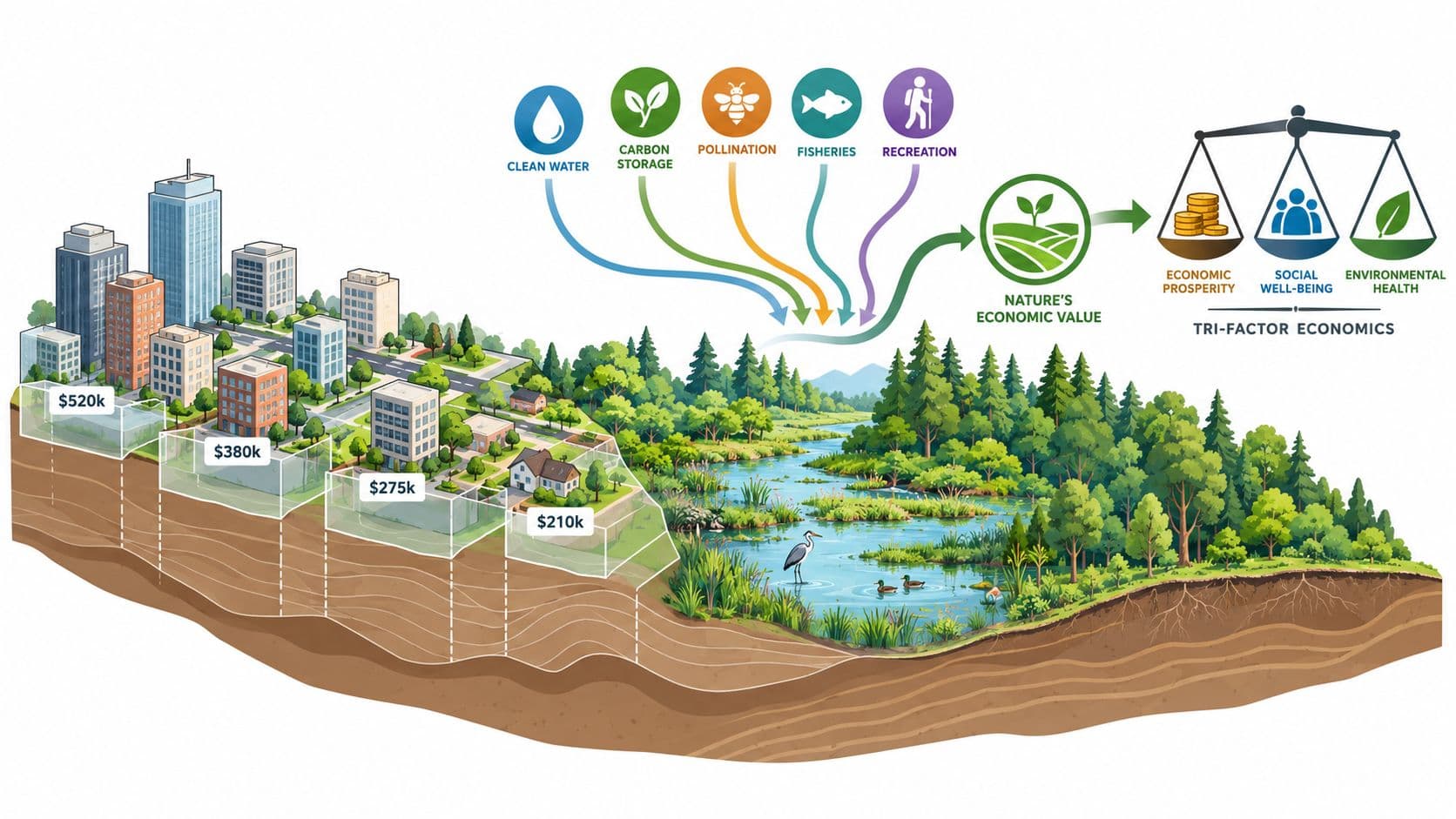
What valuation adds to resilience decisions
Land valuation helps answer three questions that hazard analysis alone won't resolve:
- Where is value at risk concentrated? High exposure in a low-value fringe area and moderate exposure in a critical urban service node don't create the same fiscal problem.
- Where does public action generate land uplift? Drainage upgrades, green corridors, transit protection, and flood defense can all change location value.
- Where is current land use undermining resilience? Idle serviced land, leapfrog development, and fragmented ownership often raise service costs and lock in avoidable exposure.
Nature valuation matters for the same reason. Wetlands, urban tree cover, floodplains, and coastal buffers aren't decorative extras. They provide protective functions that shape service continuity, health, and land performance. A solid ecosystem service valuation approach makes those functions visible in planning and budgeting.
Keep values current or the model goes stale
Static valuations are weak inputs for adaptation. If site values are frozen from old assessments, the public sector loses sight of where demand has shifted, where exposure is being capitalized into prices, and where resilience investment is creating new uplift.
In the Chinese land-rent literature, a recognized annual-repricing approach exists in which annual fees are updated as a fixed percentage of current market value, with updates occurring no more than once every three years, as noted in this policy guide on mass appraisal methods. The practical point is broader than one country. Resilience finance works better when land-related charges stay tied to current value rather than historical bargains.
Field lesson: If you want land policy to support adaptation, update the value base often enough that public charges and public risk stay connected.
Cadastre integration matters here. Ministries and cities need parcel identifiers, current use information, infrastructure overlays, and ecological layers that can be reconciled across departments. Without that, valuation remains an academic exercise. With it, valuation becomes a tool for targeting acquisitions, shaping zoning, estimating revenue, and identifying where nature protection is doing real economic work.
Choosing Land Value Capture Instruments Without Postponing Risk
Once land and ecological value are visible, the next question is how to capture part of that value for resilience funding. The right instrument depends on what you're trying to fund, how stable the revenue must be, and whether the mechanism reinforces or weakens good land use.
Three broad families usually matter. Site-value taxation can capture location value in a way that rewards construction and discourages speculative withholding. Resource dividends can return a share of nature-derived value to the public. Tenure-based instruments can also raise revenue, but their design determines whether they continuously price risk or defer it.
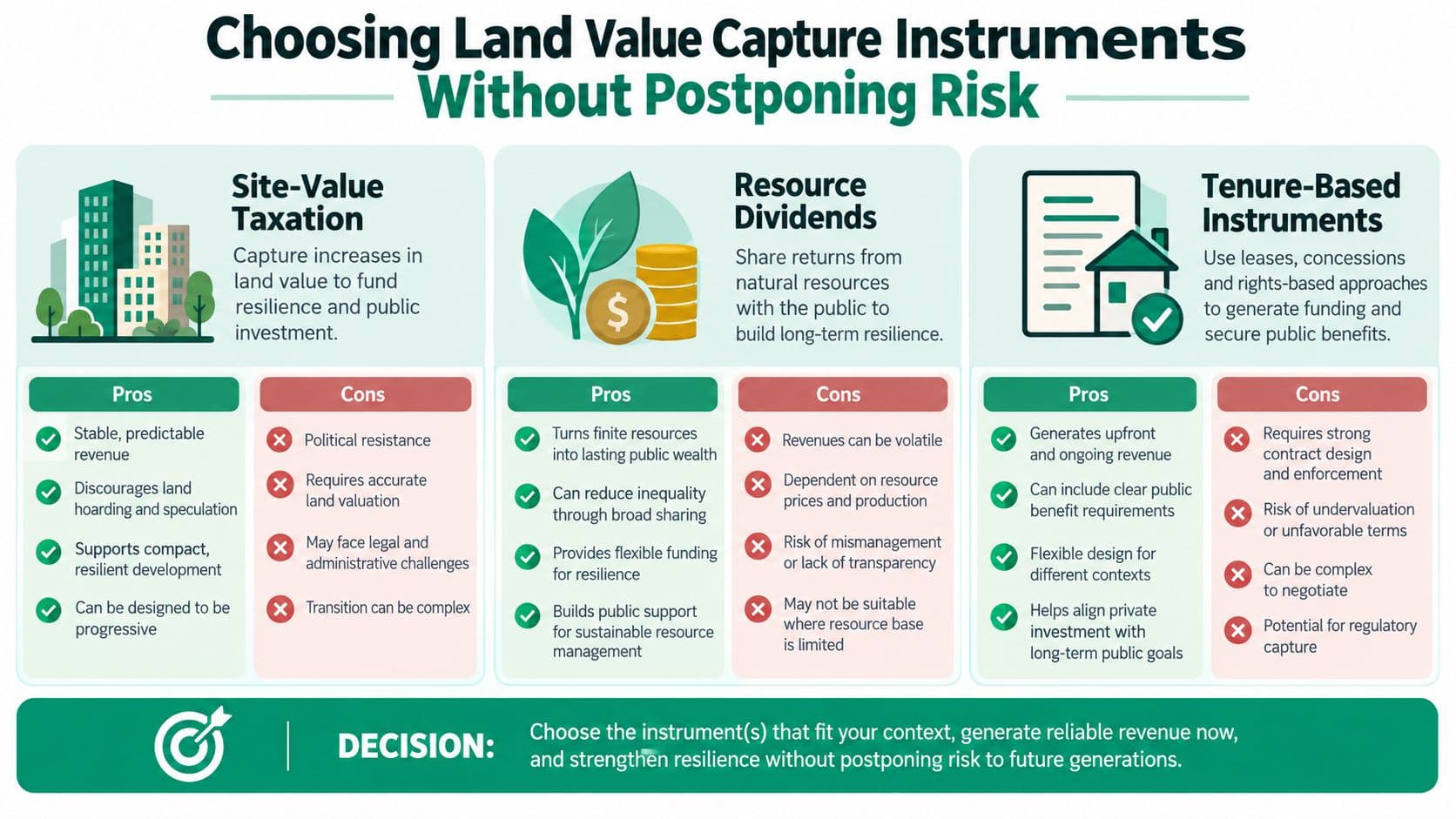
Compare instruments by behavior, not just yield
A finance ministry should ask more than “How much does it raise?” It should ask what behavior it rewards and how it handles changing risk.
- Site-value taxation: Best when government wants a broad, recurring revenue base linked to location value. It tends to support infill and efficient use because the charge falls on the site rather than the building.
- Resource dividends: Useful where natural assets or extraction rents are material and policymakers want a visible public return from nature-based value.
- Tenure-based instruments: These can work, but only if the tenure structure doesn't freeze prices for long periods and then force abrupt corrections later.
Don't confuse a lease with a genuine land-use right
This distinction matters more than most resilience plans acknowledge.
In a neutral comparison of land-tenure mechanics, a fixed-term land lease has a defined expiration date and a fixed price during the term, while a genuine land-use right is indefinite, requires no renewal, and is repriced each year, as set out in this comparison of leases and land-use rights. Sometimes fixed leases are mislabeled as land-use rights, but they aren't. If the arrangement expires, requires renewal, or doesn't reprice each year, it is still a fixed lease.
The financing consequences are substantial. Renewable fixed-term leases provide certainty only until renewal, when the gap between contract rent and market rent can be closed in a single repricing event. Non-renewable leases become progressively harder to refinance and sell as expiration approaches. In that sense, fixed-price leases don't correctly price risk. They postpone risk, as explained in this discussion of renewable and non-renewable lease risk.
China's land system is a useful reminder that long duration isn't the same as permanence. Residential land-use rights are typically granted for 70 years, commercial land for 40 years, and industrial land for 50 years, and those rights can be transferred, leased, and mortgaged for the remaining term, according to the World Bank's Urban China report section on land rights. Those are long-duration but still time-limited rights.
Land Lease vs Genuine Land Use Right for Resilience Finance
| Feature | Fixed Term Land Lease | Genuine Land Use Right |
|---|---|---|
| Duration | Defined term with expiration | Indefinite |
| Renewal | Required at term end if renewable | No renewal required |
| Pricing | Fixed during the term | Repriced each year |
| Market adjustment | Delayed, often abrupt at renewal | Continuous |
| Refinance and resale | Can weaken as expiry approaches, especially if non-renewable | Lower-friction transfer because the right doesn't run down |
| Risk treatment | Postpones risk | Prices risk continuously |
| Fit for resilience finance | Less stable and more distortionary over time | Better aligned with ongoing adaptation funding and changing land conditions |
For teams deciding among instruments, a grounded land value capture explained guide is useful because it forces the discussion back to mechanics rather than labels.
If public authorities want durable adaptation finance, they should favor instruments that reprice exposure and opportunity continuously instead of storing up political and fiscal shocks for later.
From Modeling to Delivery Through Fiscal Design Financing and Engagement
Good resilience programs don't jump from concept note to procurement. They move through a disciplined fiscal and administrative sequence. That sequence is where many reforms are lost, because the technical plan is stronger than the delivery machine behind it.
Model incidence before you legislate
Start with distributional and fiscal impact modeling. Decision-makers need to know who pays, who benefits, where revenues will land, and how quickly the transition can occur without destabilizing budgets or local markets.
A useful modeling package usually tests:
- Revenue stability: Whether the instrument can support recurrent maintenance as well as capital works.
- Spatial incidence: Which districts, parcels, or sectors carry the charge and which receive the first wave of protection.
- Transition pathways: Whether phasing, exemptions, credits, or offsetting tax changes are needed to keep the reform politically and economically workable.
- Administrative load: Whether the cadastre, billing systems, and appeals process can support the design.
When teams get serious about delivery, they often discover that financing and administration are inseparable. A dedicated funding source is weak if parcel records are incomplete. A sound legal framework is weak if agencies can't reconcile asset inventories with the tax base. That's why resilience finance belongs in the same room as cadastre modernization, billing reform, and capital planning. For practitioners working through that junction, infrastructure funding design is the right lens.
Build a financeable pipeline, not a wish list
Adaptation finance has grown, but it still doesn't remove the need for local fiscal discipline. The World Bank Group's 2021 to 2025 Climate Change Action Plan set a target to boost direct adaptation financing to US$50 billion over FY2021 to FY2025, or about US$10 billion per year, and in fiscal year 2021 it delivered about US$10.7 billion for adaptation. Yet global adaptation investment was still estimated at only about US$30 billion per year in 2017 to 2018, up from US$23 billion per year in 2015 to 2016, and still less than one-fifth of total climate finance, according to the World Bank adaptation action plan.
That funding environment favors prepared jurisdictions. The projects that move are the ones with screened risk, clear beneficiaries, workable land arrangements, and a funding source that survives after external finance closes.
Engagement has to be operational
Stakeholder engagement is often treated as a communications exercise. It isn't. It is part of implementation design.
Use different messages for different actors:
- Civil servants need process clarity: Who does the valuation, who approves rates, who maintains the asset register, who updates assumptions.
- Elected officials need trade-off clarity: Which taxes may fall, which charges may rise, where visible improvements will occur first.
- Communities need consequence clarity: What changes in service, cost, access, and protection they should expect, and on what timeline.
Short educational materials, public calculators, parcel-level examples, and agency training all matter more than abstract consultation language. If people can't trace how the instrument funds visible risk reduction, they'll assume it's just another revenue grab.
Keeping Resilience on Track With Monitoring Evaluation and Updates
A resilience plan starts to decay the day after adoption unless monitoring is built for operations, not optics. That's the lesson from Europe's adaptation experience. The European Environment Agency says planning and implementation are still disconnected, social vulnerability isn't systematically integrated, and adaptation progress is hard to verify because monitoring systems vary widely, in its assessment of Europe's uneven adaptation challenge. The common problem isn't only weak ambition. It's weak verification.
Track assets, owners, and maintenance obligations
Monitoring should answer practical questions first.
- Asset condition: Did the drain, cooling center, wetland buffer, or slope treatment stay functional through stress events?
- Risk ownership: Which agency was responsible before, during, and after the event?
- Maintenance performance: Was upkeep funded and completed on schedule?
- Distributional effect: Did vulnerable households receive better protection or service continuity?
S&P Global reports that since 2022 the number of companies disclosing broad adaptation plans has nearly tripled, but location- or asset-specific plans have grown only half as fast, according to its analysis of adaptation planning practice. Public systems have the same weakness. Broad commitments are easier than asset-specific management.
Monitoring test: If you can't tell which asset improved, who maintained it, and whether vulnerable groups benefited, you aren't measuring resilience yet.
Update the plan before reality outruns it
Update cycles should be scheduled, not improvised. Risks shift. Land values move. Asset conditions deteriorate. Political ownership changes. Financing assumptions weaken.
A durable update routine should include:
- Annual repricing or recalibration of land-related charges where the instrument depends on current value.
- Periodic review of asset-level assumptions for timing, maintenance needs, and service thresholds.
- Cross-agency review so health, planning, water, housing, and finance aren't each running separate resilience logics.
- Social vulnerability refresh to catch displacement, heat burden, and service inequality that physical infrastructure metrics often miss.
For teams tightening the evaluation side, a practical reference is this Grantlas guide to grant monitoring, especially for structuring evidence collection around funded programs rather than just approved plans.
A resilience system stays credible when it learns in public. It shows what changed, what failed, what cost more than expected, and what now needs to be repriced, redesigned, or retired.
Unitism® helps governments and cities connect land and nature valuation to practical fiscal reform, so resilience plans can move from broad intent to durable funding and implementation. If you're working on land-value capture, valuation frameworks, transition modeling, or the design of instruments that support adaptation without distorting productive investment, visit Unitism®.