Discover policy-oriented strategies for open space preservation. This guide covers planning, legal tools, and innovative financing like land-value capture.
July 5, 2026
Open Space Preservation: A Self-Funding City Guide
Discover policy-oriented strategies for open space preservation. This guide covers planning, legal tools, and innovative financing like land-value capture.
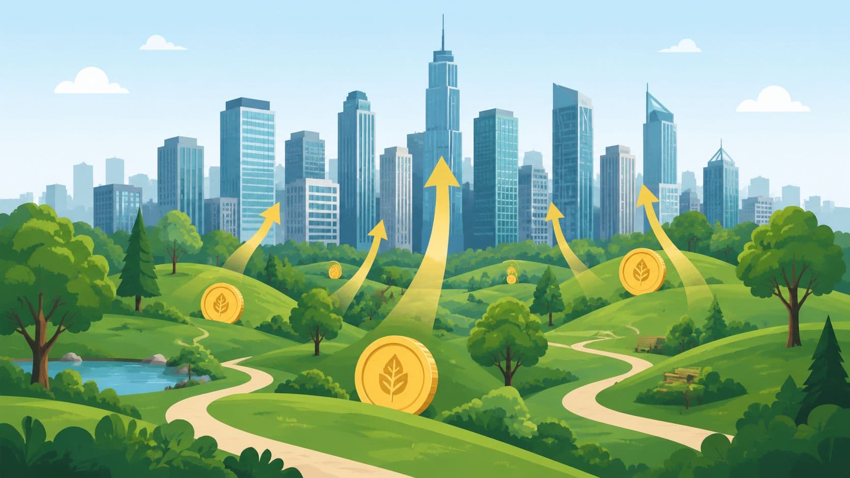
Most advice on open space preservation starts with sacrifice. Buy the land. Issue the bond. Raise the tax. Hope voters stay patient. That framing is politically familiar, but it's economically incomplete.
Communities aren't just preserving scenery when they protect floodplains, greenways, watersheds, farms, or urban parks. They're shaping land markets. They're changing where value concentrates, where risk falls, and which neighborhoods become more desirable. The overlooked question isn't whether preserved land has a cost. It does. The fundamental question is why cities so often ignore the value preservation creates around it, then call preservation unaffordable.
A more durable model starts from land economics, not charity. If protected open space increases nearby site values, lowers certain public risks, and improves the long-run functioning of a city, then the financing system should reflect that reality. Public value shouldn't depend entirely on taxing work, taxing buildings, or waiting for intermittent bond measures.
Table of Contents
- The Preservation Paradox
- Defining the Goals of Open Space Preservation
- The Preservationist's Policy Toolkit
- Funding Forever The Economics of Preservation
- A Municipal Roadmap to Preservation
- Global Inspiration Case Studies in Action
- The Path to a Thriving World
The Preservation Paradox
Every day, an estimated 6,000 acres of open space are converted to other uses, largely through expanding urban and suburban development, with losses to forests, grasslands, and habitat that also remove services like clean water filtration, natural flood control, and wildlife habitat, according to the U.S. Forest Service overview of open space loss.

That loss is usually described as an environmental problem. It is that. But for city leaders, it is also a fiscal design problem. When a municipality allows strategic open land to disappear, it often inherits the downstream costs of more runoff, more infrastructure extension, more exposure to flood damage, and fewer natural systems doing work that engineered systems then have to replace.
Why the usual fiscal story is too narrow
The common budget story says preserved land is “off the tax rolls” or “locked away from development.” That view counts the forgone transaction and the visible acquisition cost, but it often misses the way open space changes adjacent land values and neighborhood desirability.
That omission matters because land markets react quickly to public goods. People pay for access to parks, views, ecological quality, and reduced risk. In effect, communities create value with preservation, then frequently let that value be privately capitalized without building a public revenue mechanism around it.
Open space preservation isn't just about limiting damage. It's about recognizing where public action creates private locational advantage.
Preservation as productive infrastructure
A park system, conserved watershed, or floodplain corridor can function like infrastructure. Roads organize movement. Utilities organize service delivery. Open space organizes ecological resilience, neighborhood amenity, and urban form.
That's why the debate should move beyond sentiment. Preservation deserves the same seriousness as any long-lived public asset. The practical task is to identify what benefits the land provides, who gains from those benefits, and how part of that gain can support stewardship. For readers who want a deeper framework for pricing non-market benefits, ecosystem service valuation methods are a useful starting point.
The paradox is straightforward. Cities are losing open land fast, yet the land around what remains often becomes more valuable. If policymakers treat preservation only as a cost center, they'll underinvest in it. If they treat it as a value-creating public asset, they can design funding systems that last.
Defining the Goals of Open Space Preservation
Open space preservation isn't one thing. A river corridor that absorbs floodwater, an urban park used for recreation, a working agricultural area, and a habitat reserve can all fall under the same label while serving very different public purposes.
That distinction matters because cities make poor land decisions when they preserve land without defining the function they're paying for. A fiscal argument for a playground network won't look the same as a fiscal argument for wetland conservation or a regional greenbelt.
Not all open space produces the same kind of value
Researchers found that in 2016, 20.8% of land suitable for development within U.S. urban areas was preserved for open space, with an estimated annual opportunity cost of $172.6 billion, and preservation ranged from 3.0% to 72.1% across metropolitan areas. Yet the same research indicates that 97.39% of U.S. Metropolitan Statistical Areas likely have insufficient open space, meaning additional conservation would improve social welfare in most places, as detailed in this University of Chicago Press study on urban open space.
That finding should reset the debate. Preservation has an opportunity cost, but in most metropolitan areas the problem appears to be too little open space, not too much. The policy challenge isn't to deny tradeoffs. It's to identify which forms of open space generate the highest public return in each geography.
A working definition for policymakers
Cities should define open space by function, not by romance. In practice, that means at least four categories:
- Risk-reduction land like floodplains, wetlands, and watershed areas that reduce physical and fiscal exposure.
- Public-use land such as parks, trails, and greenways that support recreation and daily quality of life.
- Ecological land that protects habitat, biodiversity, and ecological connectivity.
- Working lands including farmland or managed open areas that preserve non-urban land functions while limiting sprawl.
The same study also notes that valuation differs by type. Greenbelts can increase nearby property values, while agricultural land converted to open space may have insignificant or even negative effects on home values. That's a reminder to stop talking about “open space” as if every acre performs the same economic role.
Policy test: If officials can't state the intended function of a preserved parcel, they probably can't justify the financing method either.
Open space as basic civic capacity
Municipal finance often treats roads, pipes, and public buildings as essentials, while treating green systems as optional amenities. That's a category error. A city without enough flood storage, enough neighborhood recreation space, or enough ecological buffering doesn't become efficient. It becomes brittle.
Housing advocates and conservation advocates often talk past each other. One side points to the cost of withholding developable land. The other points to environmental and community value. Both can be right in part. The useful move is to distinguish sites that should absorb growth from sites whose preservation raises overall welfare.
For communities sorting through land stewardship structures, what a land trust does and how it differs from other tools is worth understanding early. Governance matters as much as vision.
The Preservationist's Policy Toolkit
A municipality doesn't preserve land with slogans. It preserves land with instruments. The most reliable framework groups those instruments into planning, regulation, and acquisition. According to the Jordan River Commission summary of open space preservation tools, evidence shows that combining these approaches produces higher land retention rates than relying on a single method.
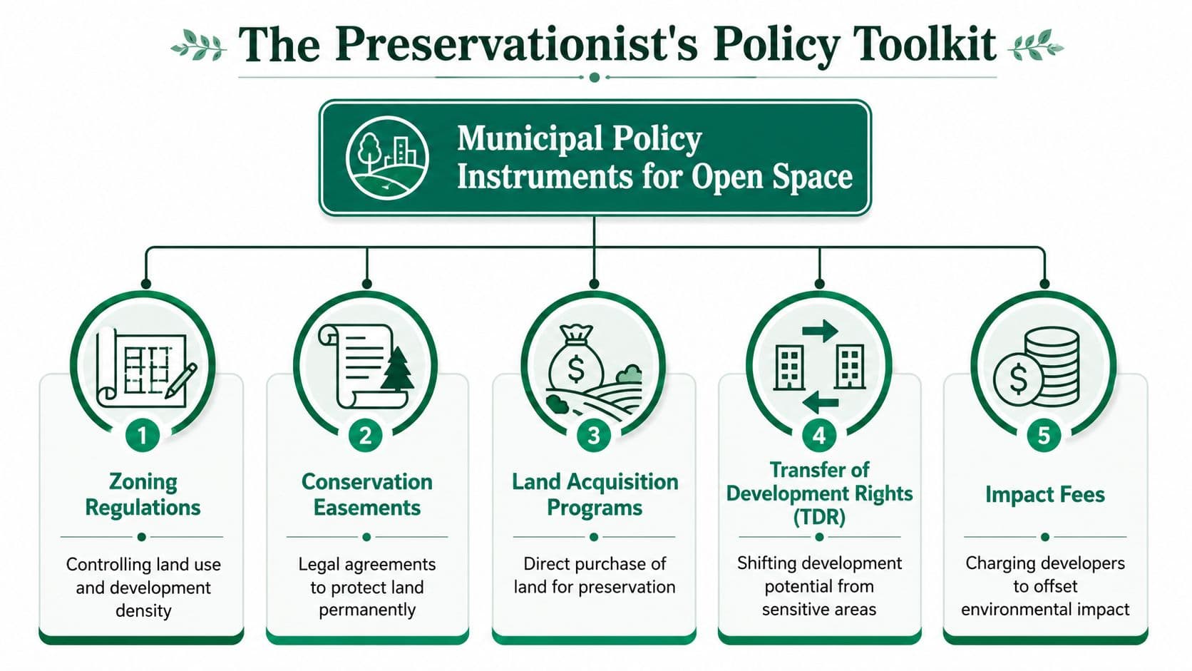
The categories sound administrative. They aren't. Each one answers a different question. Planning asks what should be protected. Regulation asks what rules will hold. Acquisition asks who controls the land interest and on what terms.
Planning decides where preservation matters most
Planning is the map before the law. Cities use GIS-based identification, land suitability analysis, hazard mapping, and growth scenarios to determine which parcels matter for habitat, access, flood management, recreation, or urban form.
Good planning doesn't freeze a city. It separates high-priority preservation land from high-priority growth land. That makes housing policy stronger, not weaker, because it reduces the temptation to fight every project on every site.
Examples include:
- Spatial targeting: Identify floodplains, stream corridors, steep slopes, habitat links, and underserved park areas before development pressure intensifies.
- Network logic: Preserve corridors and connected systems, not just isolated parcels that look attractive on a map.
- Growth alignment: Direct density toward serviced land while keeping high-function ecological land intact.
Regulation creates durability
Regulation translates a plan into enforceable expectations. Overlay ordinances, stream corridor protections, steep-slope rules, and conservation easements all belong here. Some are public-law tools. Others are long-term legal restrictions tied to the land.
The practical value of regulation is durability. A city can articulate a beautiful map and still lose the land if rules remain vague or politically reversible. Clear rules reduce discretion, and reduced discretion lowers both speculation and conflict.
One underappreciated example comes from floodplain management. Under the Community Rating System program, open space preservation requires land to be explicitly free from buildings, filling, paving, or other encroachment to flood flows, supported by a signed regulatory statement or owner declaration, as described by the Flood Science Center CRS profile. That technical clarity matters because it lets communities earn floodplain protection credits without requiring every preserved parcel to fit a simplistic undeveloped ideal.
The lesson is simple. Conservation policy works better when legal language is precise enough to administer.
Acquisition secures control where rules alone aren't enough
Certain open spaces are too valuable or too vulnerable to depend only on regulation. That's where acquisition enters. Municipalities and partner organizations can buy land outright, purchase development rights, or structure bargain sales.
Acquisition is expensive if used indiscriminately. It becomes strategic when reserved for parcels with outsized public function, legal complexity, or imminent development pressure. In practice, cities often need only partial interests, not full ownership.
A useful way to think about the acquisition menu:
| Tool | Best use | Main advantage | Main limit |
|---|---|---|---|
| Fee simple purchase | High-priority public access or habitat land | Full control | Highest upfront cost |
| Conservation easement | Long-term protection with continued private ownership | Durable and flexible | Requires monitoring |
| Purchase of development rights | Farmland or sensitive land under market pressure | Removes development option | Still needs funding |
| Bargain sale | Landowners willing to discount sale for public purpose | Can lower acquisition cost | Depends on willing sellers |
Municipalities that want to connect preservation tools to finance reform should also understand how land-value capture works in practice. Without a revenue model, even the best toolkit remains episodic.
Funding Forever The Economics of Preservation
The hardest question in open space preservation isn't ecological. It's financial durability. Cities can often fund acquisition once. They struggle to fund stewardship, expansion, and long-term maintenance without returning repeatedly to bonds, grants, or politically contested taxes.
The traditional model has a built-in weakness. It treats preservation as a budgetary burden while allowing surrounding landowners to keep much of the value preservation creates. That mismatch is why many preservation programs feel noble at launch and strained a few years later.
The missing revenue source is enhancement value
The core economic fact is plain. Protected watersheds and green spaces can dramatically raise nearby property values, yet many preservation plans don't capture that uplift to help pay for the public action that created it, as discussed in this Lincoln Institute paper on open space conservation finance.
That is the heart of the financing problem. A city preserves land. Adjacent sites become more desirable. Their owners receive a gain tied partly to public action and collective restraint. But the preservation budget remains dependent on separate revenue sources that may punish construction, labor, or transactions.
Why traditional funding keeps breaking down
Local governments usually reach for familiar tools because they're already in the toolbox.
| Mechanism | How It Works | Source of Funds | Economic Impact |
|---|---|---|---|
| General obligation bonds | Public borrowing for land purchase or capital programs | Broad tax base over time | Can secure land quickly, but creates repayment pressure and political cycles |
| Transaction taxes | Revenue from property transfers or related activity | Real estate market turnover | Volatile during market slowdowns and can discourage beneficial transactions |
| Grants and philanthropy | External funding for acquisition or restoration | Higher-level government or donors | Useful for catalytic projects, but not a stable base for perpetual stewardship |
| Land-value capture | Public revenue drawn from land value gains tied to location and public action | Site values and value uplift | Aligns funding with benefits created by preservation and urban amenity |
| Site-value taxation | Recurring tax focused more on land than improvements | Unimproved site value | Reduces penalties on building and can reward productive use of serviced land |
Bonds and grants aren't useless. They're often necessary. But they shouldn't be the entire model. A city that relies only on them is financing a long-lived asset with short-lived political attention.
The stronger model is to tax value where preservation creates it
A land-value capture approach starts with a simple premise. If public preservation increases the desirability of nearby land, then part of that increment should return to the public realm.
That can take several forms:
- Assessment districts near major green amenities where benefited land contributes to acquisition or maintenance.
- Site-value taxation that shifts the tax base toward land value and away from buildings, allowing cities to recover locational value without discouraging construction.
- Targeted value capture around restored corridors or waterfront parks where public investment clearly changes site desirability.
- Resource or ecological dividends in systems where shared natural value can be treated as a public revenue base rather than a private windfall.
Preservation policy becomes more than environmental management. It becomes public finance reform. The city no longer asks taxpayers to subsidize value creation that private landholders then capitalize for free. It asks land value, especially value enhanced by collective action, to help fund the system that produced it.
A preservation program becomes durable when revenue rises with the desirability of the places it protects.
That principle also broadens the coalition. Nonprofits and civic groups often still need mixed funding models in the early stages, and practical guides to strategies for mission-driven nonprofits can help organizations diversify while public finance catches up. But for municipalities, the long-run goal should be less dependence on episodic charity and more reliance on recurring land-based revenue.
Officials evaluating this shift need parcel-level modeling, not rhetoric. A serious starting point is learning how to calculate land value for policy design. If a city can identify where preservation creates locational gain, it can stop treating green space as a permanent fiscal orphan.
A Municipal Roadmap to Preservation
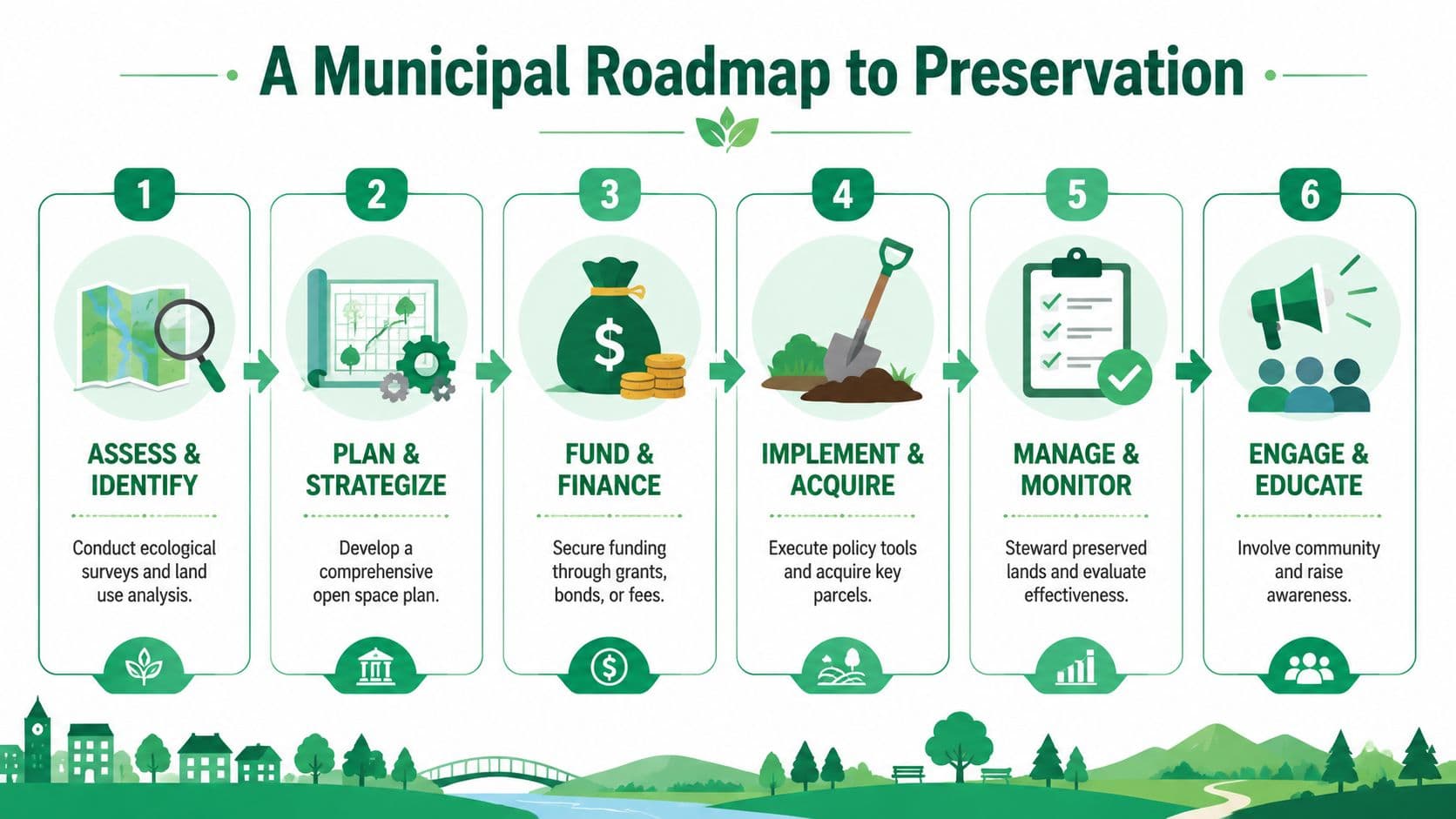
Policy succeeds when cities sequence it properly. Open space preservation fails less from bad intentions than from skipped steps. Officials acquire land before they map functions. They adopt rules before they build coalitions. They announce a funding source before they understand who benefits and who bears the cost.
A workable roadmap is disciplined. It joins land analysis, law, finance, and administration in one process.
Start with land function, not parcel sentiment
The first task is inventory. Map ecological corridors, flood-prone areas, underserved neighborhoods, existing park access, developable land, and likely growth pressure. The goal isn't to identify “nice” land. It's to identify land whose preservation solves a public problem.
At this stage, cities should classify parcels by role. Some sites need permanent protection. Others can support compact growth if regulations and infrastructure are aligned. That distinction prevents false choices between housing and conservation.
Build legitimacy before drafting instruments
Open space policy often becomes contentious when residents think preservation is a disguised anti-growth agenda or when landowners think the city is targeting them arbitrarily. Early engagement changes that dynamic.
Useful engagement asks concrete questions:
- Which lands reduce flood risk or water management costs?
- Which neighborhoods lack accessible public green space?
- Which privately held lands have strategic public value?
- Which growth areas can take more homes without pushing development into high-value natural land?
This is also where equity enters the process. If preservation only benefits already advantaged districts, public support will remain shallow.
Match tools to places
After the map and the coalition come the instruments. Cities should choose combinations, not favorites.
A typical municipal mix may include:
- Planning designations for corridor networks, watershed areas, and growth boundaries.
- Regulatory tools such as overlays, easements, or floodplain restrictions.
- Selective acquisition where ownership or development rights must be secured.
- Fiscal mechanisms that recover part of the land value created by the preserved system.
One practical administrative lesson comes from the CRS framework. Communities can earn floodplain protection credits when open space preservation includes a signed regulatory statement that prohibits encroachments to flood flows, which shows how implementation often turns on technical clarity rather than broad aspiration alone.
Implementation rule: The best policy instrument is the one your city can map, enforce, finance, and explain in plain language.
Design revenue before announcing scale
Many plans collapse because officials name acreage goals before naming a stable revenue source. The better order is reversed. Estimate likely enhancement zones, choose a value-capture method, phase it in, and align acquisition timing with expected revenue.
A sound financial design should answer four questions:
| Question | Why it matters |
|---|---|
| Which parcels gain value from the preserved asset? | Defines the benefit area |
| Is the value gain recurring or one-time? | Determines the right charge structure |
| Can the city reduce taxes on buildings or transactions as it captures more land value? | Improves political durability |
| Who administers valuation, billing, and compliance? | Converts theory into a functioning system |
Cities that need to test these shifts before adoption should run a fiscal impact analysis for land and tax reform options. The politics improve when officials can show not just what they want to preserve, but how the numbers and burdens will function.
Global Inspiration Case Studies in Action
The most useful examples of open space preservation rarely appear under a single tidy label. What one jurisdiction calls park finance, another treats as leasehold revenue, conservation acquisition, or public trust management. The lesson isn't to copy a legal form. It's to study how places connect land value, stewardship, and public benefit.
The places worth studying share one habit
They don't isolate preservation from the rest of the land system. They treat green assets as part of urban structure, fiscal structure, or long-term public wealth.
That's why practical comparative work often starts with institutions rather than slogans. A planning authority, a leasehold framework, a public land agency, or a conservation partnership can all serve the same underlying purpose if they retain some claim on value created by location and collective stewardship.
Useful patterns from the field
Some jurisdictions rely more heavily on public land control. Others preserve private ownership while restricting development through easements or purchased rights. Some use national park authorities or regional governance to hold the line where fragmented local politics might fail.
For readers looking at how land stewardship is communicated to market participants, Discover North York Moors buyer information offers a concrete example of how a place-based authority can present itself within a broader land and property ecosystem. The underlying point is modest but important. Preservation institutions work better when buyers, sellers, and communities understand the public role clearly.
The most convincing case study is often not a headline success. It's a place where the rules, funding logic, and land expectations fit together well enough to endure.
What policymakers should borrow, and what they shouldn't
Policymakers should borrow principles, not surface features.
They should borrow the idea that:
- preserved land needs a revenue logic, not just a moral logic
- governance matters as much as acquisition
- public gains shouldn't be financed entirely by taxing labor or construction
- long-run stewardship needs institutions that survive election cycles
They shouldn't assume that a celebrated park, greenbelt, or conservation district is self-sustaining because it is admired. Many admired systems still rely on unstable funding. A crucial test is whether the fiscal model captures enough of the land value and risk reduction that preservation creates.
That's the threshold for moving from scattered success to replicable policy.
The Path to a Thriving World
Open space preservation has been framed for too long as a budgetary concession. Preserve a little land if voters will bear the cost. Delay maintenance when money tightens. Hope philanthropy appears. That approach doesn't match how cities generate and distribute value.
Protected land does more than remain undeveloped. It shapes urban form, lowers certain risks, improves neighborhood quality, and changes what nearby locations are worth. Once that is understood, the policy implication follows. Preservation shouldn't be funded only by taxing effort and enterprise. It should be funded, at least in meaningful part, by the land value and shared natural value it helps create.
A better settlement between growth and conservation
Cities don't need to choose between housing, fiscal stability, and green space. They need to stop using blunt financing systems that pit those goals against each other. Growth belongs on the right land. Preservation belongs on the right land. Public finance should recognize both.
When governments capture a fair share of location value, they gain room to reduce taxes that suppress building, work, and productive investment. That changes the political character of preservation. It stops looking like a drag on development and starts looking like part of a healthier development model.
What durable leadership looks like
Leaders who get this right won't talk about open space as decorative. They'll treat it as civic capacity. They'll demand maps, legal clarity, valuation methods, and transparent revenue design. They'll insist that communities pay for public value in ways that reinforce, rather than undermine, long-run prosperity.
The old model asks residents to keep voting for sacrifice. The stronger model asks land economics to tell the truth. When public action creates private locational gain, part of that gain should return to the public.
That is how preservation becomes lasting. That is how a greener city also becomes a stronger one.
Unitism® helps governments, researchers, and civic leaders design land-based public finance that can support goals like open space preservation without leaning so heavily on taxes on work, building, and enterprise. If you're developing a reform agenda around land valuation, site-value taxation, or value capture, visit Unitism®.